
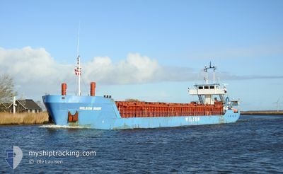
WILSON MAIN
General Cargo
Current Trip
| Time Travelled | 3 days |
|---|---|
| Remaining Time | --- |
| Distance Travelled | 645.28 nm |
| Remaining Distance | --- |
| AVG Speed | 7.6 Knop |
| MAX Speed | 12.5 Knop |
| AVG Wind | 13.4 knots |
| MAX Wind | 24.8 knots |
| MIN Temp | 2°C / 35.6°F |
| MAX Temp | 9.3°C / 48.74°F |
| Djupgående | 4.7 m |
| Position mottagen | 11 h, 6 m sen |
Current Position
| Longitud | --- |
|---|---|
| Latitude | --- |
| Status | Under way using engine |
| Fart | 7.1 Knop |
| Kurs | 50.7° |
| Område | Bristol Channel |
| Station | T-AIS |
| Position mottagen | 11 h, 6 m sen |
Info
Information
The current position of WILSON MAIN is in Bristol Channel with coordinates 51.14583° / -4.50153° as reported on 2025-02-17 12:51 by AIS to our vessel tracker app. The vessel's current speed is 7.1 Knop and is heading at the port of SHARPNESS. The estimated time of arrival as calculated by MyShipTracking vessel tracking app is 2025-02-17 21:00 LT
The vessel WILSON MAIN (IMO: 8913485, MMSI: 314182000) is a General Cargo that was built in 1990 ( 35 År gammal ). It's sailing under the flag of [BB] Barbados.
In this page you can find informations about the vessels current position, last detected port calls, and current voyage information. If the vessels is not in coverage by AIS you will find the latest position.
The current position of WILSON MAIN is detected by our AIS receivers and we are not responsible for the reliability of the data. The last position was recorded while the vessel was in Coverage by the Ais receivers of our vessel tracking app.
The current draught of WILSON MAIN as reported by AIS is 4.7 meters
Weather
| Temperature | 4.1°C / 39.38°F |
|---|---|
| Wind Speed | 15 knots |
| Direction | 110° ESE |
| Pressure | 1019.4 hPa |
| Humidity | 76.9 % |
| Cloud Coverage | 100 % |
Featured Company
Last Port Calls
| Port | Arrival | Departure | Time In Port |
|---|---|---|---|
| 2025-02-13 15:55 | 2025-02-14 14:47 | 22 h | |
| 2025-02-10 13:58 | 2025-02-11 23:44 | 1 d | |
| 2025-02-06 13:04 | 2025-02-07 16:17 | 1 d | |
| 2025-02-02 11:21 | 2025-02-04 16:41 | 2 d | |
| 2025-01-27 04:58 | 2025-01-28 00:12 | 19 h | |
| 2025-01-18 08:23 | 2025-01-20 02:35 | 1 d | |
| 2025-01-10 10:46 | 2025-01-11 15:01 | 1 d | |
| 2024-12-21 11:06 | 2024-12-23 09:44 | 1 d | |
| 2024-12-14 01:49 | 2024-12-17 14:05 | 3 d | |
| 2024-12-03 19:08 |
Last Trips
| Origin | Departure | Destination | Arrival | Distance | |
|---|---|---|---|---|---|
| 2025-02-12 00:44 | 2025-02-13 15:55 | 259.48 nm | |||
| 2025-02-07 17:17 | 2025-02-10 14:58 | 575.07 nm | |||
| 2025-02-04 17:41 | 2025-02-06 14:04 | 349.70 nm | |||
| 2025-01-28 01:12 | 2025-02-02 12:21 | 949.41 nm | |||
| 2025-01-20 03:35 | 2025-01-27 05:58 | 274.38 nm | |||
| 2025-01-11 16:01 | 2025-01-18 09:23 | 752.04 nm | |||
| 2024-12-23 10:44 | 2025-01-10 11:46 | 1474.63 nm | |||
| 2024-12-17 16:05 | 2024-12-21 12:06 | 726.43 nm | |||
| 2024-12-03 19:08 | 2024-12-14 03:49 | 1320.03 nm |
Events
| Tid | Event | Detaljer | Position / Dest | Information |
|---|---|---|---|---|
| 2025-02-17 18:16 | STOPPAR förflyttning | 2.77 nm, North West of WATCHET |
51.21381 / -3.38329
GBSSS
|
Fart: 0.2 kn Kurs: 300° |
| 2025-02-17 12:59 | Status ändrad | Default Under way using engine |
51.15670 / -4.47990
GBSSS
|
Fart: 7.1 kn Kurs: 50.7° |
| 2025-02-17 12:51 | UTANFÖR täckningsområde |
51.14583 / -4.50153
Bristol Channel
GBSSS
|
Fart: 7.1 kn Kurs: 50.7° |
|
| 2025-02-17 12:16 | Byter havsområde | United Kingdom part of the Bristol Channel United Kingdom part of the Celtic Sea |
51.10234 / -4.58106
Bristol Channel
GBSSS
|
Fart: 6.8 kn Kurs: 49.5° |
| 2025-02-17 07:57 | Status ändrad | Under way using engine Default |
50.70007 / -5.29610
GBSSS
|
Fart: 9.8 kn Kurs: 44° |
| 2025-02-17 07:43 | Status ändrad | Default Under way using engine |
50.67281 / -5.33760
GBSSS
|
Fart: 9.7 kn Kurs: 44° |
| 2025-02-17 06:25 | Status ändrad | Under way using engine Default |
50.51792 / -5.57240
GBSSS
|
Fart: 9.9 kn Kurs: 46° |
| 2025-02-17 06:23 | Status ändrad | Default Under way using engine |
50.51537 / -5.57657
GBSSS
|
Fart: 10 kn Kurs: 45.9° |
| 2025-02-17 06:13 | Status ändrad | Under way using engine Default |
50.49443 / -5.61074
GBSSS
|
Fart: 9.9 kn Kurs: 46° |
| 2025-02-17 06:11 | I täckningsområde |
50.49634 / -5.60763
Celtic Sea
GBSSS
|
Fart: 9.9 kn Kurs: 46.1° |