
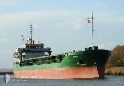
TUNA
General Cargo
Current Trip
SESTV
| Time Travelled | 1 day |
|---|---|
| Remaining Time | --- |
| Distance Travelled | 305.00 nm |
| Remaining Distance | --- |
| AVG Speed | 8.3 Knop |
| MAX Speed | 11.3 Knop |
| AVG Wind | 7.8 knots |
| MAX Wind | 18 knots |
| MIN Temp | 12°C / 53.6°F |
| MAX Temp | 17.7°C / 63.86°F |
| Djupgående | 5.4 m |
| Position mottagen | Nu |
Current Position
| Longitud | 14.16904° |
|---|---|
| Latitude | 55.17984° |
| Status | Under way using engine |
| Fart | 10.7 Knop |
| Kurs | 87° |
| Område | Baltic Sea |
| Station | T-AIS |
| Position mottagen | Nu |
Info
Information
The current position of TUNA is in Baltic Sea with coordinates 55.17984° / 14.16904° as reported on 2024-09-01 02:51 by AIS to our vessel tracker app. The vessel's current speed is 10.7 Knop
The vessel TUNA (IMO: 9306691, MMSI: 244321000) is a General Cargo that was built in 2004 ( 20 År gammal ). It's sailing under the flag of [NL] Netherlands.
In this page you can find informations about the vessels current position, last detected port calls, and current voyage information. If the vessels is not in coverage by AIS you will find the latest position.
The current position of TUNA is detected by our AIS receivers and we are not responsible for the reliability of the data. The last position was recorded while the vessel was in Coverage by the Ais receivers of our vessel tracking app.
The current draught of TUNA as reported by AIS is 5.4 meters
Weather
| Temperature | 17.9°C / 64.22°F |
|---|---|
| Wind Speed | 9 knots |
| Direction | 47° NE |
| Pressure | 1024.7 hPa |
| Humidity | 67.9 % |
| Cloud Coverage | 10 % |
Featured Company
Last Port Calls
| Port | Arrival | Departure | Time In Port |
|---|---|---|---|
| 2024-08-28 13:16 | 2024-08-30 05:48 | 1 d | |
| 2024-08-27 19:18 | 2024-08-27 20:23 | 1 h | |
| 2024-08-24 15:20 | 2024-08-25 07:13 | 15 h | |
| 2024-08-20 06:38 | 2024-08-20 19:53 | 13 h | |
| 2024-08-14 20:45 | 2024-08-15 15:21 | 18 h | |
| 2024-08-14 02:54 | 2024-08-14 04:04 | 1 h | |
| 2024-08-10 17:11 | 2024-08-11 23:45 | 1 d | |
| 2024-08-09 05:05 | |||
| 2024-08-05 07:13 | 2024-08-07 12:33 | 2 d | |
| 2024-08-03 08:04 | 2024-08-04 07:01 | 22 h |
Most Visited Ports (Last year)
| Port | Arrivals | |
|---|---|---|
| 8 | ||
| 6 | ||
| 5 | ||
| 5 | ||
| 5 | ||
| 5 |
Last Trips
| Origin | Departure | Destination | Arrival | Distance | |
|---|---|---|---|---|---|
| 2024-08-27 20:23 | 2024-08-28 13:16 | 118.95 nm | |||
| 2024-08-25 07:13 | 2024-08-27 19:18 | 591.26 nm | |||
| 2024-08-20 19:53 | 2024-08-24 15:20 | 628.98 nm | |||
| 2024-08-15 15:21 | 2024-08-20 06:38 | 766.01 nm | |||
| 2024-08-14 04:04 | 2024-08-14 20:45 | 118.34 nm | |||
| 2024-08-11 23:45 | 2024-08-14 02:54 | 448.90 nm | |||
| 2024-08-07 12:33 | 2024-08-09 05:05 | 385.37 nm | |||
| 2024-08-04 07:01 | 2024-08-05 07:13 | 211.28 nm | |||
| 2024-08-02 15:03 | 2024-08-03 08:04 | 118.53 nm | |||
| 2024-07-31 14:07 | 2024-08-02 14:45 | 505.40 nm |
Events
| Tid | Event | Detaljer | Position / Dest | Information |
|---|---|---|---|---|
| 2024-08-31 21:41 | Byter havsområde | Swedish part of the Baltic Sea Danish part of the Baltic Sea |
55.30047 / 12.64729
Baltic Sea
SESTV
|
Fart: 9.8 kn Kurs: 118° |
| 2024-08-31 21:32 | Upptäckt i hav | Danish part of the Baltic Sea |
55.32254 / 12.63955
Baltic Sea
SESTV
|
Fart: 10.1 kn Kurs: 189.3° |
| 2024-08-31 20:41 | Upptäckt i hav | Swedish part of the Kattegat |
55.46182 / 12.67871
Kattegat
SESTV
|
Fart: 9.8 kn Kurs: 189.1° |
| 2024-08-31 16:00 | Byter havsområde | Danish part of the Kattegat Swedish part of the Kattegat |
56.19431 / 12.39192
Kattegat
SESTV
|
Fart: 10.6 kn Kurs: 160.3° |
| 2024-08-31 06:59 | STARTAR förflyttning | 1.17 nm, North of ASPERO |
57.67005 / 11.79846
SESTV
|
Fart: 4.5 kn Kurs: 277° |
| 2024-08-31 06:59 | Status ändrad | Under way using engine At anchor |
57.66993 / 11.79925
SESTV
|
Fart: 3.2 kn Kurs: 282° |
| 2024-08-31 05:09 | Status ändrad | At anchor Under way using engine |
57.66946 / 11.80316
SESTV
|
Fart: Kurs: 281° |
| 2024-08-31 05:04 | STOPPAR förflyttning | 1.17 nm, North of ASPERO |
57.66965 / 11.80199
SESTV
|
Fart: 0.3 kn Kurs: 283° |
| 2024-08-31 01:09 | Status ändrad | Under way using engine Default |
58.04792 / 12.14696
SESTV
|
Fart: 10.1 kn Kurs: 169° |
| 2024-08-31 01:09 | I täckningsområde |
58.04473 / 12.14778
Kattegat
SESTV
|
Fart: 9.8 kn Kurs: 174.3° |