
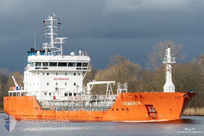
TRAVIATA
Tanker
Current Trip
| Time Travelled | 2 days |
|---|---|
| Remaining Time | 1 day |
| Distance Travelled | 256.69 nm |
| Remaining Distance | 448.13 nm |
| AVG Speed | 8.8 Knop |
| MAX Speed | 11.4 Knop |
| AVG Wind | 23.9 knots |
| MAX Wind | 29.2 knots |
| MIN Temp | -0.4°C / 31.28°F |
| MAX Temp | 4.6°C / 40.28°F |
| Djupgående | 6.9 m |
| Position mottagen | 14 h, 19 m sen |
Current Position
| Longitud | --- |
|---|---|
| Latitude | --- |
| Status | Under way using engine |
| Fart | 10.3 Knop |
| Kurs | 241.6° |
| Område | Baltic Sea |
| Station | T-AIS |
| Position mottagen | 14 h, 19 m sen |
Info
Information
The current position of TRAVIATA is in Baltic Sea with coordinates 59.50232° / 22.55978° as reported on 2024-11-22 08:50 by AIS to our vessel tracker app. The vessel's current speed is 10.3 Knop and is heading at the port of GOTEBORG. The estimated time of arrival as calculated by MyShipTracking vessel tracking app is 2024-11-24 18:03 LT
The vessel TRAVIATA (IMO: 9684122, MMSI: 209221000) is a Tanker It's sailing under the flag of [CY] Cyprus.
In this page you can find informations about the vessels current position, last detected port calls, and current voyage information. If the vessels is not in coverage by AIS you will find the latest position.
The current position of TRAVIATA is detected by our AIS receivers and we are not responsible for the reliability of the data. The last position was recorded while the vessel was in Coverage by the Ais receivers of our vessel tracking app.
The current draught of TRAVIATA as reported by AIS is 6.9 meters
Weather
| Temperature | 0.7°C / 33.26°F |
|---|---|
| Wind Speed | 15 knots |
| Direction | 273° W |
| Pressure | 996.6 hPa |
| Humidity | 56.1 % |
| Cloud Coverage | 99 % |
Featured Company
Last Port Calls
| Port | Arrival | Departure | Time In Port |
|---|---|---|---|
| 2024-11-19 05:44 | 2024-11-20 22:43 | 1 d | |
| 2024-11-16 20:19 | 2024-11-17 17:27 | 21 h | |
| 2024-11-12 20:44 | 2024-11-13 07:47 | 11 h | |
| 2024-11-08 20:52 | 2024-11-10 07:23 | 1 d | |
| 2024-11-03 14:44 | 2024-11-05 03:09 | 1 d | |
| 2024-10-28 16:01 | 2024-10-29 12:57 | 20 h | |
| 2024-10-24 00:09 | 2024-10-25 07:27 | 1 d | |
| 2024-10-18 07:01 | 2024-10-20 17:08 | 2 d | |
| 2024-10-15 22:38 | 2024-10-17 05:01 | 1 d | |
| 2024-10-13 17:18 | 2024-10-15 09:37 | 1 d |
Most Visited Ports (Last year)
| Port | Arrivals | |
|---|---|---|
| 14 | ||
| 9 | ||
| 8 | ||
| 7 | ||
| 7 | ||
| 6 |
Last Trips
| Origin | Departure | Destination | Arrival | Distance | |
|---|---|---|---|---|---|
| 2024-11-17 19:27 | 2024-11-19 07:44 | 5.91 nm | |||
| 2024-11-13 08:47 | 2024-11-16 22:19 | 635.71 nm | |||
| 2024-11-10 08:23 | 2024-11-12 21:44 | 620.52 nm | |||
| 2024-11-05 04:09 | 2024-11-08 21:52 | 305.48 nm | |||
| 2024-10-29 13:57 | 2024-11-03 15:44 | 482.17 nm | |||
| 2024-10-25 09:27 | 2024-10-28 17:01 | 482.79 nm | |||
| 2024-10-20 19:08 | 2024-10-24 02:09 | 448.31 nm | |||
| 2024-10-17 07:01 | 2024-10-18 09:01 | 313.31 nm | |||
| 2024-10-15 11:37 | 2024-10-16 00:38 | 120.32 nm | |||
| 2024-10-13 11:50 | 2024-10-13 19:18 | 59.35 nm |
Events
| Tid | Event | Detaljer | Position / Dest | Information |
|---|---|---|---|---|
| 2024-11-22 23:10 | Status ändrad | Under way using engine Default |
57.73531 / 19.63910
SEGOT
|
Fart: 11.4 kn Kurs: 218° |
| 2024-11-22 09:02 | Status ändrad | Default Under way using engine |
59.48677 / 22.50119
SEGOT
|
Fart: 10.3 kn Kurs: 241.6° |
| 2024-11-22 08:50 | UTANFÖR täckningsområde |
59.50232 / 22.55978
Baltic Sea
SEGOT
|
Fart: 10.3 kn Kurs: 241.6° |
|
| 2024-11-22 07:08 | Byter havsområde | Finnish part of the Baltic Sea Finnish part of the Gulf of Finland |
59.59110 / 23.09938
Baltic Sea
SEGOT
|
Fart: 10.4 kn Kurs: 253.4° |
| 2024-11-22 04:50 | Status ändrad | Under way using engine Default |
59.69947 / 23.78130
SEGOT
|
Fart: 9 kn Kurs: 256° |
| 2024-11-22 04:48 | Status ändrad | Default Under way using engine |
59.70037 / 23.78843
SEGOT
|
Fart: 8.6 kn Kurs: 256.5° |
| 2024-11-22 04:43 | Status ändrad | Under way using engine Default |
59.70343 / 23.81342
SEGOT
|
Fart: 8.6 kn Kurs: 256° |
| 2024-11-22 04:37 | Status ändrad | Default Under way using engine |
59.70658 / 23.83938
SEGOT
|
Fart: 8.7 kn Kurs: 254.5° |
| 2024-11-22 04:33 | Status ändrad | Under way using engine Default |
59.70873 / 23.85632
SEGOT
|
Fart: 8.2 kn Kurs: 253° |
| 2024-11-22 03:28 | UTANFÖR täckningsområde |
59.74709 / 24.14301
Gulf of Finland
SEGOT
|
Fart: 8.5 kn Kurs: 256.5° |