
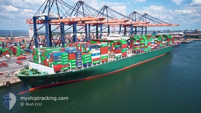
THALASSA MANA
Container Ship
Current Trip
| Trip Time | 20 days |
|---|---|
| Trip Distance | 8807.49 nm |
| AVG Speed | 18.6 Knop |
| MAX Speed | 23.5 Knop |
| Djupgående | 11.4 m |
| AVG Wind | 12.7 knots |
| MAX Wind | 39 knots |
| MIN Temp | 2°C / 35.6°F |
| MAX Temp | 31.9°C / 89.42°F |
| Position mottagen | 11 h, 1 m sen |
Current Position
| Longitud | 121.36858° |
|---|---|
| Latitude | 35.89001° |
| Status | Under way using engine |
| Fart | 14.9 Knop |
| Kurs | 300.4° |
| Område | Yellow Sea |
| Station | T-AIS |
| Position mottagen | 11 h, 1 m sen |
Info
Information
The current position of THALASSA MANA is in Yellow Sea with coordinates 35.89001° / 121.36858° as reported on 2024-05-13 20:42 by AIS to our vessel tracker app. The vessel's current speed is 14.9 Knop and is currently inside the port of QINGDAO.
The vessel THALASSA MANA (IMO: 9667150, MMSI: 636018700) is a Container Ship that was built in 2014 ( 10 År gammal ). It's sailing under the flag of [LR] Liberia.
In this page you can find informations about the vessels current position, last detected port calls, and current voyage information. If the vessels is not in coverage by AIS you will find the latest position.
The current position of THALASSA MANA is detected by our AIS receivers and we are not responsible for the reliability of the data. The last position was recorded while the vessel was in Coverage by the Ais receivers of our vessel tracking app.
The current draught of THALASSA MANA as reported by AIS is 11.4 meters
Weather
| Temperature | 17.9°C / 64.22°F |
|---|---|
| Wind Speed | 13 knots |
| Direction | 180° S |
| Pressure | 1011.8 hPa |
| Humidity | 69.5 % |
| Cloud Coverage | --- |
Featured Company
Last Port Calls
| Port | Arrival | Departure | Time In Port |
|---|---|---|---|
| 2024-05-14 00:24 | |||
| 2024-04-20 13:42 | 2024-04-23 00:44 | 2 d | |
| 2024-04-14 09:45 | 2024-04-16 01:14 | 1 d | |
| 2024-04-11 07:07 | 2024-04-12 06:53 | 23 h | |
| 2024-04-07 13:53 | 2024-04-08 08:56 | 19 h | |
| 2024-04-04 18:41 | 2024-04-06 20:49 | 2 d | |
| 2024-03-29 02:41 | 2024-03-30 12:05 | 1 d | |
| 2024-03-25 21:06 | 2024-03-26 14:43 | 17 h | |
| 2024-03-18 17:57 | 2024-03-19 14:45 | 20 h |
Last Trips
| Origin | Departure | Destination | Arrival | Distance | |
|---|---|---|---|---|---|
| 2024-04-22 19:44 | 2024-05-14 08:24 | 8807.49 nm | |||
| 2024-04-15 21:14 | 2024-04-20 08:42 | 2048.90 nm | |||
| 2024-04-12 02:53 | 2024-04-14 05:45 | 447.55 nm | |||
| 2024-04-08 04:56 | 2024-04-11 03:07 | 902.03 nm | |||
| 2024-04-06 16:49 | 2024-04-07 09:53 | 129.53 nm | |||
| 2024-03-30 07:05 | 2024-04-04 14:41 | 1600.54 nm | |||
| 2024-03-26 09:43 | 2024-03-28 21:41 | 86.54 nm | |||
| 2024-03-19 09:45 | 2024-03-25 16:06 | 19.60 nm | |||
| 2024-02-19 13:42 | 2024-03-18 12:57 | 8256.29 nm |
Events
| Tid | Event | Detaljer | Position / Dest | Information |
|---|---|---|---|---|
| 2024-05-14 01:49 | STOPPAR förflyttning |
36.00063 / 120.19801
[CN] QINGDAO
|
Fart: 0.1 kn Kurs: 222° |
|
| 2024-05-14 00:24 | ANLÄNDER HAMN |
|
36.02159 / 120.35552
[CN] QINGDAO
|
Fart: 15.6 kn Kurs: 281° |
| 2024-05-13 20:49 | Status ändrad | Default Under way using engine |
35.90391 / 121.33908
PAPAN>CNTAO
|
Fart: 14.9 kn Kurs: 300.4° |
| 2024-05-13 20:42 | UTANFÖR täckningsområde |
35.89001 / 121.36858
Yellow Sea
PAPAN>CNTAO
|
Fart: 14.9 kn Kurs: 300.4° |
|
| 2024-05-13 20:40 | Status ändrad | Under way using engine Default |
35.88651 / 121.37594
PAPAN>CNTAO
|
Fart: 14.9 kn Kurs: 300° |
| 2024-05-13 20:37 | Status ändrad | Default Under way using engine |
35.87896 / 121.39167
PAPAN>CNTAO
|
Fart: 14.7 kn Kurs: 301° |
| 2024-05-13 20:29 | Status ändrad | Under way using engine Default |
35.86300 / 121.42461
PAPAN>CNTAO
|
Fart: 14.8 kn Kurs: 303° |
| 2024-05-13 20:20 | Status ändrad | Default Under way using engine |
35.84454 / 121.46080
PAPAN>CNTAO
|
Fart: 14.7 kn Kurs: 302.2° |
| 2024-05-13 20:16 | Byter havsområde | Chinese part of the Yellow Sea Japanese part of the Japan Sea |
35.83413 / 121.48090
Yellow Sea
PAPAN>CNTAO
|
Fart: 14.7 kn Kurs: 302.2° |
| 2024-05-13 20:16 | Status ändrad | Under way using engine Default |
35.83413 / 121.48090
PAPAN>CNTAO
|
Fart: 14.8 kn Kurs: 302° |