
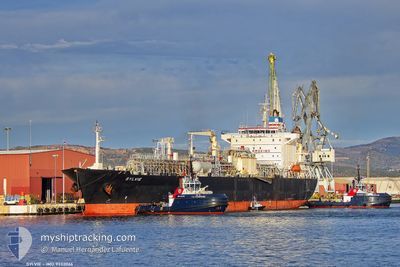
SYLVIE
Lpg Tanker
Current Trip
| Time Travelled | 11 days |
|---|---|
| Remaining Time | 20 h, 58 mins |
| Distance Travelled | 3418.37 nm |
| Remaining Distance | 248.68 nm |
| AVG Speed | 12.2 Knop |
| MAX Speed | 15.6 Knop |
| AVG Wind | 9.9 knots |
| MAX Wind | 22 knots |
| MIN Temp | 8.5°C / 47.3°F |
| MAX Temp | 17.2°C / 62.96°F |
| Djupgående | 7 m |
| Position mottagen | 23 m sen |
Current Position
| Longitud | --- |
|---|---|
| Latitude | --- |
| Status | Under way using engine |
| Fart | 11 Knop |
| Kurs | 32° |
| Område | Aegean Sea |
| Station | T-AIS |
| Position mottagen | 23 m sen |
Info
Information
The current position of SYLVIE is in Aegean Sea with coordinates 38.84142° / 25.18553° as reported on 2025-01-05 06:03 by AIS to our vessel tracker app. The vessel's current speed is 11 Knop and is heading at the port of TUZLA. The estimated time of arrival as calculated by MyShipTracking vessel tracking app is 2025-01-06 03:24 LT
The vessel SYLVIE (IMO: 9332066, MMSI: 477690200) is a Lpg Tanker that was built in 2007 ( 18 År gammal ). It's sailing under the flag of [HK] Hong Kong.
In this page you can find informations about the vessels current position, last detected port calls, and current voyage information. If the vessels is not in coverage by AIS you will find the latest position.
The current position of SYLVIE is detected by our AIS receivers and we are not responsible for the reliability of the data. The last position was recorded while the vessel was in Coverage by the Ais receivers of our vessel tracking app.
The current draught of SYLVIE as reported by AIS is 7 meters
Weather
| Temperature | 13.2°C / 55.76°F |
|---|---|
| Wind Speed | 10 knots |
| Direction | 18° NNE |
| Pressure | 1019 hPa |
| Humidity | 77.9 % |
| Cloud Coverage | 65 % |
Featured Company
Last Port Calls
| Port | Arrival | Departure | Time In Port |
|---|---|---|---|
| 2024-12-23 18:58 | 2024-12-24 18:03 | 23 h | |
| 2024-12-18 14:19 | 2024-12-19 19:11 | 1 d | |
| 2024-12-12 18:49 | 2024-12-14 03:39 | 1 d | |
| 2024-12-04 19:43 | 2024-12-06 18:29 | 1 d | |
| 2024-11-10 08:45 | 2024-11-11 15:54 | 1 d | |
| 2024-11-07 00:03 | 2024-11-08 22:57 | 1 d |
Last Trips
| Origin | Departure | Destination | Arrival | Distance | |
|---|---|---|---|---|---|
| 2024-12-19 20:11 | 2024-12-23 18:58 | 1075.91 nm | |||
| 2024-12-14 04:39 | 2024-12-18 15:19 | 1207.03 nm | |||
| 2024-12-06 21:29 | 2024-12-12 19:49 | 1626.98 nm | |||
| 2024-11-11 16:54 | 2024-12-04 22:43 | 3472.34 nm | |||
| 2024-11-08 22:57 | 2024-11-10 09:45 | 440.28 nm | |||
| 2024-10-26 15:08 | 2024-11-07 00:03 | 3626.13 nm |
Events
| Tid | Event | Detaljer | Position / Dest | Information |
|---|---|---|---|---|
| 2025-01-05 06:07 | Status ändrad | Default Under way using engine |
38.85337 / 25.19390
TRTUZ
|
Fart: 11 kn Kurs: 32° |
| 2025-01-05 05:42 | Status ändrad | Under way using engine Default |
38.78382 / 25.14397
TRTUZ
|
Fart: 12.2 kn Kurs: 25° |
| 2025-01-05 04:59 | Status ändrad | Default Under way using engine |
38.65428 / 25.06553
TRTUZ
|
Fart: 12 kn Kurs: 26° |
| 2025-01-04 18:13 | Byter havsområde | Greek part of the Aegean Sea Maltese part of the Mediterranean Sea - Eastern Basin |
36.86088 / 23.72650
Aegean Sea
TRTUZ
|
Fart: 12.6 kn Kurs: 23° |
| 2025-01-04 18:11 | Status ändrad | Under way using engine Default |
36.85327 / 23.72230
TRTUZ
|
Fart: 12.6 kn Kurs: 24° |
| 2025-01-04 18:11 | I täckningsområde |
36.86088 / 23.72650
Aegean Sea
TRTUZ
|
Fart: 12.6 kn Kurs: 23° |
|
| 2025-01-03 03:05 | Status ändrad | Default Under way using engine |
36.22913 / 14.67343
TRTUZ
|
Fart: 12.5 kn Kurs: 96° |
| 2025-01-03 02:59 | UTANFÖR täckningsområde |
36.23152 / 14.64905
Mediterranean Sea - Eastern Basin
TRTUZ
|
Fart: 12.5 kn Kurs: 96° |
|
| 2025-01-03 02:54 | Status ändrad | Under way using engine Default |
36.23365 / 14.62640
TRTUZ
|
Fart: 12.2 kn Kurs: 97° |
| 2025-01-03 02:49 | Status ändrad | Default Under way using engine |
36.23595 / 14.60553
TRTUZ
|
Fart: 12.1 kn Kurs: 98° |