
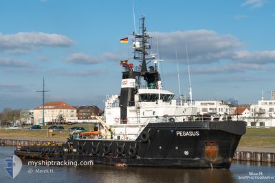
PEGASUS
Tug
Current Trip
| Time Travelled | 9 days |
|---|---|
| Remaining Time | 4 h, 13 mins |
| Distance Travelled | 212.30 nm |
| Remaining Distance | 21.37 nm |
| AVG Speed | 4.9 Knop |
| MAX Speed | 10.7 Knop |
| AVG Wind | 15.9 knots |
| MAX Wind | 25 knots |
| MIN Temp | 16°C / 60.8°F |
| MAX Temp | 20.8°C / 69.44°F |
| Djupgående | 5.4 m |
| Position mottagen | 1 m sen |
Current Position
| Longitud | 4.46497° |
|---|---|
| Latitude | 53.01783° |
| Status | Restricted manoeuverability |
| Fart | 4.4 Knop |
| Kurs | 153° |
| Område | North Sea |
| Station | T-AIS |
| Position mottagen | 1 m sen |
Info
Information
The current position of PEGASUS is in North Sea with coordinates 53.01783° / 4.46497° as reported on 2024-09-08 04:37 by AIS to our vessel tracker app. The vessel's current speed is 4.4 Knop and is heading at the port of DEN HELDER. The estimated time of arrival as calculated by MyShipTracking vessel tracking app is 2024-09-08 10:51 LT
The vessel PEGASUS (IMO: 9433743, MMSI: 305389000) is a Tug that was built in 2009 ( 15 År gammal ). It's sailing under the flag of [AG] Antigua Barbuda.
In this page you can find informations about the vessels current position, last detected port calls, and current voyage information. If the vessels is not in coverage by AIS you will find the latest position.
The current position of PEGASUS is detected by our AIS receivers and we are not responsible for the reliability of the data. The last position was recorded while the vessel was in Coverage by the Ais receivers of our vessel tracking app.
The current draught of PEGASUS as reported by AIS is 5.4 meters
Weather
| Temperature | 19.5°C / 67.1°F |
|---|---|
| Wind Speed | 12 knots |
| Direction | 205° SSW |
| Pressure | 1007.3 hPa |
| Humidity | 91.6 % |
| Cloud Coverage | 100 % |
Featured Company
Last Port Calls
| Port | Arrival | Departure | Time In Port |
|---|---|---|---|
| 2024-08-27 14:46 | 2024-08-29 18:07 | 2 d | |
| 2024-08-20 12:16 | 2024-08-26 12:13 | 5 d | |
| 2024-08-14 07:19 | 2024-08-14 20:40 | 13 h | |
| 2024-07-28 12:02 | 2024-08-12 21:13 | 15 d | |
| 2024-07-23 12:12 | 2024-07-27 15:06 | 4 d | |
| 2024-07-13 13:03 | 2024-07-13 21:16 | 8 h | |
| 2024-07-03 06:38 | 2024-07-07 08:13 | 4 d |
Most Visited Ports (Last year)
| Port | Arrivals | |
|---|---|---|
| 23 | ||
| 5 | ||
| 3 | ||
| 2 | ||
| 2 | ||
| 2 |
Last Trips
| Origin | Departure | Destination | Arrival | Distance | |
|---|---|---|---|---|---|
| 2024-08-26 12:13 | 2024-08-27 14:46 | 145.22 nm | |||
| 2024-08-14 20:40 | 2024-08-20 12:16 | 160.94 nm | |||
| 2024-08-12 21:13 | 2024-08-14 07:19 | 222.67 nm | |||
| 2024-07-27 15:06 | 2024-07-28 12:02 | 241.60 nm | |||
| 2024-07-13 21:16 | 2024-07-23 12:12 | 248.33 nm | |||
| 2024-07-07 08:13 | 2024-07-13 13:03 | 147.02 nm | |||
| 2024-06-23 11:27 | 2024-07-03 06:38 | 151.49 nm |
Events
| Tid | Event | Detaljer | Position / Dest | Information |
|---|---|---|---|---|
| 2024-09-08 02:52 | Djupgående ändrat | 5.4 5.6 |
53.11640 / 4.30035
NLDHR
|
Fart: 5.1 kn Kurs: 130.2° |
| 2024-09-08 02:52 | ETA ändrat | 2024/09/08 08:00 2024/09/08 09:00 |
53.11640 / 4.30035
NLDHR
|
Fart: 5.1 kn Kurs: 130.2° |
| 2024-09-08 02:05 | Status ändrad | Restricted manoeuverability Default |
53.17471 / 4.23690
NLDHR
|
Fart: 5.4 kn Kurs: 157° |
| 2024-09-08 01:49 | Status ändrad | Default Restricted manoeuverability |
53.19623 / 4.22100
NLDHR
|
Fart: 5.3 kn Kurs: 155.9° |
| 2024-09-08 01:04 | Status ändrad | Restricted manoeuverability Default |
53.25706 / 4.17426
NLDHR
|
Fart: 5.5 kn Kurs: 156° |
| 2024-09-08 00:59 | I täckningsområde |
53.25635 / 4.17480
North Sea
NLDHR
|
Fart: 5.4 kn Kurs: 155.7° |
|
| 2024-09-07 23:04 | Status ändrad | Default Restricted manoeuverability |
53.44544 / 4.11008
NLDHR
|
Fart: 5.8 kn Kurs: 174° |
| 2024-09-07 22:56 | Status ändrad | Restricted manoeuverability Default |
53.45833 / 4.10787
NLDHR
|
Fart: 5.8 kn Kurs: 174° |
| 2024-09-07 22:56 | UTANFÖR täckningsområde |
53.45833 / 4.10787
North Sea
NLDHR
|
Fart: 5.8 kn Kurs: 174° |
|
| 2024-09-07 22:38 | I täckningsområde |
53.45833 / 4.10787
North Sea
NLDHR
|
Fart: 5.8 kn Kurs: 174° |