
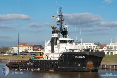
PEGASUS
Tug
Current Trip
PLATFORM L7H
| Time Travelled | 2 days |
|---|---|
| Remaining Time | --- |
| Distance Travelled | 20.05 nm |
| Remaining Distance | --- |
| AVG Speed | 6.1 Knots |
| MAX Speed | 7.3 Knots |
| AVG Wind | 8.7 knots |
| MAX Wind | 10 knots |
| MIN Temp | 15.6°C / 60.08°F |
| MAX Temp | 16.2°C / 61.16°F |
| Dybgang | 5.4 m |
| Position Modtaget | 1 d siden |
Current Position
| Longitude | 4.44633° |
|---|---|
| Latitude | 53.03939° |
| Status | Restricted manoeuverability |
| Fart | 5.6 Knots |
| Kurs | 331.9° |
| Område | North Sea |
| Station | T-AIS |
| Position Modtaget | 1 d siden |
Info
Information
The current position of PEGASUS is in North Sea with coordinates 53.03939° / 4.44633° as reported on 2024-09-14 21:13 by AIS to our vessel tracker app. The vessel's current speed is 5.6 Knots
The vessel PEGASUS (IMO: 9433743, MMSI: 305389000) is a Tug that was built in 2009 ( 15 år gamle ). It's sailing under the flag of [AG] Antigua Barbuda.
In this page you can find informations about the vessels current position, last detected port calls, and current voyage information. If the vessels is not in coverage by AIS you will find the latest position.
The current position of PEGASUS is detected by our AIS receivers and we are not responsible for the reliability of the data. The last position was recorded while the vessel was in Coverage by the Ais receivers of our vessel tracking app.
The current draught of PEGASUS as reported by AIS is 5.4 meters
Weather
| Temperature | 15.9°C / 60.62°F |
|---|---|
| Wind Speed | 16 knots |
| Direction | 27° NNE |
| Pressure | 1030.2 hPa |
| Humidity | 72.2 % |
| Cloud Coverage | 100 % |
Featured Company
Last Port Calls
| Port | Arrival | Departure | Time In Port |
|---|---|---|---|
| 2024-09-08 11:57 | 2024-09-14 19:39 | 6 d | |
| 2024-08-27 14:46 | 2024-08-29 18:07 | 2 d | |
| 2024-08-20 12:16 | 2024-08-26 12:13 | 5 d | |
| 2024-08-14 07:19 | 2024-08-14 20:40 | 13 h | |
| 2024-07-28 12:02 | 2024-08-12 21:13 | 15 d | |
| 2024-07-23 12:12 | 2024-07-27 15:06 | 4 d | |
| 2024-07-13 13:03 | 2024-07-13 21:16 | 8 h | |
| 2024-07-03 06:38 | 2024-07-07 08:13 | 4 d |
Most Visited Ports (Last year)
| Port | Arrivals | |
|---|---|---|
| 23 | ||
| 5 | ||
| 3 | ||
| 3 | ||
| 2 | ||
| 2 |
Last Trips
| Origin | Departure | Destination | Arrival | Distance | |
|---|---|---|---|---|---|
| 2024-08-29 18:07 | 2024-09-08 11:57 | 235.45 nm | |||
| 2024-08-26 12:13 | 2024-08-27 14:46 | 145.22 nm | |||
| 2024-08-14 20:40 | 2024-08-20 12:16 | 160.94 nm | |||
| 2024-08-12 21:13 | 2024-08-14 07:19 | 222.67 nm | |||
| 2024-07-27 15:06 | 2024-07-28 12:02 | 241.60 nm | |||
| 2024-07-13 21:16 | 2024-07-23 12:12 | 248.33 nm | |||
| 2024-07-07 08:13 | 2024-07-13 13:03 | 147.02 nm | |||
| 2024-06-23 11:27 | 2024-07-03 06:38 | 151.49 nm |
Events
| Tid | Hændelsen | Detaljer | Position / Dest | Info |
|---|---|---|---|---|
| 2024-09-15 10:12 | STOP Sejllads |
53.63915 / 4.14321
PLATFORM L7H
|
Fart: 0.3 kn Kurs: 145° |
|
| 2024-09-15 09:57 | START Sejllads |
53.63317 / 4.13090
PLATFORM L7H
|
Fart: 11.4 kn Kurs: 53° |
|
| 2024-09-15 08:12 | STOP Sejllads |
53.62065 / 4.14935
PLATFORM L7H
|
Fart: 0.3 kn Kurs: 143° |
|
| 2024-09-14 21:15 | Status er ændret | Default Restricted manoeuverability |
53.04156 / 4.44371
PLATFORM L7H
|
Fart: 5.6 kn Kurs: 331.9° |
| 2024-09-14 21:13 | Udenfor Dækning |
53.03939 / 4.44633
North Sea
PLATFORM L7H
|
Fart: 5.6 kn Kurs: 331.9° |
|
| 2024-09-14 21:02 | Status er ændret | Restricted manoeuverability Default |
53.02330 / 4.46088
PLATFORM L7H
|
Fart: 5.2 kn Kurs: 334° |
| 2024-09-14 20:30 | Status er ændret | Default Restricted manoeuverability |
52.98061 / 4.49627
PLATFORM L7H
|
Fart: 5.1 kn Kurs: 333.6° |
| 2024-09-14 17:39 | Afsejlet fra sidste havn |
|
52.96681 / 4.78736
PLATFORM L7H
|
Fart: 4.6 kn Kurs: 0° |
| 2024-09-14 17:33 | START Sejllads |
52.96115 / 4.78590
[NL] DEN HELDER
|
Fart: 3.2 kn Kurs: 55° |
|
| 2024-09-14 16:39 | Status er ændret | Restricted manoeuverability Moored |
52.95982 / 4.77607
[NL] DEN HELDER
|
Fart: Kurs: 342° |