

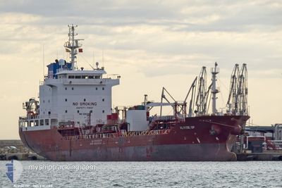
NQ LAELIA
Oil/Chemical Tanker

Current Trip
| Time Travelled | 1 day |
|---|---|
| Remaining Time | 4 h, 37 mins |
| Distance Travelled | 558.05 nm |
| Remaining Distance | 87.74 nm |
| AVG Speed | 11.7 Knop |
| MAX Speed | 13.6 Knop |
| AVG Wind | 8.8 knots |
| MAX Wind | 15 knots |
| MIN Temp | 12°C / 53.6°F |
| MAX Temp | 16.5°C / 61.7°F |
| Djupgående | 5.3 m |
| Position mottagen | 8 m sen |
Current Position
| Longitud | --- |
|---|---|
| Latitude | --- |
| Status | Under way using engine |
| Fart | 12.6 Knop |
| Kurs | 334.4° |
| Område | North Atlantic Ocean |
| Station | T-AIS |
| Position mottagen | 8 m sen |
Information
The current position of NQ LAELIA is in North Atlantic Ocean with coordinates 36.23181° / -6.50922° as reported on 2025-03-27 10:32 by AIS to our vessel tracker app. The vessel's current speed is 12.6 Knop and is heading at the port of HUELVA. The estimated time of arrival as calculated by MyShipTracking vessel tracking app is 2025-03-27 16:18 LT
The vessel NQ LAELIA (IMO: 9393383, MMSI: 249213000) is a Oil/Chemical Tanker that was built in 2008 ( 17 År gammal ). It's sailing under the flag of [MT] Malta.
In this page you can find informations about the vessels current position, last detected port calls, and current voyage information. If the vessels is not in coverage by AIS you will find the latest position.
The current position of NQ LAELIA is detected by our AIS receivers and we are not responsible for the reliability of the data. The last position was recorded while the vessel was in Coverage by the Ais receivers of our vessel tracking app.
The current draught of NQ LAELIA as reported by AIS is 5.3 meters
Weather
| Temperature | 15°C / 59°F |
|---|---|
| Wind Speed | 7 knots |
| Direction | 330° NNW |
| Pressure | 1018.4 hPa |
| Humidity | 77.5 % |
| Cloud Coverage | 17 % |


Featured Company
Last Port Calls
| Port | Arrival | Departure | Time In Port |
|---|---|---|---|
| 2025-03-24 16:22 | 2025-03-25 13:15 | 20 h | |
| 2025-03-22 15:53 | 2025-03-23 06:51 | 14 h | |
| 2025-03-18 20:27 | 2025-03-19 18:41 | 22 h | |
| 2025-03-12 14:42 | 2025-03-15 03:17 | 2 d | |
| 2025-03-06 18:33 | 2025-03-06 23:07 | 4 h | |
| 2025-03-02 15:53 | 2025-03-04 08:37 | 1 d | |
| 2025-02-27 15:56 | 2025-03-01 08:20 | 1 d | |
| 2025-02-23 13:10 | 2025-02-24 14:44 | 1 d | |
| 2025-02-17 05:18 | 2025-02-18 21:03 | 1 d | |
| 2025-02-01 09:31 | 2025-02-02 17:06 | 1 d |
Most Visited Ports (Last year)
| Port | Arrivals | |
|---|---|---|
| 13 | ||
| 9 | ||
| 8 | ||
| 8 | ||
| 5 | ||
| 5 |
Last Trips
| Origin | Departure | Destination | Arrival | Distance | |
|---|---|---|---|---|---|
| 2025-03-23 06:51 | 2025-03-24 16:22 | 411.80 nm | |||
| 2025-03-19 18:41 | 2025-03-22 15:53 | 354.17 nm | |||
| 2025-03-15 03:17 | 2025-03-18 20:27 | 162.00 nm | |||
| 2025-03-06 23:07 | 2025-03-12 14:42 | 344.48 nm | |||
| 2025-03-04 08:37 | 2025-03-06 18:33 | 704.23 nm | |||
| 2025-03-01 08:20 | 2025-03-02 15:53 | 282.07 nm | |||
| 2025-02-24 14:44 | 2025-02-27 15:56 | 394.31 nm | |||
| 2025-02-18 21:03 | 2025-02-23 13:10 | 1198.26 nm | |||
| 2025-02-02 17:06 | 2025-02-17 05:18 | 1793.82 nm | |||
| 2025-01-31 12:25 | 2025-02-01 09:31 | 262.62 nm |
Events
| Tid | Event | Detaljer | Position / Dest | Information |
|---|---|---|---|---|
| 2025-03-27 10:32 | Status ändrad | Under way using engine Default |
36.23181 / -6.50922
ESHUV
|
Fart: 12.6 kn Kurs: 335° |
| 2025-03-27 10:15 | I täckningsområde |
36.23181 / -6.50922
North Atlantic Ocean
ESHUV
|
Fart: 12.6 kn Kurs: 334.4° |
|
| 2025-03-27 08:42 | Status ändrad | Default Under way using engine |
35.96628 / -6.19427
ESHUV
|
Fart: 13.7 kn Kurs: 270.9° |
| 2025-03-27 08:37 | UTANFÖR täckningsområde |
35.96605 / -6.17361
North Atlantic Ocean
ESHUV
|
Fart: 13.7 kn Kurs: 270.9° |
|
| 2025-03-27 08:33 | Status ändrad | Under way using engine Default |
35.96550 / -6.15334
ESHUV
|
Fart: 13.4 kn Kurs: 272° |
| 2025-03-27 08:07 | Status ändrad | Default Under way using engine |
35.96278 / -6.03354
ESHUV
|
Fart: 13.5 kn Kurs: 271.4° |
| 2025-03-27 07:55 | Byter havsområde | Spanish part of the North Atlantic Ocean Spanish part of the Strait of Gibraltar |
35.96203 / -5.97990
North Atlantic Ocean
ESHUV
|
Fart: 13.4 kn Kurs: 270.4° |
| 2025-03-27 04:56 | Byter havsområde | Spanish part of the Strait of Gibraltar Gibraltarian part of the Strait of Gibraltar |
36.01982 / -5.33844
Strait of Gibraltar
ESHUV
|
Fart: 8 kn Kurs: 256.8° |
| 2025-03-27 04:53 | Byter havsområde | Gibraltarian part of the Strait of Gibraltar Gibraltarian part of the Alboran Sea |
36.02131 / -5.33047
Strait of Gibraltar
ESHUV
|
Fart: 7.9 kn Kurs: 256.7° |
| 2025-03-27 02:46 | Byter havsområde | Gibraltarian part of the Alboran Sea Spanish part of the Alboran Sea |
36.09008 / -4.92110
Alboran Sea
ESHUV
|
Fart: 11.4 kn Kurs: 252.6° |