
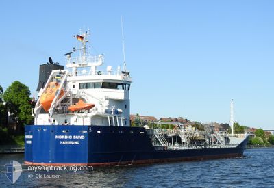
NORDIC SUND
Oil/Chemical Tanker
Current Trip
| Time Travelled | 1 day |
|---|---|
| Remaining Time | 1 h, 52 mins |
| Distance Travelled | 271.61 nm |
| Remaining Distance | 61.42 nm |
| AVG Speed | 8.9 Knop |
| MAX Speed | 14 Knop |
| AVG Wind | 18.6 knots |
| MAX Wind | 32.9 knots |
| MIN Temp | 12°C / 53.6°F |
| MAX Temp | 17.3°C / 63.14°F |
| Djupgående | 4.5 m |
| Position mottagen | 2 m sen |
Current Position
| Longitud | 3.35437° |
|---|---|
| Latitude | 51.80293° |
| Status | At anchor |
| Fart | 0.2 Knop |
| Kurs | 297° |
| Område | North Sea |
| Station | T-AIS |
| Position mottagen | 2 m sen |
Info
Information
The current position of NORDIC SUND is in North Sea with coordinates 51.80293° / 3.35437° as reported on 2024-07-06 22:46 by AIS to our vessel tracker app. The vessel's current speed is 0.2 Knop and is heading at the port of ANTWERP. The estimated time of arrival as calculated by MyShipTracking vessel tracking app is 2024-07-07 00:40 LT
The vessel NORDIC SUND (IMO: 9375977, MMSI: 258714000) is a Oil/Chemical Tanker that was built in 2007 ( 17 År gammal ). It's sailing under the flag of [NO] Norway.
In this page you can find informations about the vessels current position, last detected port calls, and current voyage information. If the vessels is not in coverage by AIS you will find the latest position.
The current position of NORDIC SUND is detected by our AIS receivers and we are not responsible for the reliability of the data. The last position was recorded while the vessel was in Coverage by the Ais receivers of our vessel tracking app.
The current draught of NORDIC SUND as reported by AIS is 4.5 meters
Weather
| Temperature | 15.3°C / 59.54°F |
|---|---|
| Wind Speed | 21 knots |
| Direction | 262° W |
| Pressure | 1008.5 hPa |
| Humidity | 71.9 % |
| Cloud Coverage | 5 % |
Featured Company
Last Port Calls
| Port | Arrival | Departure | Time In Port |
|---|---|---|---|
| 2024-07-04 12:38 | 2024-07-05 04:30 | 15 h | |
| 2024-06-30 09:25 | 2024-07-01 05:33 | 20 h | |
| 2024-06-26 19:18 | 2024-06-27 14:53 | 19 h | |
| 2024-06-21 08:22 | 2024-06-22 14:59 | 1 d | |
| 2024-06-18 13:58 | 2024-06-21 07:06 | 2 d | |
| 2024-06-15 23:07 | 2024-06-16 12:44 | 13 h | |
| 2024-06-12 04:19 | 2024-06-12 22:41 | 18 h | |
| 2024-06-09 18:59 | 2024-06-10 20:39 | 1 d | |
| 2024-06-07 01:36 | 2024-06-07 20:54 | 19 h | |
| 2024-05-30 13:40 | 2024-05-31 13:25 | 23 h |
Most Visited Ports (Last year)
| Port | Arrivals | |
|---|---|---|
| 10 | ||
| 7 | ||
| 7 | ||
| 6 | ||
| 6 | ||
| 4 |
Last Trips
| Origin | Departure | Destination | Arrival | Distance | |
|---|---|---|---|---|---|
| 2024-07-01 07:33 | 2024-07-04 13:38 | 655.45 nm | |||
| 2024-06-27 16:53 | 2024-06-30 11:25 | 267.67 nm | |||
| 2024-06-22 16:59 | 2024-06-26 21:18 | 635.04 nm | |||
| 2024-06-21 09:06 | 2024-06-21 10:22 | 9.49 nm | |||
| 2024-06-16 13:44 | 2024-06-18 15:58 | 414.32 nm | |||
| 2024-06-12 23:41 | 2024-06-16 00:07 | 170.07 nm | |||
| 2024-06-10 21:39 | 2024-06-12 05:19 | 232.92 nm | |||
| 2024-06-07 22:54 | 2024-06-09 19:59 | 357.95 nm | |||
| 2024-05-31 15:25 | 2024-06-07 03:36 | 1282.50 nm | |||
| 2024-05-23 07:27 | 2024-05-30 15:40 | 1641.75 nm |
Events
| Tid | Event | Detaljer | Position / Dest | Information |
|---|---|---|---|---|
| 2024-07-06 17:48 | Status ändrad | At anchor Default |
51.80460 / 3.35459
GB DAG>BE ANR
|
Fart: 0.1 kn Kurs: 241° |
| 2024-07-06 17:43 | Status ändrad | Default At anchor |
51.80465 / 3.35460
GB DAG>BE ANR
|
Fart: 0.1 kn Kurs: 241° |
| 2024-07-06 14:00 | Status ändrad | At anchor Under way using engine |
51.80338 / 3.34967
GB DAG>BE ANR
|
Fart: 1.7 kn Kurs: 237° |
| 2024-07-06 13:55 | STOPPAR förflyttning | 16.94 nm, North West of NEELTJE JANS |
51.80259 / 3.34628
GB DAG>BE ANR
|
Fart: 0.2 kn Kurs: 241° |
| 2024-07-06 13:17 | STARTAR förflyttning | 16.79 nm, North West of BURGHSLUIS |
51.83270 / 3.38520
GB DAG>BE ANR
|
Fart: 4.9 kn Kurs: 177° |
| 2024-07-06 13:08 | STOPPAR förflyttning | 16.87 nm, North West of BURGHSLUIS |
51.83454 / 3.38465
GB DAG>BE ANR
|
Fart: 0.2 kn Kurs: 237° |
| 2024-07-06 12:55 | STARTAR förflyttning | 16.29 nm, North West of BURGHSLUIS |
51.83213 / 3.40077
GB DAG>BE ANR
|
Fart: 3.2 kn Kurs: 272° |
| 2024-07-06 12:50 | Status ändrad | Under way using engine At anchor |
51.83146 / 3.39907
GB DAG>BE ANR
|
Fart: 0.9 kn Kurs: 265° |
| 2024-07-06 06:57 | Status ändrad | At anchor Under way using engine |
51.82824 / 3.38834
GB DAG>BE ANR
|
Fart: 0.2 kn Kurs: 185° |
| 2024-07-06 06:41 | STOPPAR förflyttning | 16.54 nm, North West of BURGHSLUIS |
51.82684 / 3.38701
GB DAG>BE ANR
|
Fart: 0.3 kn Kurs: 215° |