
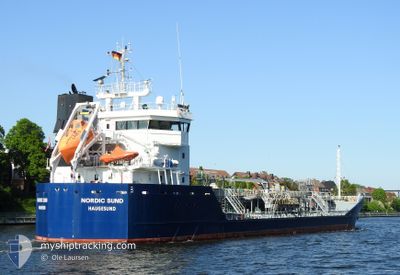
NORDIC SUND
Oil/Chemical Tanker
Current Trip
| Time Travelled | 1 day |
|---|---|
| Remaining Time | --- |
| Distance Travelled | 255.94 nm |
| Remaining Distance | --- |
| AVG Speed | 10.2 Noeuds |
| MAX Speed | 11.7 Noeuds |
| AVG Wind | 11.5 knots |
| MAX Wind | 14.8 knots |
| MIN Temp | 2.8°C / 37.04°F |
| MAX Temp | 5.4°C / 41.72°F |
| Tirant d eau | 4.6 m |
| Position reçue | 8 h, 13 m depuis |
Current Position
| Longitude | --- |
|---|---|
| Latitude | --- |
| Etat | Under way using engine |
| Vitesse | 10.7 Noeuds |
| Parcours | 208.8° |
| Zone | North Sea |
| Station | T-AIS |
| Position reçue | 8 h, 13 m depuis |
Info
Information
The current position of NORDIC SUND is in North Sea with coordinates 56.01154° / 6.30290° as reported on 2025-02-27 09:47 by AIS to our vessel tracker app. The vessel's current speed is 10.7 Noeuds and is heading at the port of STADE. The estimated time of arrival as calculated by MyShipTracking vessel tracking app is 2025-02-28 01:30 LT
The vessel NORDIC SUND (IMO: 9375977, MMSI: 258714000) is a Oil/Chemical Tanker that was built in 2007 ( 18 Age ). It's sailing under the flag of [NO] Norway.
In this page you can find informations about the vessels current position, last detected port calls, and current voyage information. If the vessels is not in coverage by AIS you will find the latest position.
The current position of NORDIC SUND is detected by our AIS receivers and we are not responsible for the reliability of the data. The last position was recorded while the vessel was in Coverage by the Ais receivers of our vessel tracking app.
The current draught of NORDIC SUND as reported by AIS is 4.6 meters
Weather
| Temperature | 4.2°C / 39.56°F |
|---|---|
| Wind Speed | 16 knots |
| Direction | 48° NE |
| Pressure | 1015.2 hPa |
| Humidity | 96.8 % |
| Cloud Coverage | 100 % |
Featured Company
Last Port Calls
| Port | Arrival | Departure | Time In Port |
|---|---|---|---|
| 2025-02-25 17:03 | 2025-02-26 10:08 | 17 h | |
| 2025-02-18 18:04 | 2025-02-20 15:02 | 1 d | |
| 2025-02-15 01:24 | 2025-02-15 03:03 | 1 h | |
| 2025-02-12 14:11 | 2025-02-13 19:16 | 1 d | |
| 2025-02-06 16:57 | 2025-02-07 18:29 | 1 d | |
| 2025-02-05 06:57 | 2025-02-05 20:33 | 13 h | |
| 2025-02-01 01:41 | 2025-02-02 22:53 | 1 d | |
| 2025-01-30 00:06 | 2025-01-30 22:50 | 22 h | |
| 2025-01-25 23:16 | 2025-01-26 23:19 | 1 d | |
| 2025-01-22 21:20 | 2025-01-23 20:50 | 23 h |
Most Visited Ports (Last year)
| Port | Arrivals | |
|---|---|---|
| 11 | ||
| 8 | ||
| 7 | ||
| 6 | ||
| 5 | ||
| 5 |
Last Trips
| Origin | Departure | Destination | Arrival | Distance | |
|---|---|---|---|---|---|
| 2025-02-20 15:02 | 2025-02-25 17:03 | 745.90 nm | |||
| 2025-02-15 03:03 | 2025-02-18 18:04 | 284.72 nm | |||
| 2025-02-13 19:16 | 2025-02-15 01:24 | 302.27 nm | |||
| 2025-02-07 18:29 | 2025-02-12 14:11 | 593.63 nm | |||
| 2025-02-05 20:33 | 2025-02-06 16:57 | 191.78 nm | |||
| 2025-02-02 22:53 | 2025-02-05 06:57 | 520.45 nm | |||
| 2025-01-30 22:50 | 2025-02-01 01:41 | 239.02 nm | |||
| 2025-01-26 23:19 | 2025-01-30 00:06 | 205.71 nm | |||
| 2025-01-23 20:50 | 2025-01-25 23:16 | 393.83 nm | |||
| 2025-01-21 10:12 | 2025-01-22 21:20 | 350.15 nm |
Events
| Heure | Evenement | Détails | Position/ Destination | Info |
|---|---|---|---|---|
| 2025-02-27 09:54 | Etat Changé | Default Under way using engine |
55.99251 / 6.28511
STADE
|
Vitesse: 10.7 kn Parcours: 208.8° |
| 2025-02-27 09:47 | Hors de la zone couverte |
56.01154 / 6.30290
North Sea
STADE
|
Vitesse: 10.7 kn Parcours: 208.8° |
|
| 2025-02-27 09:46 | Etat Changé | Under way using engine Default |
56.01548 / 6.30657
STADE
|
Vitesse: 10.6 kn Parcours: 207° |
| 2025-02-27 09:46 | Dans la zone couverte |
56.01333 / 6.30459
North Sea
STADE
|
Vitesse: 10.7 kn Parcours: 206° |
|
| 2025-02-27 08:48 | Etat Changé | Default Under way using engine |
56.15579 / 6.47542
STADE
|
Vitesse: 11 kn Parcours: 212.6° |
| 2025-02-27 08:41 | Hors de la zone couverte |
56.17334 / 6.49538
North Sea
STADE
|
Vitesse: 11 kn Parcours: 212.6° |
|
| 2025-02-27 08:35 | Etat Changé | Under way using engine Default |
56.18892 / 6.51286
STADE
|
Vitesse: 11.2 kn Parcours: 212° |
| 2025-02-27 08:24 | Etat Changé | Default Under way using engine |
56.21806 / 6.54594
STADE
|
Vitesse: 11 kn Parcours: 212.3° |
| 2025-02-27 00:04 | Changement de zone | Danish part of the North Sea Danish part of the Skaggerak |
57.41150 / 8.05854
North Sea
STADE
|
Vitesse: 9.9 kn Parcours: 223.7° |
| 2025-02-26 22:29 | Detecté en mer | Danish part of the Skaggerak |
57.60061 / 8.39778
Skaggerak
STADE
|
Vitesse: 10.2 kn Parcours: 222.1° |