
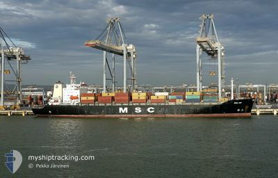
MSC JOY
Container Ship
Current Trip
| Time Travelled | 6 days |
|---|---|
| Remaining Time | 19 h, 45 mins |
| Distance Travelled | 1338.77 nm |
| Remaining Distance | 243.94 nm |
| AVG Speed | 10.9 Knop |
| MAX Speed | 17.7 Knop |
| AVG Wind | 10.9 knots |
| MAX Wind | 24.8 knots |
| MIN Temp | 6.3°C / 43.34°F |
| MAX Temp | 16.4°C / 61.52°F |
| Djupgående | 7.8 m |
| Position mottagen | 1 h, 17 m sen |
Current Position
| Longitud | --- |
|---|---|
| Latitude | --- |
| Status | Under way using engine |
| Fart | 11 Knop |
| Kurs | 261.8° |
| Område | Strait of Gibraltar |
| Station | T-AIS |
| Position mottagen | 1 h, 17 m sen |
Info
Information
The current position of MSC JOY is in Strait of Gibraltar with coordinates 35.95017° / -5.78302° as reported on 2025-03-17 17:15 by AIS to our vessel tracker app. The vessel's current speed is 11 Knop and is heading at the port of SINES. The estimated time of arrival as calculated by MyShipTracking vessel tracking app is 2025-03-18 14:17 LT
The vessel MSC JOY (IMO: 9039250, MMSI: 356037000) is a Container Ship that was built in 1992 ( 33 År gammal ). It's sailing under the flag of [PA] Panama.
In this page you can find informations about the vessels current position, last detected port calls, and current voyage information. If the vessels is not in coverage by AIS you will find the latest position.
The current position of MSC JOY is detected by our AIS receivers and we are not responsible for the reliability of the data. The last position was recorded while the vessel was in Coverage by the Ais receivers of our vessel tracking app.
The current draught of MSC JOY as reported by AIS is 7.8 meters
Weather
| Temperature | 16.2°C / 61.16°F |
|---|---|
| Wind Speed | 25 knots |
| Direction | 206° SSW |
| Pressure | 1010.2 hPa |
| Humidity | 80 % |
| Cloud Coverage | 66 % |
Featured Company
Last Port Calls
| Port | Arrival | Departure | Time In Port |
|---|---|---|---|
| 2025-03-10 04:12 | 2025-03-11 17:36 | 1 d | |
| 2025-03-05 08:21 | 2025-03-06 12:59 | 1 d | |
| 2025-03-02 08:19 | 2025-03-03 23:17 | 1 d | |
| 2025-02-27 10:38 | 2025-02-28 11:28 | 1 d | |
| 2025-02-13 20:35 | 2025-02-25 07:06 | 11 d | |
| 2025-02-09 18:12 | 2025-02-11 16:44 | 1 d | |
| 2025-02-04 11:25 | 2025-02-07 19:27 | 3 d | |
| 2025-01-29 00:22 | 2025-01-31 07:59 | 2 d | |
| 2025-01-26 05:27 | 2025-01-26 13:10 | 7 h | |
| 2025-01-22 19:30 | 2025-01-24 12:36 | 1 d |
Last Trips
| Origin | Departure | Destination | Arrival | Distance | |
|---|---|---|---|---|---|
| 2025-03-06 12:59 | 2025-03-10 04:12 | 425.99 nm | |||
| 2025-03-03 23:17 | 2025-03-05 08:21 | 402.88 nm | |||
| 2025-02-28 11:28 | 2025-03-02 08:19 | 213.36 nm | |||
| 2025-02-25 07:06 | 2025-02-27 10:38 | 708.93 nm | |||
| 2025-02-11 16:44 | 2025-02-13 20:35 | 752.06 nm | |||
| 2025-02-07 19:27 | 2025-02-09 18:12 | 721.73 nm | |||
| 2025-01-31 07:59 | 2025-02-04 11:25 | 669.79 nm | |||
| 2025-01-26 13:10 | 2025-01-29 00:22 | 542.28 nm | |||
| 2025-01-24 12:36 | 2025-01-26 05:27 | 530.49 nm | |||
| 2025-01-20 16:57 | 2025-01-22 19:30 | 508.76 nm |
Events
| Tid | Event | Detaljer | Position / Dest | Information |
|---|---|---|---|---|
| 2025-03-17 17:20 | Status ändrad | Default Under way using engine |
35.94774 / -5.80145
FRLEH>PTSIE
|
Fart: 11 kn Kurs: 261.8° |
| 2025-03-17 17:15 | Status ändrad | Under way using engine Default |
35.95017 / -5.78302
FRLEH>PTSIE
|
Fart: 11 kn Kurs: 261° |
| 2025-03-17 17:15 | UTANFÖR täckningsområde |
35.95017 / -5.78302
Strait of Gibraltar
FRLEH>PTSIE
|
Fart: 11 kn Kurs: 261.8° |
|
| 2025-03-17 17:04 | Status ändrad | Default Under way using engine |
35.95563 / -5.74209
FRLEH>PTSIE
|
Fart: 10.9 kn Kurs: 258.1° |
| 2025-03-17 16:53 | Status ändrad | Under way using engine Default |
35.96084 / -5.70132
FRLEH>PTSIE
|
Fart: 11.2 kn Kurs: 260° |
| 2025-03-17 16:52 | Status ändrad | Default Under way using engine |
35.96139 / -5.69755
FRLEH>PTSIE
|
Fart: 11.1 kn Kurs: 264.7° |
| 2025-03-17 15:05 | Byter havsområde | Spanish part of the Strait of Gibraltar Gibraltarian part of the Strait of Gibraltar |
36.02216 / -5.34410
Strait of Gibraltar
FRLEH>PTSIE
|
Fart: 7.4 kn Kurs: 233.1° |
| 2025-03-17 14:58 | Byter havsområde | Gibraltarian part of the Strait of Gibraltar Gibraltarian part of the Alboran Sea |
36.03172 / -5.33071
Strait of Gibraltar
FRLEH>PTSIE
|
Fart: 7.3 kn Kurs: 231.8° |
| 2025-03-17 13:51 | ETA ändrat | 2025/03/18 16:00 2025/03/18 16:30 |
36.11450 / -5.14180
FRLEH>PTSIE
|
Fart: 13.9 kn Kurs: 233.7° |
| 2025-03-17 13:46 | Byter havsområde | Gibraltarian part of the Alboran Sea Spanish part of the Alboran Sea |
36.12841 / -5.11817
Alboran Sea
FRLEH>PTSIE
|
Fart: 16.4 kn Kurs: 232.4° |