

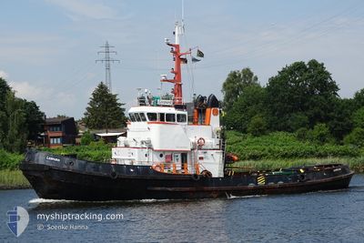
LEOPARD
Tug

Current Trip
| Trip Time | 3 days |
|---|---|
| Trip Distance | 703.97 nm |
| AVG Speed | 7.7 Knop |
| MAX Speed | 11 Knop |
| Djupgående | 4.6 m |
| AVG Wind | 10.6 knots |
| MAX Wind | 25 knots |
| MIN Temp | 1.3°C / 34.34°F |
| MAX Temp | 8.4°C / 47.12°F |
| Position mottagen | 1 m sen |
Current Position
| Longitud | --- |
|---|---|
| Latitude | --- |
| Status | Under way using engine |
| Fart | |
| Kurs | 293° |
| Område | Baltic Sea |
| Station | T-AIS |
| Position mottagen | 1 m sen |
Information
The current position of LEOPARD is in Baltic Sea with coordinates 54.53654° / 18.53152° as reported on 2025-02-13 04:47 by AIS to our vessel tracker app. The vessel's current speed is 0 Knop and is currently inside the port of GDYNIA.
The vessel LEOPARD (IMO: 6819697, MMSI: 576909000) is a Tug that was built in 1969 ( 56 År gammal ). It's sailing under the flag of [VU] Vanuatu.
In this page you can find informations about the vessels current position, last detected port calls, and current voyage information. If the vessels is not in coverage by AIS you will find the latest position.
The current position of LEOPARD is detected by our AIS receivers and we are not responsible for the reliability of the data. The last position was recorded while the vessel was in Coverage by the Ais receivers of our vessel tracking app.
The current draught of LEOPARD as reported by AIS is 4.6 meters
Weather
| Temperature | -1.7°C / 28.94°F |
|---|---|
| Wind Speed | 5 knots |
| Direction | 136° SE |
| Pressure | 1021.2 hPa |
| Humidity | 52.6 % |
| Cloud Coverage | 97 % |


Featured Company
Last Port Calls
| Port | Arrival | Departure | Time In Port |
|---|---|---|---|
| 2025-02-07 16:25 | |||
| 2025-02-03 12:00 | 2025-02-03 20:20 | 8 h | |
| 2025-01-22 15:43 | 2025-02-01 09:24 | 9 d | |
| 2024-12-23 06:21 | 2025-01-19 07:30 | 27 d | |
| 2024-12-14 08:30 | 2024-12-21 13:46 | 7 d | |
| 2024-12-12 09:49 | 2024-12-13 13:24 | 1 d | |
| 2024-12-03 01:42 | 2024-12-10 20:34 | 7 d | |
| 2024-12-02 00:21 | 2024-12-02 14:37 | 14 h | |
| 2024-12-01 23:18 |
Most Visited Ports (Last year)
| Port | Arrivals | |
|---|---|---|
| 13 | ||
| 7 | ||
| 5 | ||
| 4 | ||
| 4 | ||
| 3 |
Last Trips
| Origin | Departure | Destination | Arrival | Distance | |
|---|---|---|---|---|---|
| 2025-02-03 21:20 | 2025-02-07 17:25 | 703.97 nm | |||
| 2025-02-01 10:24 | 2025-02-03 13:00 | 259.77 nm | |||
| 2025-01-19 08:30 | 2025-01-22 16:43 | 557.21 nm | |||
| 2024-12-21 14:46 | 2024-12-23 07:21 | 194.27 nm | |||
| 2024-12-13 14:24 | 2024-12-14 09:30 | 119.93 nm | |||
| 2024-12-10 21:34 | 2024-12-12 10:49 | 211.28 nm | |||
| 2024-12-02 15:37 | 2024-12-03 02:42 | 76.34 nm | |||
| 2024-11-30 19:00 | 2024-12-02 01:21 | 278.71 nm | |||
| 2024-11-30 19:00 | 2024-12-02 00:18 | 278.26 nm |
Events
| Tid | Event | Detaljer | Position / Dest | Information |
|---|---|---|---|---|
| 2025-02-07 16:37 | STOPPAR förflyttning |
54.53656 / 18.53162
[PL] GDYNIA
|
Fart: Kurs: 308° |
|
| 2025-02-07 16:25 | ANLÄNDER HAMN |
|
54.53585 / 18.56323
[PL] GDYNIA
|
Fart: 6.9 kn Kurs: 272.6° |
| 2025-02-07 12:12 | Status ändrad | Under way using engine Default |
54.86721 / 18.36578
PL GDY
|
Fart: 8.6 kn Kurs: 123° |
| 2025-02-07 11:54 | Status ändrad | Default Under way using engine |
54.88798 / 18.30157
PL GDY
|
Fart: 8.4 kn Kurs: 87.4° |
| 2025-02-07 11:42 | Status ändrad | Under way using engine Default |
54.88609 / 18.25052
PL GDY
|
Fart: 8.6 kn Kurs: 90° |
| 2025-02-07 11:42 | I täckningsområde |
54.88632 / 18.25668
Baltic Sea
PL GDY
|
Fart: 8.6 kn Kurs: 86.6° |
|
| 2025-02-07 01:31 | UTANFÖR täckningsområde |
54.68465 / 15.69590
Baltic Sea
PL GDY
|
Fart: 8.8 kn Kurs: 83.6° |
|
| 2025-02-06 22:17 | Byter havsområde | Polish part of the Baltic Sea Danish part of the Kattegat |
54.63052 / 14.85775
Baltic Sea
PL GDY
|
Fart: 9.4 kn Kurs: 77.7° |
| 2025-02-06 21:02 | Byter havsområde | Danish part of the Kattegat German part of the Baltic Sea |
54.60351 / 14.52720
Kattegat
PL GDY
|
Fart: 9.1 kn Kurs: 82.6° |
| 2025-02-06 19:28 | Status ändrad | Under way using engine Default |
54.63841 / 14.13207
PL GDY
|
Fart: 9.2 kn Kurs: 106° |