
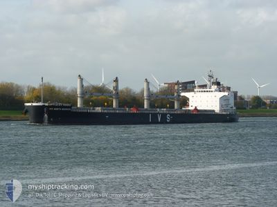
IVS NORTH BERWICK
Cargo
Current Trip
| Time Travelled | 2 days |
|---|---|
| Remaining Time | 2 days |
| Distance Travelled | 612.02 nm |
| Remaining Distance | 414.54 nm |
| AVG Speed | 10.1 Knop |
| MAX Speed | 13 Knop |
| AVG Wind | 27.8 knots |
| MAX Wind | 42 knots |
| MIN Temp | 7.6°C / 45.68°F |
| MAX Temp | 14.7°C / 58.46°F |
| Djupgående | 10.4 m |
| Position mottagen | 1 m sen |
Current Position
| Longitud | --- |
|---|---|
| Latitude | --- |
| Status | Under way using engine |
| Fart | 5.6 Knop |
| Kurs | 0.6° |
| Område | Norwegian Sea |
| Station | T-AIS |
| Position mottagen | 1 m sen |
Info
Information
The current position of IVS NORTH BERWICK is in Norwegian Sea with coordinates 61.55279° / 4.19077° as reported on 2024-11-26 09:08 by AIS to our vessel tracker app. The vessel's current speed is 5.6 Knop and is heading at the port of MOIRANA. The estimated time of arrival as calculated by MyShipTracking vessel tracking app is 2024-11-29 00:55 LT
The vessel IVS NORTH BERWICK (IMO: 9740902, MMSI: 563850000) is a Cargo It's sailing under the flag of [SG] Singapore.
In this page you can find informations about the vessels current position, last detected port calls, and current voyage information. If the vessels is not in coverage by AIS you will find the latest position.
The current position of IVS NORTH BERWICK is detected by our AIS receivers and we are not responsible for the reliability of the data. The last position was recorded while the vessel was in Coverage by the Ais receivers of our vessel tracking app.
The current draught of IVS NORTH BERWICK as reported by AIS is 10.4 meters
Weather
| Temperature | 8.1°C / 46.58°F |
|---|---|
| Wind Speed | 7 knots |
| Direction | 339° NNW |
| Pressure | 992.6 hPa |
| Humidity | 84.6 % |
| Cloud Coverage | 100 % |
Featured Company
Last Port Calls
| Port | Arrival | Departure | Time In Port |
|---|---|---|---|
| 2024-11-21 06:09 | 2024-11-24 01:52 | 2 d | |
| 2024-11-17 02:48 | 2024-11-18 02:46 | 23 h | |
| 2024-10-15 13:08 | 2024-10-23 22:14 | 8 d | |
| 2024-09-22 12:08 | 2024-09-26 08:04 | 3 d | |
| 2024-09-07 07:28 | 2024-09-08 08:00 | 1 d | |
| 2024-09-02 14:16 |
Most Visited Ports (Last year)
| Port | Arrivals | |
|---|---|---|
| 6 | ||
| 6 | ||
| 3 | ||
| 3 | ||
| 1 | ||
| 1 |
Last Trips
| Origin | Departure | Destination | Arrival | Distance | |
|---|---|---|---|---|---|
| 2024-11-18 02:46 | 2024-11-21 06:09 | 792.78 nm | |||
| 2024-10-23 22:14 | 2024-11-17 02:48 | 6256.13 nm | |||
| 2024-09-26 08:04 | 2024-10-15 13:08 | 4377.16 nm | |||
| 2024-09-08 08:00 | 2024-09-22 12:08 | 4085.60 nm | |||
| 2024-09-02 14:16 | 2024-09-07 07:28 | 1323.54 nm |
Events
| Tid | Event | Detaljer | Position / Dest | Information |
|---|---|---|---|---|
| 2024-11-26 05:07 | Byter havsområde | Norwegian part of the Norwegian Sea Norwegian part of the North Sea |
61.00518 / 4.18739
Norwegian Sea
NO MQN
|
Fart: 9.3 kn Kurs: 6.4° |
| 2024-11-26 01:51 | Djupgående ändrat | 10.4 9.9 |
60.43816 / 4.21268
NO MQN
|
Fart: 11.1 kn Kurs: 9.6° |
| 2024-11-25 04:44 | Byter havsområde | Norwegian part of the North Sea Danish part of the North Sea |
56.74886 / 5.49760
North Sea
NO MQN
|
Fart: 11.2 kn Kurs: 344.2° |
| 2024-11-25 04:28 | Status ändrad | Under way using engine Default |
56.70190 / 5.52781
NO MQN
|
Fart: 11.8 kn Kurs: 358° |
| 2024-11-25 04:12 | Status ändrad | Default Under way using engine |
56.65291 / 5.55005
NO MQN
|
Fart: 11.8 kn Kurs: 358.6° |
| 2024-11-25 03:45 | Status ändrad | Under way using engine Default |
56.56415 / 5.55227
NO MQN
|
Fart: 11.7 kn Kurs: 357° |
| 2024-11-25 03:26 | Status ändrad | Default Under way using engine |
56.50324 / 5.55490
NO MQN
|
Fart: 11.9 kn Kurs: 359.1° |
| 2024-11-25 03:13 | Status ändrad | Under way using engine Default |
56.45920 / 5.55612
NO MQN
|
Fart: 12.1 kn Kurs: 359° |
| 2024-11-25 02:58 | Status ändrad | Default Under way using engine |
56.40876 / 5.55832
NO MQN
|
Fart: 11.9 kn Kurs: 358.1° |
| 2024-11-25 01:30 | Status ändrad | Under way using engine Default |
56.12098 / 5.59786
NO MQN
|
Fart: 11.1 kn Kurs: 358° |