
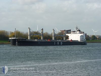
IVS NORTH BERWICK
Cargo
Current Trip
| Time Travelled | --- |
|---|---|
| Remaining Time | --- |
| Distance Travelled | 10344.82 nm |
| Remaining Distance | --- |
| AVG Speed | 10.9 Noeuds |
| MAX Speed | 15.9 Noeuds |
| AVG Wind | 22.2 knots |
| MAX Wind | 42.9 knots |
| MIN Temp | 5°C / 41°F |
| MAX Temp | 28.1°C / 82.58°F |
| Tirant d eau | 13.3 m |
| Position reçue | 8 d depuis |
Current Position
| Longitude | --- |
|---|---|
| Latitude | --- |
| Etat | Under way using engine |
| Vitesse | 10.6 Noeuds |
| Parcours | 113.9° |
| Zone | Caribbean Sea |
| Station | T-AIS |
| Position reçue | 8 d depuis |
Info
Information
The current position of IVS NORTH BERWICK is in Caribbean Sea with coordinates 14.08746° / -60.47268° as reported on 2025-03-09 14:32 by AIS to our vessel tracker app. The vessel's current speed is 10.6 Noeuds and is heading at the port of PORT QASIM. The estimated time of arrival as calculated by MyShipTracking vessel tracking app is 2025-04-20 12:00 LT
The vessel IVS NORTH BERWICK (IMO: 9740902, MMSI: 563850000) is a Cargo It's sailing under the flag of [SG] Singapore.
In this page you can find informations about the vessels current position, last detected port calls, and current voyage information. If the vessels is not in coverage by AIS you will find the latest position.
The current position of IVS NORTH BERWICK is detected by our AIS receivers and we are not responsible for the reliability of the data. The last position was recorded while the vessel was in Coverage by the Ais receivers of our vessel tracking app.
The current draught of IVS NORTH BERWICK as reported by AIS is 13.3 meters
Weather
| Temperature | 27.2°C / 80.96°F |
|---|---|
| Wind Speed | 11 knots |
| Direction | 102° ESE |
| Pressure | 1012.7 hPa |
| Humidity | 63.7 % |
| Cloud Coverage | 98 % |
Featured Company
Last Port Calls
Most Visited Ports (Last year)
| Port | Arrivals | |
|---|---|---|
| 5 | ||
| 4 | ||
| 3 | ||
| 2 | ||
| 1 | ||
| 1 |
Last Trips
| Origin | Departure | Destination | Arrival | Distance |
|---|
Events
| Heure | Evenement | Détails | Position/ Destination | Info |
|---|---|---|---|---|
| 2025-03-09 14:35 | Etat Changé | Default Under way using engine |
14.08345 / -60.46400
PK BQM
|
Vitesse: 10.6 kn Parcours: 113.9° |
| 2025-03-09 14:32 | Hors de la zone couverte |
14.08746 / -60.47268
Caribbean Sea
|
Vitesse: 10.6 kn Parcours: 113.9° |
|
| 2025-03-09 14:32 | Etat Changé | Under way using engine Default |
14.08746 / -60.47268
PK BQM
|
Vitesse: 10.7 kn Parcours: 114° |
| 2025-03-09 14:15 | Dans la zone couverte |
14.08746 / -60.47268
Caribbean Sea
|
Vitesse: 10.6 kn Parcours: 113.9° |
|
| 2025-03-09 13:36 | Etat Changé | Default Under way using engine |
14.15531 / -60.63243
PK BQM
|
Vitesse: 10.5 kn Parcours: 112.6° |
| 2025-03-09 13:30 | Hors de la zone couverte |
14.16141 / -60.64672
Caribbean Sea
|
Vitesse: 10.5 kn Parcours: 112.6° |
|
| 2025-03-09 13:30 | Etat Changé | Under way using engine Default |
14.16179 / -60.64763
PK BQM
|
Vitesse: 10.4 kn Parcours: 112° |
| 2025-03-09 12:58 | Etat Changé | Default Under way using engine |
14.20369 / -60.73407
PK BQM
|
Vitesse: 10.6 kn Parcours: 114.8° |
| 2025-03-09 12:43 | Detecté en mer | Saint Lucia part of the Caribbean Sea |
14.22231 / -60.77378
Caribbean Sea
|
Vitesse: 10.4 kn Parcours: 114.1° |
| 2025-03-09 07:06 | Detecté en mer | Guadeloupe and Martinique part of the Caribbean Sea |
14.60018 / -61.74386
Caribbean Sea
|
Vitesse: 10.2 kn Parcours: 113.1° |