
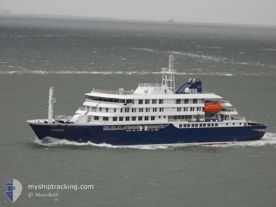
HONDIUS
Passenger
Current Trip
NOLYR
| Time Travelled | 2 days |
|---|---|
| Remaining Time | --- |
| Distance Travelled | 819.68 nm |
| Remaining Distance | --- |
| AVG Speed | 11.6 Knop |
| MAX Speed | 14.1 Knop |
| AVG Wind | 14.9 knots |
| MAX Wind | 21.8 knots |
| MIN Temp | 8.6°C / 47.48°F |
| MAX Temp | 17.6°C / 63.68°F |
| Djupgående | 5.4 m |
| Position mottagen | 1 h, 46 m sen |
Current Position
| Longitud | 4.11230° |
|---|---|
| Latitude | 63.68623° |
| Status | Under way using engine |
| Fart | 13.2 Knop |
| Kurs | 28° |
| Område | Norwegian Sea |
| Station | T-AIS |
| Position mottagen | 1 h, 46 m sen |
Info
Information
The current position of HONDIUS is in Norwegian Sea with coordinates 63.68623° / 4.11230° as reported on 2024-06-06 09:58 by AIS to our vessel tracker app. The vessel's current speed is 13.2 Knop
The vessel HONDIUS (IMO: 9818709, MMSI: 244327000) is a Passenger It's sailing under the flag of [NL] Netherlands.
In this page you can find informations about the vessels current position, last detected port calls, and current voyage information. If the vessels is not in coverage by AIS you will find the latest position.
The current position of HONDIUS is detected by our AIS receivers and we are not responsible for the reliability of the data. The last position was recorded while the vessel was in Coverage by the Ais receivers of our vessel tracking app.
The current draught of HONDIUS as reported by AIS is 5.4 meters
Weather
| Temperature | 9.3°C / 48.74°F |
|---|---|
| Wind Speed | 14 knots |
| Direction | 202° SSW |
| Pressure | 1001 hPa |
| Humidity | 63.7 % |
| Cloud Coverage | 95 % |
Featured Company
Last Port Calls
| Port | Arrival | Departure | Time In Port |
|---|---|---|---|
| 2024-05-10 10:59 | 2024-06-03 15:06 | 24 d |
Most Visited Ports (Last year)
| Port | Arrivals | |
|---|---|---|
| 10 | ||
| 2 | ||
| 2 | ||
| 1 | ||
| 1 |
Last Trips
| Origin | Departure | Destination | Arrival | Distance | |
|---|---|---|---|---|---|
| 2024-03-29 07:13 | 2024-05-10 12:59 | 8248.67 nm |
Events
| Tid | Event | Detaljer | Position / Dest | Information |
|---|---|---|---|---|
| 2024-06-06 09:58 | UTANFÖR täckningsområde |
63.68623 / 4.11230
Norwegian Sea
NOLYR
|
Fart: 13.2 kn Kurs: 28° |
|
| 2024-06-05 20:22 | Byter havsområde | Norwegian part of the Norwegian Sea Norwegian part of the North Sea |
61.00213 / 3.24724
Norwegian Sea
NOLYR
|
Fart: 11.7 kn Kurs: 0.6° |
| 2024-06-05 10:00 | Status ändrad | Under way using engine Default |
59.02346 / 3.30331
NOLYR
|
Fart: 11.6 kn Kurs: 343° |
| 2024-06-05 10:00 | I täckningsområde |
59.02346 / 3.30331
North Sea
NOLYR
|
Fart: 11.5 kn Kurs: 342.6° |
|
| 2024-06-05 07:42 | Status ändrad | Default Under way using engine |
58.62270 / 3.58019
NOLYR
|
Fart: 10.8 kn Kurs: 340.6° |
| 2024-06-05 07:32 | UTANFÖR täckningsområde |
58.59300 / 3.60047
North Sea
NOLYR
|
Fart: 10.8 kn Kurs: 340.6° |
|
| 2024-06-05 07:13 | I täckningsområde |
58.53977 / 3.63567
North Sea
NOLYR
|
Fart: 10.6 kn Kurs: 341.6° |
|
| 2024-06-05 06:04 | UTANFÖR täckningsområde |
58.34192 / 3.78098
North Sea
NOLYR
|
Fart: 10.4 kn Kurs: 335.9° |
|
| 2024-06-05 05:03 | Status ändrad | Under way using engine Default |
58.18017 / 3.91521
NOLYR
|
Fart: 10.8 kn Kurs: 341° |
| 2024-06-05 04:58 | I täckningsområde |
58.18017 / 3.91521
North Sea
NOLYR
|
Fart: 10.6 kn Kurs: 341.3° |