
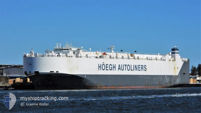
HOEGH ST. PETERSBURG
Vehicles Carrier
Current Trip
| Time Travelled | 9 days |
|---|---|
| Remaining Time | --- |
| Distance Travelled | 3856.90 nm |
| Remaining Distance | --- |
| AVG Speed | 17.1 Knop |
| MAX Speed | 18.9 Knop |
| AVG Wind | 14.9 knots |
| MAX Wind | 32.3 knots |
| MIN Temp | 19.7°C / 67.46°F |
| MAX Temp | 26.5°C / 79.7°F |
| Djupgående | 9.2 m |
| Position mottagen | 5 d sen |
Current Position
| Longitud | -17.89042° |
|---|---|
| Latitude | 24.34369° |
| Status | Under way using engine |
| Fart | 17.2 Knop |
| Kurs | 199.1° |
| Område | North Atlantic Ocean |
| Station | T-AIS |
| Position mottagen | 5 d sen |
Info
Information
The current position of HOEGH ST. PETERSBURG is in North Atlantic Ocean with coordinates 24.34369° / -17.89042° as reported on 2024-08-13 13:10 by AIS to our vessel tracker app. The vessel's current speed is 17.2 Knop and is heading at the port of PORT ELIZABETH. The estimated time of arrival as calculated by MyShipTracking vessel tracking app is 2024-08-26 00:01 LT
The vessel HOEGH ST. PETERSBURG (IMO: 9420045, MMSI: 257366000) is a Vehicles Carrier that was built in 2009 ( 15 År gammal ). It's sailing under the flag of [NO] Norway.
In this page you can find informations about the vessels current position, last detected port calls, and current voyage information. If the vessels is not in coverage by AIS you will find the latest position.
The current position of HOEGH ST. PETERSBURG is detected by our AIS receivers and we are not responsible for the reliability of the data. The last position was recorded while the vessel was in Coverage by the Ais receivers of our vessel tracking app.
The current draught of HOEGH ST. PETERSBURG as reported by AIS is 9.2 meters
Weather
| Temperature | 21.2°C / 70.16°F |
|---|---|
| Wind Speed | 11 knots |
| Direction | 128° SE |
| Pressure | 1017.6 hPa |
| Humidity | 73.8 % |
| Cloud Coverage | 100 % |
Featured Company
Last Port Calls
| Port | Arrival | Departure | Time In Port |
|---|---|---|---|
| 2024-08-08 04:17 | 2024-08-09 20:36 | 1 d | |
| 2024-08-06 02:57 | 2024-08-06 15:20 | 12 h | |
| 2024-08-02 21:55 | 2024-08-05 08:36 | 2 d | |
| 2024-07-30 17:16 | 2024-08-01 20:36 | 2 d | |
| 2024-07-28 00:18 | 2024-07-29 00:11 | 23 h | |
| 2024-07-19 05:31 | 2024-07-19 18:49 | 13 h | |
| 2024-07-16 14:13 | 2024-07-17 17:57 | 1 d | |
| 2024-07-14 05:49 | 2024-07-15 03:37 | 21 h | |
| 2024-06-07 05:09 | 2024-06-08 00:36 | 19 h | |
| 2024-06-02 21:46 | 2024-06-04 06:59 | 1 d |
Most Visited Ports (Last year)
| Port | Arrivals | |
|---|---|---|
| 3 | ||
| 3 | ||
| 3 | ||
| 2 | ||
| 2 | ||
| 2 |
Last Trips
| Origin | Departure | Destination | Arrival | Distance | |
|---|---|---|---|---|---|
| 2024-08-06 16:20 | 2024-08-08 06:17 | 590.55 nm | |||
| 2024-08-05 10:36 | 2024-08-06 03:57 | 252.25 nm | |||
| 2024-08-01 22:36 | 2024-08-02 23:55 | 352.86 nm | |||
| 2024-07-29 02:11 | 2024-07-30 19:16 | 316.91 nm | |||
| 2024-07-19 20:49 | 2024-07-28 02:18 | 2252.43 nm | |||
| 2024-07-17 19:57 | 2024-07-19 07:31 | 537.55 nm | |||
| 2024-07-15 04:37 | 2024-07-16 16:13 | 460.41 nm | |||
| 2024-06-08 08:36 | 2024-07-14 06:49 | 13777.54 nm | |||
| 2024-06-04 15:59 | 2024-06-07 13:09 | 1012.66 nm | |||
| 2024-06-02 17:14 | 2024-06-03 06:46 | 132.92 nm |
Events
| Tid | Event | Detaljer | Position / Dest | Information |
|---|---|---|---|---|
| 2024-08-13 13:30 | Status ändrad | Default Under way using engine |
24.22960 / -17.93434
ZAPLZ
|
Fart: 17.2 kn Kurs: 199.1° |
| 2024-08-13 13:10 | UTANFÖR täckningsområde |
24.34369 / -17.89042
North Atlantic Ocean
ZAPLZ
|
Fart: 17.2 kn Kurs: 199.1° |
|
| 2024-08-13 12:01 | Status ändrad | Under way using engine Default |
24.63363 / -17.78308
ZAPLZ
|
Fart: 17 kn Kurs: 199° |
| 2024-08-13 11:51 | I täckningsområde |
24.63311 / -17.78329
North Atlantic Ocean
ZAPLZ
|
Fart: 17 kn Kurs: 199.5° |
|
| 2024-08-13 11:06 | Status ändrad | Default Under way using engine |
24.87523 / -17.68934
ZAPLZ
|
Fart: 16.7 kn Kurs: 200.2° |
| 2024-08-13 10:53 | Status ändrad | Under way using engine Default |
24.95350 / -17.65842
ZAPLZ
|
Fart: 16.7 kn Kurs: 201° |
| 2024-08-13 10:01 | Status ändrad | Default Under way using engine |
25.16002 / -17.57644
ZAPLZ
|
Fart: 16.5 kn Kurs: 199.5° |
| 2024-08-13 09:48 | UTANFÖR täckningsområde |
25.22786 / -17.54984
North Atlantic Ocean
ZAPLZ
|
Fart: 16.5 kn Kurs: 199.5° |
|
| 2024-08-13 09:20 | Byter havsområde | Western Saharan part of the North Atlantic Ocean Spanish (Canary Islands) part of the North Atlantic Ocean |
25.34012 / -17.50618
North Atlantic Ocean
ZAPLZ
|
Fart: 16.7 kn Kurs: 199° |
| 2024-08-13 09:19 | Status ändrad | Under way using engine Default |
25.34048 / -17.50604
ZAPLZ
|
Fart: 16.8 kn Kurs: 199° |