

HAPPY KESTREL
Tanker D

Current Trip
BANCO DEL HOYO
| Time Travelled | 1 day |
|---|---|
| Remaining Time | --- |
| Distance Travelled | 259.69 nm |
| Remaining Distance | --- |
| AVG Speed | 11.1 Knop |
| MAX Speed | 13.2 Knop |
| AVG Wind | 12.9 knots |
| MAX Wind | 21.7 knots |
| MIN Temp | 12.2°C / 53.96°F |
| MAX Temp | 15.7°C / 60.26°F |
| Djupgående | 6.5 m |
| Position mottagen | 18 h, 25 m sen |
Current Position
| Longitud | --- |
|---|---|
| Latitude | --- |
| Status | Under way using engine |
| Fart | 11.9 Knop |
| Kurs | 211.6° |
| Område | North Atlantic Ocean |
| Station | T-AIS |
| Position mottagen | 18 h, 25 m sen |
Information
The current position of HAPPY KESTREL is in North Atlantic Ocean with coordinates 37.41381° / -9.37162° as reported on 2025-02-27 19:03 by AIS to our vessel tracker app. The vessel's current speed is 11.9 Knop
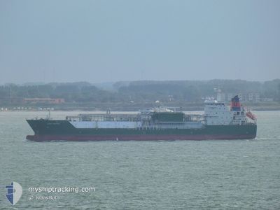
The vessel HAPPY KESTREL (IMO: 9543043, MMSI: 219221000) is a Tanker D It's sailing under the flag of [DK] Denmark.
In this page you can find informations about the vessels current position, last detected port calls, and current voyage information. If the vessels is not in coverage by AIS you will find the latest position.
The current position of HAPPY KESTREL is detected by our AIS receivers and we are not responsible for the reliability of the data. The last position was recorded while the vessel was in Coverage by the Ais receivers of our vessel tracking app.
The current draught of HAPPY KESTREL as reported by AIS is 6.5 meters
Weather
| Temperature | 16°C / 60.8°F |
|---|---|
| Wind Speed | 18 knots |
| Direction | 186° S |
| Pressure | 1009.6 hPa |
| Humidity | 72.8 % |
| Cloud Coverage | 100 % |


Featured Company
Last Port Calls
| Port | Arrival | Departure | Time In Port |
|---|---|---|---|
| 2025-02-26 16:23 | 2025-02-27 12:36 | 20 h | |
| 2025-02-24 02:12 | 2025-02-24 10:20 | 8 h | |
| 2025-02-15 06:53 | 2025-02-16 11:59 | 1 d | |
| 2025-01-28 15:01 | 2025-01-31 08:02 | 2 d | |
| 2025-01-24 07:08 | 2025-01-25 14:22 | 1 d | |
| 2024-12-12 12:10 | 2024-12-13 05:39 | 17 h | |
| 2024-12-03 22:57 | 2024-12-08 16:12 | 4 d |
Last Trips
| Origin | Departure | Destination | Arrival | Distance | |
|---|---|---|---|---|---|
| 2025-02-24 10:20 | 2025-02-26 16:23 | 10.60 nm | |||
| 2025-02-16 13:59 | 2025-02-24 02:12 | 1694.59 nm | |||
| 2025-01-31 11:02 | 2025-02-15 08:53 | 1353.47 nm | |||
| 2025-01-25 16:22 | 2025-01-28 18:01 | 705.74 nm | |||
| 2024-12-13 05:39 | 2025-01-24 09:08 | 2532.12 nm | |||
| 2024-12-08 17:12 | 2024-12-12 12:10 | 1158.77 nm | |||
| 2024-11-19 04:25 | 2024-12-03 23:57 | 517.31 nm |
Events
| Tid | Event | Detaljer | Position / Dest | Information |
|---|---|---|---|---|
| 2025-02-27 19:08 | Status ändrad | Default Under way using engine |
37.40023 / -9.38227
BANCO DEL HOYO
|
Fart: 11.9 kn Kurs: 211.6° |
| 2025-02-27 19:03 | UTANFÖR täckningsområde |
37.41381 / -9.37162
North Atlantic Ocean
BANCO DEL HOYO
|
Fart: 11.9 kn Kurs: 211.6° |
|
| 2025-02-27 16:39 | Status ändrad | Under way using engine At anchor |
37.82086 / -9.04227
BANCO DEL HOYO
|
Fart: 12.2 kn Kurs: 213.1° |
| 2025-02-27 16:38 | ETA ändrat | 2025/02/28 12:30 2025/02/28 12:00 |
37.82179 / -9.04148
BANCO DEL HOYO
|
Fart: 12.2 kn Kurs: 215.6° |
| 2025-02-27 15:44 | STARTAR förflyttning | 2.09 nm, South of SINES |
37.90930 / -8.87104
BANCO DEL HOYO
|
Fart: 3.1 kn Kurs: 224° |
| 2025-02-27 15:30 | Djupgående ändrat | 6.5 7.9 |
37.90990 / -8.86817
BANCO DEL HOYO
|
Fart: 1.3 kn Kurs: 134° |
| 2025-02-27 15:30 | Destination ändrad | BANCO DEL HOYO PTSIE |
37.90990 / -8.86817
BANCO DEL HOYO
|
Fart: 1.3 kn Kurs: 134° |
| 2025-02-27 15:30 | ETA ändrat | 2025/02/28 12:00 2025/02/22 09:00 |
37.90990 / -8.86817
BANCO DEL HOYO
|
Fart: 1.3 kn Kurs: 134° |
| 2025-02-27 13:12 | STOPPAR förflyttning | 1.98 nm, South of SINES |
37.91091 / -8.86709
PTSIE
|
Fart: 0.3 kn Kurs: 190° |
| 2025-02-27 12:54 | Status ändrad | At anchor Under way using engine |
37.90948 / -8.86700
PTSIE
|
Fart: 1.1 kn Kurs: 235° |