

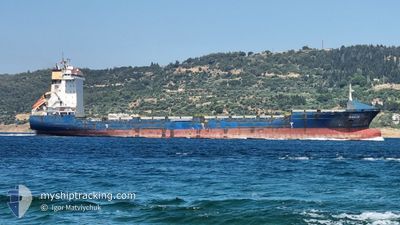
GAUJA
Container Ship

Current Trip
| Time Travelled | 3 h, 9 mins |
|---|---|
| Remaining Time | --- |
| Distance Travelled | 12.27 nm |
| Remaining Distance | --- |
| AVG Speed | 9.8 Knop |
| MAX Speed | 10.4 Knop |
| AVG Wind | 14.4 knots |
| MAX Wind | 15 knots |
| MIN Temp | 24.1°C / 75.38°F |
| MAX Temp | 24.2°C / 75.56°F |
| Djupgående | 7.7 m |
| Position mottagen | 3 m sen |
Current Position
| Longitud | --- |
|---|---|
| Latitude | --- |
| Status | At anchor |
| Fart | |
| Kurs | 322° |
| Område | Persian Gulf |
| Station | T-AIS |
| Position mottagen | 3 m sen |
Information
The current position of GAUJA is in Persian Gulf with coordinates 25.13013° / 54.87441° as reported on 2025-03-29 13:51 by AIS to our vessel tracker app. The vessel's current speed is 0 Knop
The vessel GAUJA (IMO: 9348493, MMSI: 372818000) is a Container Ship that was built in 2006 ( 19 År gammal ). It's sailing under the flag of [PA] Panama.
In this page you can find informations about the vessels current position, last detected port calls, and current voyage information. If the vessels is not in coverage by AIS you will find the latest position.
The current position of GAUJA is detected by our AIS receivers and we are not responsible for the reliability of the data. The last position was recorded while the vessel was in Coverage by the Ais receivers of our vessel tracking app.
The current draught of GAUJA as reported by AIS is 7.7 meters
Weather
| Temperature | 24°C / 75.2°F |
|---|---|
| Wind Speed | 12 knots |
| Direction | 322° NW |
| Pressure | 1011.7 hPa |
| Humidity | 67.8 % |
| Cloud Coverage | --- |


Featured Company
Last Port Calls
| Port | Arrival | Departure | Time In Port |
|---|---|---|---|
| 2025-03-28 12:13 | 2025-03-29 10:46 | 22 h | |
| 2025-03-24 02:59 | 2025-03-25 05:23 | 1 d | |
| 2025-03-18 20:07 | 2025-03-19 08:48 | 12 h | |
| 2025-03-15 16:35 | 2025-03-16 18:31 | 1 d | |
| 2025-03-08 16:00 | 2025-03-09 13:28 | 21 h | |
| 2025-02-26 07:07 | 2025-03-08 11:34 | 10 d | |
| 2025-02-24 16:59 | 2025-02-25 11:43 | 18 h | |
| 2025-02-13 08:09 | 2025-02-13 16:36 | 8 h | |
| 2025-02-11 17:59 | 2025-02-12 20:04 | 1 d | |
| 2025-02-09 00:39 | 2025-02-09 17:33 | 16 h |
Most Visited Ports (Last year)
| Port | Arrivals | |
|---|---|---|
| 12 | ||
| 10 | ||
| 9 | ||
| 7 | ||
| 5 | ||
| 5 |
Last Trips
| Origin | Departure | Destination | Arrival | Distance | |
|---|---|---|---|---|---|
| 2025-03-25 10:53 | 2025-03-28 16:13 | 967.71 nm | |||
| 2025-03-19 12:48 | 2025-03-24 08:29 | 801.52 nm | |||
| 2025-03-16 22:31 | 2025-03-19 00:07 | 604.72 nm | |||
| 2025-03-09 17:28 | 2025-03-15 20:35 | 1166.46 nm | |||
| 2025-03-08 15:34 | 2025-03-08 20:00 | 39.08 nm | |||
| 2025-02-25 15:43 | 2025-02-26 11:07 | 49.56 nm | |||
| 2025-02-12 22:04 | 2025-02-24 20:59 | 3131.30 nm | |||
| 2025-02-12 22:04 | 2025-02-13 10:09 | 52.00 nm | |||
| 2025-02-09 20:33 | 2025-02-11 19:59 | 596.81 nm | |||
| 2025-01-27 18:58 | 2025-02-09 03:39 | 3482.30 nm |
Events
| Tid | Event | Detaljer | Position / Dest | Information |
|---|---|---|---|---|
| 2025-03-29 12:09 | Status ändrad | At anchor Under way using engine |
25.13215 / 54.87432
JEBEL_ALI
|
Fart: 0.5 kn Kurs: 267° |
| 2025-03-29 12:05 | STOPPAR förflyttning | 11.16 nm, North West of JEBEL ALI |
25.13256 / 54.87440
JEBEL_ALI
|
Fart: 0.3 kn Kurs: 279° |
| 2025-03-29 10:55 | ETA ändrat | 2025/03/30 09:00 2025/03/28 15:00 |
25.05437 / 55.01153
JEBEL_ALI
|
Fart: 13.5 kn Kurs: 313.7° |
| 2025-03-29 10:48 | Djupgående ändrat | 7.7 9.2 |
25.03646 / 55.03147
JEBEL_ALI
|
Fart: 13 kn Kurs: 318.8° |
| 2025-03-29 10:47 | Status ändrad | Under way using engine Moored |
25.03370 / 55.03400
JEBEL_ALI
|
Fart: 12.5 kn Kurs: 326° |
| 2025-03-29 10:46 | AVGÅTT HAMN |
|
25.03231 / 55.03508
JEBEL_ALI
|
Fart: 12.3 kn Kurs: 325° |
| 2025-03-29 10:26 | STARTAR förflyttning |
24.99341 / 55.06048
[AE] JEBEL ALI
|
Fart: 4.2 kn Kurs: 260° |
|
| 2025-03-29 10:00 | I täckningsområde |
24.99343 / 55.06260
Persian Gulf
[AE] JEBEL ALI
|
Fart: Kurs: 55.7° |
|
| 2025-03-28 15:12 | UTANFÖR täckningsområde |
24.99348 / 55.06265
Persian Gulf
[AE] JEBEL ALI
|
Fart: Kurs: 346.4° |
|
| 2025-03-28 12:57 | Djupgående ändrat | 9.2 10 |
24.99344 / 55.06265
[AE] JEBEL ALI
|
Fart: Kurs: 227° |