
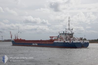
FRISIAN INO
General Cargo
Current Trip
| Time Travelled | 6 days |
|---|---|
| Remaining Time | --- |
| Distance Travelled | 1532.19 nm |
| Remaining Distance | --- |
| AVG Speed | 9.9 Knop |
| MAX Speed | 12 Knop |
| AVG Wind | 10.8 knots |
| MAX Wind | 24 knots |
| MIN Temp | 8.8°C / 47.84°F |
| MAX Temp | 17.6°C / 63.68°F |
| Djupgående | 3.1 m |
| Position mottagen | 4 d sen |
Current Position
| Longitud | --- |
|---|---|
| Latitude | --- |
| Status | Under way using engine |
| Fart | 9.6 Knop |
| Kurs | 79.4° |
| Område | Alboran Sea |
| Station | T-AIS |
| Position mottagen | 4 d sen |
Info
Information
The current position of FRISIAN INO is in Alboran Sea with coordinates 36.06797° / -4.65108° as reported on 2025-12-30 08:47 by AIS to our vessel tracker app. The vessel's current speed is 9.6 Knop and is heading at the port of AGIOS CHARALAMPOS. The estimated time of arrival as calculated by MyShipTracking vessel tracking app is 2026-01-05 22:00 LT
The vessel FRISIAN INO (IMO: 9463877, MMSI: 246807000) is a General Cargo that was built in 2012 ( 14 År gammal ). It's sailing under the flag of [NL] Netherlands.
In this page you can find informations about the vessels current position, last detected port calls, and current voyage information. If the vessels is not in coverage by AIS you will find the latest position.
The current position of FRISIAN INO is detected by our AIS receivers and we are not responsible for the reliability of the data. The last position was recorded while the vessel was in Coverage by the Ais receivers of our vessel tracking app.
The current draught of FRISIAN INO as reported by AIS is 3.1 meters
Weather
| Temperature | 17.7°C / 63.86°F |
|---|---|
| Wind Speed | 20 knots |
| Direction | 202° SSW |
| Pressure | 1016.1 hPa |
| Humidity | 70.2 % |
| Cloud Coverage | 100 % |
Featured Company
Last Port Calls
| Port | Arrival | Departure | Time In Port |
|---|---|---|---|
| 2025-12-28 07:46 | 2025-12-28 20:34 | 12 h | |
| 2025-12-21 14:15 | 2025-12-22 14:44 | 1 d | |
| 2025-12-20 19:41 | 2025-12-21 13:49 | 18 h | |
| 2025-12-18 22:22 | 2025-12-19 19:29 | 21 h | |
| 2025-12-13 07:53 | 2025-12-13 19:08 | 11 h | |
| 2025-12-11 18:11 | 2025-12-12 11:20 | 17 h | |
| 2025-12-08 10:52 | 2025-12-09 15:11 | 1 d | |
| 2025-12-04 23:13 | 2025-12-05 13:38 | 14 h | |
| 2025-11-29 15:07 | 2025-12-02 17:31 | 3 d | |
| 2025-11-23 15:54 | 2025-11-26 05:37 | 2 d |
Most Visited Ports (Last year)
| Port | Arrivals | |
|---|---|---|
| 3 | ||
| 3 | ||
| 3 | ||
| 2 | ||
| 2 | ||
| 2 |
Last Trips
| Origin | Departure | Destination | Arrival | Distance | |
|---|---|---|---|---|---|
| 2025-12-22 14:44 | 2025-12-28 07:46 | 1057.01 nm | |||
| 2025-12-21 13:49 | 2025-12-21 14:15 | 1.66 nm | |||
| 2025-12-19 19:29 | 2025-12-20 19:41 | 246.30 nm | |||
| 2025-12-13 19:08 | 2025-12-18 22:22 | 297.60 nm | |||
| 2025-12-12 11:20 | 2025-12-13 07:53 | 187.35 nm | |||
| 2025-12-09 15:11 | 2025-12-11 18:11 | 524.60 nm | |||
| 2025-12-05 13:38 | 2025-12-08 10:52 | 529.75 nm | |||
| 2025-12-02 17:31 | 2025-12-04 23:13 | 524.88 nm | |||
| 2025-11-26 05:37 | 2025-11-29 15:07 | 436.63 nm | |||
| 2025-11-20 23:15 | 2025-11-23 15:54 | 522.00 nm |
Events
| Tid | Event | Detaljer | Position / Dest | Information |
|---|---|---|---|---|
| 2025-12-30 08:52 | Status ändrad | Default Under way using engine |
36.07002 / -4.63399
GRKLM
|
Fart: 9.6 kn Kurs: 79.4° |
| 2025-12-30 08:47 | UTANFÖR täckningsområde |
36.06797 / -4.65108
Alboran Sea
GRKLM
|
Fart: 9.6 kn Kurs: 79.4° |
|
| 2025-12-30 08:27 | Status ändrad | Under way using engine Default |
36.05690 / -4.71492
GRKLM
|
Fart: 9.6 kn Kurs: 78° |
| 2025-12-30 08:25 | Status ändrad | Default Under way using engine |
36.05573 / -4.72140
GRKLM
|
Fart: 9.6 kn Kurs: 77.5° |
| 2025-12-30 07:50 | Status ändrad | Under way using engine Default |
36.03679 / -4.83441
GRKLM
|
Fart: 9 kn Kurs: 80° |
| 2025-12-30 07:09 | Status ändrad | Default Under way using engine |
36.02167 / -4.96500
GRKLM
|
Fart: 9.6 kn Kurs: 82.9° |
| 2025-12-30 05:29 | Byter havsområde | Spanish part of the Alboran Sea Spanish part of the Strait of Gibraltar |
35.98285 / -5.31734
Alboran Sea
GRKLM
|
Fart: 11.8 kn Kurs: 78.4° |
| 2025-12-30 05:13 | Byter havsområde | Spanish part of the Strait of Gibraltar Moroccan part of the Strait of Gibraltar |
35.97093 / -5.37901
Strait of Gibraltar
GRKLM
|
Fart: 11.6 kn Kurs: 75.4° |
| 2025-12-30 02:40 | Byter havsområde | Moroccan part of the Strait of Gibraltar Moroccan part of the North Atlantic Ocean |
35.91121 / -5.94975
Strait of Gibraltar
GRKLM
|
Fart: 10.9 kn Kurs: 86.1° |
| 2025-12-30 02:03 | Byter havsområde | Moroccan part of the North Atlantic Ocean Portuguese part of the North Atlantic Ocean |
35.90738 / -6.08634
North Atlantic Ocean
GRKLM
|
Fart: 10.9 kn Kurs: 90.9° |