
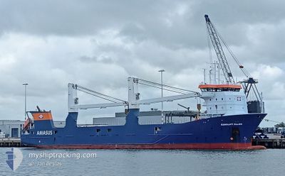
EEMSLIFT ELLEN
General Cargo
Current Trip
| Time Travelled | 2 days |
|---|---|
| Remaining Time | --- |
| Distance Travelled | 930.67 nm |
| Remaining Distance | --- |
| AVG Speed | 14.7 Knop |
| MAX Speed | 16.9 Knop |
| AVG Wind | 8.9 knots |
| MAX Wind | 21.8 knots |
| MIN Temp | 8.8°C / 47.84°F |
| MAX Temp | 14.3°C / 57.74°F |
| Djupgående | 5.5 m |
| Position mottagen | 50 m sen |
Current Position
| Longitud | -4.33849° |
|---|---|
| Latitude | 58.68539° |
| Status | Under way using engine |
| Fart | 15.9 Knop |
| Kurs | 267.8° |
| Område | North Atlantic Ocean |
| Station | T-AIS |
| Position mottagen | 50 m sen |
Info
Information
The current position of EEMSLIFT ELLEN is in North Atlantic Ocean with coordinates 58.68539° / -4.33849° as reported on 2024-05-12 04:26 by AIS to our vessel tracker app. The vessel's current speed is 15.9 Knop and is heading at the port of HEYSHAM. The estimated time of arrival as calculated by MyShipTracking vessel tracking app is 2024-05-13 02:00 LT
The vessel EEMSLIFT ELLEN (IMO: 9671474, MMSI: 244790608) is a General Cargo that was built in 2014 ( 10 År gammal ). It's sailing under the flag of [NL] Netherlands.
In this page you can find informations about the vessels current position, last detected port calls, and current voyage information. If the vessels is not in coverage by AIS you will find the latest position.
The current position of EEMSLIFT ELLEN is detected by our AIS receivers and we are not responsible for the reliability of the data. The last position was recorded while the vessel was in Coverage by the Ais receivers of our vessel tracking app.
The current draught of EEMSLIFT ELLEN as reported by AIS is 5.5 meters
Weather
| Temperature | 12.3°C / 54.14°F |
|---|---|
| Wind Speed | 5 knots |
| Direction | 188° S |
| Pressure | 1012.5 hPa |
| Humidity | 83.4 % |
| Cloud Coverage | 100 % |
Featured Company
Last Port Calls
| Port | Arrival | Departure | Time In Port |
|---|---|---|---|
| 2024-05-08 18:43 | 2024-05-09 14:55 | 20 h | |
| 2024-05-03 07:17 | 2024-05-03 19:13 | 11 h | |
| 2024-04-25 13:49 | 2024-04-26 13:22 | 23 h | |
| 2024-04-18 00:44 | 2024-04-19 01:45 | 1 d | |
| 2024-04-12 14:27 | 2024-04-13 14:47 | 1 d | |
| 2024-04-09 20:03 | 2024-04-11 12:45 | 1 d | |
| 2024-04-07 13:04 | 2024-04-07 17:05 | 4 h | |
| 2024-04-07 06:38 | 2024-04-07 11:17 | 4 h | |
| 2024-04-06 16:10 | 2024-04-06 18:21 | 2 h | |
| 2024-04-01 06:09 | 2024-04-02 12:01 | 1 d |
Most Visited Ports (Last year)
| Port | Arrivals | |
|---|---|---|
| 4 | ||
| 3 | ||
| 3 | ||
| 3 | ||
| 2 | ||
| 2 |
Last Trips
| Origin | Departure | Destination | Arrival | Distance | |
|---|---|---|---|---|---|
| 2024-05-03 21:13 | 2024-05-08 20:43 | 994.51 nm | |||
| 2024-04-26 14:22 | 2024-05-03 09:17 | 2131.70 nm | |||
| 2024-04-19 03:45 | 2024-04-25 14:49 | 1655.46 nm | |||
| 2024-04-13 16:47 | 2024-04-18 02:44 | 915.79 nm | |||
| 2024-04-11 14:45 | 2024-04-12 16:27 | 229.36 nm | |||
| 2024-04-07 19:05 | 2024-04-09 22:03 | 626.14 nm | |||
| 2024-04-07 13:17 | 2024-04-07 15:04 | 4.81 nm | |||
| 2024-04-06 20:21 | 2024-04-07 08:38 | 162.61 nm | |||
| 2024-04-02 15:01 | 2024-04-06 18:10 | 964.42 nm | |||
| 2024-03-28 16:01 | 2024-04-01 09:09 | 927.45 nm |
Events
| Tid | Event | Detaljer | Position / Dest | Information |
|---|---|---|---|---|
| 2024-05-12 04:46 | Status ändrad | Default Under way using engine |
58.68167 / -4.51500
GBHYM
|
Fart: 15.9 kn Kurs: 267.8° |
| 2024-05-12 02:38 | Byter havsområde | United Kingdom part of the North Atlantic Ocean United Kingdom part of the North Sea |
58.70472 / -3.42869
North Atlantic Ocean
GBHYM
|
Fart: 16 kn Kurs: 267.4° |
| 2024-05-12 00:25 | Status ändrad | Under way using engine Default |
58.69904 / -2.36898
GBHYM
|
Fart: 14.4 kn Kurs: 272° |
| 2024-05-12 00:22 | Status ändrad | Default Under way using engine |
58.69866 / -2.34750
GBHYM
|
Fart: 14.4 kn Kurs: 272.6° |
| 2024-05-12 00:22 | Status ändrad | Under way using engine Default |
58.69861 / -2.34429
GBHYM
|
Fart: 14.5 kn Kurs: 274° |
| 2024-05-12 00:22 | Byter havsområde | United Kingdom part of the North Sea Norwegian part of the North Sea |
58.69861 / -2.34429
North Sea
GBHYM
|
Fart: 14.4 kn Kurs: 272.6° |
| 2024-05-12 00:03 | I täckningsområde |
58.69861 / -2.34429
North Sea
GBHYM
|
Fart: 14.4 kn Kurs: 272.6° |
|
| 2024-05-11 13:34 | Status ändrad | Default Under way using engine |
58.22833 / 2.71667
GBHYM
|
Fart: 14.9 kn Kurs: 280.7° |
| 2024-05-11 13:01 | Status ändrad | Under way using engine Default |
58.20363 / 2.97330
GBHYM
|
Fart: 14.9 kn Kurs: 282° |
| 2024-05-11 13:01 | UTANFÖR täckningsområde |
58.20363 / 2.97330
North Sea
GBHYM
|
Fart: 14.9 kn Kurs: 280.7° |