
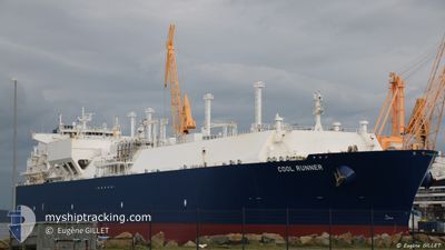
COOL RUNNER
Lng Tanker
Current Trip
| Time Travelled | 14 days |
|---|---|
| Remaining Time | 6 days |
| Distance Travelled | 3378.60 nm |
| Remaining Distance | 1646.92 nm |
| AVG Speed | 10.2 Knop |
| MAX Speed | 14.8 Knop |
| AVG Wind | 13.9 knots |
| MAX Wind | 34.2 knots |
| MIN Temp | 3.5°C / 38.3°F |
| MAX Temp | 18.3°C / 64.94°F |
| Djupgående | 10.6 m |
| Position mottagen | 6 d sen |
Current Position
| Longitud | --- |
|---|---|
| Latitude | --- |
| Status | Under way using engine |
| Fart | 10.1 Knop |
| Kurs | 245.2° |
| Område | English Channel |
| Station | T-AIS |
| Position mottagen | 6 d sen |
Info
Information
The current position of COOL RUNNER is in English Channel with coordinates 49.53518° / -4.07434° as reported on 2025-03-11 05:52 by AIS to our vessel tracker app. The vessel's current speed is 10.1 Knop and is heading at the port of TERNEUZEN. The estimated time of arrival as calculated by MyShipTracking vessel tracking app is 2025-03-24 15:12 LT
The vessel COOL RUNNER (IMO: 9636797, MMSI: 229673000) is a Lng Tanker that was built in 2014 ( 11 År gammal ). It's sailing under the flag of [MT] Malta.
In this page you can find informations about the vessels current position, last detected port calls, and current voyage information. If the vessels is not in coverage by AIS you will find the latest position.
The current position of COOL RUNNER is detected by our AIS receivers and we are not responsible for the reliability of the data. The last position was recorded while the vessel was in Coverage by the Ais receivers of our vessel tracking app.
The current draught of COOL RUNNER as reported by AIS is 10.6 meters
Weather
| Temperature | 18.3°C / 64.94°F |
|---|---|
| Wind Speed | 16 knots |
| Direction | 316° NW |
| Pressure | 1022.2 hPa |
| Humidity | 68.9 % |
| Cloud Coverage | 2 % |
Featured Company
Last Trips
Events
| Tid | Event | Detaljer | Position / Dest | Information |
|---|---|---|---|---|
| 2025-03-11 06:00 | Status ändrad | Default Under way using engine |
49.52631 / -4.10306
FOR ORDERS
|
Fart: 10.1 kn Kurs: 245.2° |
| 2025-03-11 05:52 | Status ändrad | Under way using engine Default |
49.53518 / -4.07434
FOR ORDERS
|
Fart: 10.2 kn Kurs: 245° |
| 2025-03-11 05:52 | UTANFÖR täckningsområde |
49.53518 / -4.07434
English Channel
|
Fart: 10.1 kn Kurs: 245.2° |
|
| 2025-03-11 05:28 | Status ändrad | Default Under way using engine |
49.56459 / -3.97912
FOR ORDERS
|
Fart: 9.8 kn Kurs: 244.1° |
| 2025-03-11 04:45 | Status ändrad | Under way using engine Default |
49.61684 / -3.82199
FOR ORDERS
|
Fart: 9.5 kn Kurs: 236° |
| 2025-03-11 04:36 | Status ändrad | Default Under way using engine |
49.63206 / -3.79038
FOR ORDERS
|
Fart: 9.4 kn Kurs: 233.3° |
| 2025-03-11 01:59 | Upptäckt i hav | United Kingdom part of the English Channel |
49.85617 / -3.23693
English Channel
|
Fart: 10.5 kn Kurs: 245.5° |
| 2025-03-11 01:59 | Status ändrad | Under way using engine Default |
49.85637 / -3.23624
FOR ORDERS
|
Fart: 10.5 kn Kurs: 246° |
| 2025-03-11 01:52 | I täckningsområde |
49.85617 / -3.23693
English Channel
|
Fart: 10.5 kn Kurs: 245.5° |
|
| 2025-03-11 00:35 | UTANFÖR täckningsområde |
49.96300 / -2.87069
English Channel
|
Fart: 11.8 kn Kurs: 246.3° |