
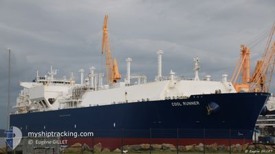
COOL RUNNER
Lng Tanker
Current Trip
| Trip Time | 11 days |
|---|---|
| Trip Distance | 2742.21 nm |
| AVG Speed | 8.6 Noeuds |
| MAX Speed | 15.2 Noeuds |
| Tirant d eau | 11.4 m |
| AVG Wind | 20.6 knots |
| MAX Wind | 41 knots |
| MIN Temp | -0.8°C / 30.56°F |
| MAX Temp | 16.3°C / 61.34°F |
| Position reçue | 1 d depuis |
Current Position
| Longitude | --- |
|---|---|
| Latitude | --- |
| Etat | Under way using engine |
| Vitesse | 11.5 Noeuds |
| Parcours | 9° |
| Zone | Celtic Sea |
| Station | T-AIS |
| Position reçue | 1 d depuis |
Info
Information
The current position of COOL RUNNER is in Celtic Sea with coordinates 51.53617° / -5.26650° as reported on 2024-12-01 08:25 by AIS to our vessel tracker app. The vessel's current speed is 11.5 Noeuds and is currently inside the port of PEMBROKE.
The vessel COOL RUNNER (IMO: 9636797, MMSI: 229673000) is a Lng Tanker that was built in 2014 ( 10 Age ). It's sailing under the flag of [MT] Malta.
In this page you can find informations about the vessels current position, last detected port calls, and current voyage information. If the vessels is not in coverage by AIS you will find the latest position.
The current position of COOL RUNNER is detected by our AIS receivers and we are not responsible for the reliability of the data. The last position was recorded while the vessel was in Coverage by the Ais receivers of our vessel tracking app.
The current draught of COOL RUNNER as reported by AIS is 11.4 meters
Weather
| Temperature | 8.2°C / 46.76°F |
|---|---|
| Wind Speed | 18 knots |
| Direction | 321° NW |
| Pressure | 1016.3 hPa |
| Humidity | 70.2 % |
| Cloud Coverage | 100 % |
Featured Company
Last Port Calls
| Port | Arrival | Departure | Time In Port |
|---|---|---|---|
| 2024-12-01 09:58 | |||
| 2024-11-18 19:35 | 2024-11-20 04:28 | 1 d | |
| 2024-11-11 22:27 | 2024-11-13 14:28 | 1 d | |
| 2024-10-13 13:43 | 2024-10-14 22:19 | 1 d |
Last Trips
| Origin | Departure | Destination | Arrival | Distance | |
|---|---|---|---|---|---|
| 2024-11-20 05:28 | 2024-12-01 09:58 | 2742.21 nm | |||
| 2024-11-13 16:28 | 2024-11-18 20:35 | 1825.58 nm | |||
| 2024-10-14 17:19 | 2024-11-12 00:27 | 6494.54 nm | |||
| 2024-09-05 11:06 | 2024-10-13 08:43 | 15791.10 nm |
Events
| Heure | Evenement | Détails | Position/ Destination | Info |
|---|---|---|---|---|
| 2024-12-01 10:48 | Arret |
51.69980 / -5.00168
[GB] PEMBROKE
|
Vitesse: Parcours: 98° |
|
| 2024-12-01 09:58 | Port d'arrivée |
|
51.69747 / -5.06704
[GB] PEMBROKE
|
Vitesse: 7.3 kn Parcours: 79° |
| 2024-12-01 08:30 | Etat Changé | Default Under way using engine |
51.55544 / -5.26059
GB MLF
|
Vitesse: 11.5 kn Parcours: 9° |
| 2024-12-01 08:25 | Etat Changé | Under way using engine Default |
51.53617 / -5.26650
GB MLF
|
Vitesse: 10.9 kn Parcours: 10° |
| 2024-12-01 08:25 | Hors de la zone couverte |
51.53617 / -5.26650
Celtic Sea
|
Vitesse: 11.5 kn Parcours: 9° |
|
| 2024-12-01 07:54 | Etat Changé | Default Under way using engine |
51.49141 / -5.22636
GB MLF
|
Vitesse: 7.8 kn Parcours: 269.8° |
| 2024-12-01 07:54 | Etat Changé | Under way using engine Default |
51.49141 / -5.22397
GB MLF
|
Vitesse: 8 kn Parcours: 270° |
| 2024-12-01 07:50 | Etat Changé | Default Under way using engine |
51.49137 / -5.21226
GB MLF
|
Vitesse: 7.8 kn Parcours: 267.2° |
| 2024-12-01 07:44 | Etat Changé | Under way using engine Default |
51.49191 / -5.18827
GB MLF
|
Vitesse: 7.3 kn Parcours: 259° |
| 2024-12-01 07:42 | Etat Changé | Default Under way using engine |
51.49223 / -5.18443
GB MLF
|
Vitesse: 5.9 kn Parcours: 178° |