
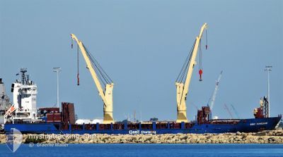
BBC XINGANG
General Cargo
Current Trip
| Trip Time | 1 day |
|---|---|
| Trip Distance | 319.44 nm |
| AVG Speed | 11.9 Knop |
| MAX Speed | 14.2 Knop |
| Djupgående | 6.6 m |
| AVG Wind | 8.5 knots |
| MAX Wind | 16 knots |
| MIN Temp | 19.1°C / 66.38°F |
| MAX Temp | 23.7°C / 74.66°F |
| Position mottagen | 4 h, 33 m sen |
Current Position
| Longitud | 5.01551° |
|---|---|
| Latitude | 43.40308° |
| Status | Moored |
| Fart | |
| Kurs | 272° |
| Område | Mediterranean Sea - Western Basin |
| Station | T-AIS |
| Position mottagen | 4 h, 33 m sen |
Info
Information
The current position of BBC XINGANG is in Mediterranean Sea - Western Basin with coordinates 43.40308° / 5.01551° as reported on 2024-06-06 02:59 by AIS to our vessel tracker app. The vessel's current speed is 0 Knop and is currently inside the port of CARONTE.
The vessel BBC XINGANG (IMO: 9508483, MMSI: 305885000) is a General Cargo that was built in 2013 ( 11 År gammal ). It's sailing under the flag of [AG] Antigua Barbuda.
In this page you can find informations about the vessels current position, last detected port calls, and current voyage information. If the vessels is not in coverage by AIS you will find the latest position.
The current position of BBC XINGANG is detected by our AIS receivers and we are not responsible for the reliability of the data. The last position was recorded while the vessel was in Coverage by the Ais receivers of our vessel tracking app.
The current draught of BBC XINGANG as reported by AIS is 6.6 meters
Weather
| Temperature | 21.3°C / 70.34°F |
|---|---|
| Wind Speed | 6 knots |
| Direction | 132° SE |
| Pressure | 1017.7 hPa |
| Humidity | 62.5 % |
| Cloud Coverage | 100 % |
Featured Company
Most Visited Ports (Last year)
| Port | Arrivals | |
|---|---|---|
| 3 | ||
| 2 | ||
| 2 | ||
| 2 | ||
| 1 | ||
| 1 |
Events
| Tid | Event | Detaljer | Position / Dest | Information |
|---|---|---|---|---|
| 2024-06-06 02:59 | UTANFÖR täckningsområde |
43.40308 / 5.01551
Mediterranean Sea - Western Basin
[FR] CARONTE
|
Fart: Kurs: 6° |
|
| 2024-06-06 02:08 | I täckningsområde |
43.40302 / 5.01555
Mediterranean Sea - Western Basin
[FR] CARONTE
|
Fart: Kurs: 6° |
|
| 2024-06-06 00:50 | UTANFÖR täckningsområde |
43.40307 / 5.01551
Mediterranean Sea - Western Basin
[FR] CARONTE
|
Fart: Kurs: 6° |
|
| 2024-06-05 18:23 | Status ändrad | Moored Under way using engine |
43.40310 / 5.01553
[FR] CARONTE
|
Fart: Kurs: 271° |
| 2024-06-05 18:15 | STOPPAR förflyttning |
43.40299 / 5.01546
[FR] CARONTE
|
Fart: 0.1 kn Kurs: 273° |
|
| 2024-06-05 17:46 | ANLÄNDER HAMN |
|
43.40285 / 5.01177
[FR] CARONTE
|
Fart: 4.1 kn Kurs: 93° |
| 2024-06-05 15:06 | Djupgående ändrat | 6.6 6.9 |
43.13838 / 4.98551
FRCOZ
|
Fart: 8.2 kn Kurs: 35.9° |
| 2024-06-05 15:04 | Status ändrad | Under way using engine Default |
43.13500 / 4.98227
FRCOZ
|
Fart: 8 kn Kurs: 35° |
| 2024-06-05 14:54 | Status ändrad | Default Under way using engine |
43.11684 / 4.96513
FRCOZ
|
Fart: 7.9 kn Kurs: 35° |
| 2024-06-05 13:54 | Status ändrad | Under way using engine Default |
42.95649 / 4.80075
FRCOZ
|
Fart: 13 kn Kurs: 39° |