
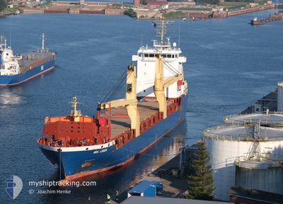
BBC LISBON
General Cargo
Current Trip
| Time Travelled | 2 days |
|---|---|
| Remaining Time | --- |
| Distance Travelled | 500.70 nm |
| Remaining Distance | --- |
| AVG Speed | 10.2 Knop |
| MAX Speed | 11.5 Knop |
| AVG Wind | 16.1 knots |
| MAX Wind | 20.9 knots |
| MIN Temp | 16.9°C / 62.42°F |
| MAX Temp | 19.4°C / 66.92°F |
| Djupgående | 7.1 m |
| Position mottagen | 22 d sen |
Current Position
| Longitud | --- |
|---|---|
| Latitude | --- |
| Status | Under way using engine |
| Fart | 9.4 Knop |
| Kurs | 327.9° |
| Område | South Atlantic Ocean |
| Station | T-AIS |
| Position mottagen | 22 d sen |
Info
Information
The current position of BBC LISBON is in South Atlantic Ocean with coordinates -22.63346° / 13.95983° as reported on 2025-01-25 15:43 by AIS to our vessel tracker app. The vessel's current speed is 9.4 Knop and is heading at the port of WALVIS BAY.
The vessel BBC LISBON (IMO: 9513634, MMSI: 305688000) is a General Cargo that was built in 2011 ( 14 År gammal ). It's sailing under the flag of [AG] Antigua Barbuda.
In this page you can find informations about the vessels current position, last detected port calls, and current voyage information. If the vessels is not in coverage by AIS you will find the latest position.
The current position of BBC LISBON is detected by our AIS receivers and we are not responsible for the reliability of the data. The last position was recorded while the vessel was in Coverage by the Ais receivers of our vessel tracking app.
The current draught of BBC LISBON as reported by AIS is 7.1 meters
Weather
| Temperature | 17°C / 62.6°F |
|---|---|
| Wind Speed | 17 knots |
| Direction | 22° NNE |
| Pressure | 1017.2 hPa |
| Humidity | 81.7 % |
| Cloud Coverage | --- |
Featured Company
Last Port Calls
| Port | Arrival | Departure | Time In Port |
|---|---|---|---|
| 2025-02-12 21:19 | 2025-02-14 23:47 | 2 d | |
| 2025-01-31 07:36 | 2025-02-04 02:12 | 3 d | |
| 2025-01-01 04:00 | 2025-01-03 16:57 | 2 d | |
| 2024-12-22 07:23 | 2024-12-25 10:48 | 3 d |
Last Trips
| Origin | Departure | Destination | Arrival | Distance | |
|---|---|---|---|---|---|
| 2025-02-04 02:12 | 2025-02-12 21:19 | 2253.21 nm | |||
| 2025-01-03 16:57 | 2025-01-31 07:36 | 6609.09 nm | |||
| 2024-12-25 10:48 | 2025-01-01 04:00 | 19.52 nm | |||
| 2024-11-29 21:31 | 2024-12-22 07:23 | 4362.33 nm |
Events
| Tid | Event | Detaljer | Position / Dest | Information |
|---|---|---|---|---|
| 2025-02-14 23:47 | AVGÅTT HAMN |
|
14.67737 / -17.41384
WALVIS BAY
|
Fart: 5 kn Kurs: 90° |
| 2025-02-14 23:35 | STARTAR förflyttning |
14.68406 / -17.42790
[SN] DAKAR
|
Fart: 5.5 kn Kurs: 164° |
|
| 2025-02-12 21:35 | STOPPAR förflyttning |
14.69075 / -17.43023
[SN] DAKAR
|
Fart: Kurs: 18° |
|
| 2025-02-12 21:19 | ANLÄNDER HAMN |
|
14.68363 / -17.42720
[SN] DAKAR
|
Fart: 7.7 kn Kurs: 268° |
| 2025-02-12 20:18 | STARTAR förflyttning | 5.84 nm, South East of GOREE |
14.60212 / -17.32553
WALVIS BAY
|
Fart: 7.3 kn Kurs: 340° |
| 2025-02-12 16:43 | STOPPAR förflyttning | 6.33 nm, South East of GOREE |
14.59503 / -17.32079
WALVIS BAY
|
Fart: 0.3 kn Kurs: 321° |