
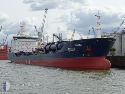
BASAT
Oil/Chemical Tanker
Current Trip
| Time Travelled | 20 h, 43 mins |
|---|---|
| Remaining Time | 1 day |
| Distance Travelled | 256.21 nm |
| Remaining Distance | 371.37 nm |
| AVG Speed | 12.3 Knop |
| MAX Speed | 13.5 Knop |
| AVG Wind | 12.2 knots |
| MAX Wind | 17 knots |
| MIN Temp | -4.7°C / 23.54°F |
| MAX Temp | 3°C / 37.4°F |
| Djupgående | 7.2 m |
| Position mottagen | 1 m sen |
Current Position
| Longitud | --- |
|---|---|
| Latitude | --- |
| Status | Under way using engine |
| Fart | 12.7 Knop |
| Kurs | 217° |
| Område | North Sea |
| Station | T-AIS |
| Position mottagen | 1 m sen |
Info
Information
The current position of BASAT is in North Sea with coordinates 57.21617° / 7.96750° as reported on 2025-02-17 22:06 by AIS to our vessel tracker app. The vessel's current speed is 12.7 Knop and is heading at the port of ROTTERDAM. The estimated time of arrival as calculated by MyShipTracking vessel tracking app is 2025-02-19 03:08 LT
The vessel BASAT (IMO: 9447029, MMSI: 249255000) is a Oil/Chemical Tanker that was built in 2008 ( 17 År gammal ). It's sailing under the flag of [MT] Malta.
In this page you can find informations about the vessels current position, last detected port calls, and current voyage information. If the vessels is not in coverage by AIS you will find the latest position.
The current position of BASAT is detected by our AIS receivers and we are not responsible for the reliability of the data. The last position was recorded while the vessel was in Coverage by the Ais receivers of our vessel tracking app.
The current draught of BASAT as reported by AIS is 7.2 meters
Weather
| Temperature | 2.7°C / 36.86°F |
|---|---|
| Wind Speed | 4 knots |
| Direction | 238° WSW |
| Pressure | 1026.1 hPa |
| Humidity | 54.7 % |
| Cloud Coverage | --- |
Featured Company
Last Port Calls
| Port | Arrival | Departure | Time In Port |
|---|---|---|---|
| 2025-02-16 03:19 | 2025-02-17 01:24 | 22 h | |
| 2025-02-09 15:08 | 2025-02-10 18:09 | 1 d | |
| 2025-02-05 07:40 | 2025-02-06 10:18 | 1 d | |
| 2025-01-31 15:33 | 2025-02-02 10:41 | 1 d | |
| 2025-01-31 09:18 | 2025-01-31 15:01 | 5 h | |
| 2025-01-29 06:21 | 2025-01-31 07:32 | 2 d | |
| 2025-01-23 23:31 | 2025-01-25 04:21 | 1 d | |
| 2025-01-19 19:49 | 2025-01-21 03:29 | 1 d | |
| 2024-12-26 15:31 | 2024-12-28 15:23 | 1 d | |
| 2024-12-05 22:05 | 2024-12-08 16:12 | 2 d |
Last Trips
| Origin | Departure | Destination | Arrival | Distance | |
|---|---|---|---|---|---|
| 2025-02-10 20:09 | 2025-02-16 04:19 | 704.98 nm | |||
| 2025-02-06 11:18 | 2025-02-09 17:08 | 456.07 nm | |||
| 2025-02-02 11:41 | 2025-02-05 08:40 | 762.63 nm | |||
| 2025-01-31 16:01 | 2025-01-31 16:33 | 2.20 nm | |||
| 2025-01-31 08:32 | 2025-01-31 10:18 | 12.61 nm | |||
| 2025-01-25 06:21 | 2025-01-29 07:21 | 1076.92 nm | |||
| 2025-01-21 05:29 | 2025-01-24 01:31 | 95.10 nm | |||
| 2024-12-28 09:23 | 2025-01-19 21:49 | 6444.25 nm | |||
| 2024-12-08 17:12 | 2024-12-26 09:31 | 5770.68 nm | |||
| 2024-12-02 17:20 | 2024-12-05 23:05 | 18.66 nm |
Events
| Tid | Event | Detaljer | Position / Dest | Information |
|---|---|---|---|---|
| 2025-02-17 21:13 | Byter havsområde | Danish part of the North Sea Danish part of the Skaggerak |
57.34531 / 8.19719
North Sea
NLRTM
|
Fart: 12.3 kn Kurs: 238.1° |
| 2025-02-17 13:31 | Byter havsområde | Danish part of the Skaggerak Danish part of the Kattegat |
57.80833 / 10.94100
Skaggerak
NLRTM
|
Fart: 13.3 kn Kurs: 317° |
| 2025-02-17 12:25 | Upptäckt i hav | Danish part of the Kattegat |
57.62950 / 11.22750
Kattegat
NLRTM
|
Fart: 12.5 kn Kurs: 317.9° |
| 2025-02-17 09:01 | Byter havsområde | Swedish part of the Kattegat Danish part of the Kattegat |
57.01564 / 11.74516
Kattegat
NLRTM
|
Fart: 12 kn Kurs: 341.9° |
| 2025-02-17 01:34 | ETA ändrat | 2025/02/19 02:00 2025/02/19 10:00 |
56.14876 / 10.28877
NLRTM
|
Fart: 10.8 kn Kurs: 115.4° |
| 2025-02-17 01:24 | AVGÅTT HAMN |
|
56.15850 / 10.25200
NLRTM
|
Fart: 5.1 kn Kurs: 116° |
| 2025-02-17 01:10 | STARTAR förflyttning |
56.14883 / 10.22667
[DK] AARHUS
|
Fart: 3.3 kn Kurs: 55° |
|
| 2025-02-17 01:06 | Status ändrad | Under way using engine Moored |
56.14783 / 10.22417
[DK] AARHUS
|
Fart: 0.1 kn Kurs: 42° |
| 2025-02-16 23:11 | Status ändrad | Moored Default |
56.14800 / 10.22417
[DK] AARHUS
|
Fart: Kurs: 35° |
| 2025-02-16 23:08 | Status ändrad | Default Moored |
56.14800 / 10.22417
[DK] AARHUS
|
Fart: Kurs: 35° |