
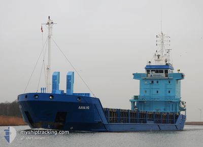
AAVA VG
General Cargo
Current Trip
| Time Travelled | 19 h, 49 mins |
|---|---|
| Remaining Time | -14 mins |
| Distance Travelled | 165.43 nm |
| Remaining Distance | 1.72 nm |
| AVG Speed | 8.7 Knop |
| MAX Speed | 10 Knop |
| AVG Wind | 14.7 knots |
| MAX Wind | 24.5 knots |
| MIN Temp | 2°C / 35.6°F |
| MAX Temp | 5.1°C / 41.18°F |
| Djupgående | 3.7 m |
| Position mottagen | 1 m sen |
Current Position
| Longitud | --- |
|---|---|
| Latitude | --- |
| Status | Under way using engine |
| Fart | 0.1 Knop |
| Kurs | 54° |
| Område | Gulf of Bothnia |
| Station | T-AIS |
| Position mottagen | 1 m sen |
Info
Information
The current position of AAVA VG is in Gulf of Bothnia with coordinates 60.79451° / 21.33957° as reported on 2024-12-22 09:28 by AIS to our vessel tracker app. The vessel's current speed is 0.1 Knop and is heading at the port of UUSIKAUPUNKI. The estimated time of arrival as calculated by MyShipTracking vessel tracking app is 2024-12-22 09:16 LT
The vessel AAVA VG (IMO: 9179361, MMSI: 212308000) is a General Cargo that was built in 1998 ( 26 År gammal ). It's sailing under the flag of [CY] Cyprus.
In this page you can find informations about the vessels current position, last detected port calls, and current voyage information. If the vessels is not in coverage by AIS you will find the latest position.
The current position of AAVA VG is detected by our AIS receivers and we are not responsible for the reliability of the data. The last position was recorded while the vessel was in Coverage by the Ais receivers of our vessel tracking app.
The current draught of AAVA VG as reported by AIS is 3.7 meters
Weather
| Temperature | 3.3°C / 37.94°F |
|---|---|
| Wind Speed | 12 knots |
| Direction | 214° SW |
| Pressure | 983.5 hPa |
| Humidity | 97.1 % |
| Cloud Coverage | 100 % |
Featured Company
Last Port Calls
| Port | Arrival | Departure | Time In Port |
|---|---|---|---|
| 2024-12-20 05:10 | 2024-12-21 13:41 | 1 d | |
| 2024-12-19 07:09 | 2024-12-19 23:59 | 16 h | |
| 2024-12-11 15:44 | 2024-12-12 12:55 | 21 h | |
| 2024-12-04 20:45 | 2024-12-07 09:14 | 2 d | |
| 2024-11-20 02:28 | 2024-11-23 07:44 | 3 d | |
| 2024-11-17 09:11 | 2024-11-19 16:01 | 2 d | |
| 2024-11-09 10:54 | 2024-11-11 18:16 | 2 d | |
| 2024-11-08 04:24 | 2024-11-08 18:12 | 13 h | |
| 2024-11-07 03:44 | 2024-11-07 16:32 | 12 h | |
| 2024-11-04 06:02 | 2024-11-05 17:09 | 1 d |
Most Visited Ports (Last year)
| Port | Arrivals | |
|---|---|---|
| 6 | ||
| 6 | ||
| 6 | ||
| 3 | ||
| 3 | ||
| 3 |
Last Trips
| Origin | Departure | Destination | Arrival | Distance | |
|---|---|---|---|---|---|
| 2024-12-20 01:59 | 2024-12-20 07:10 | 49.82 nm | |||
| 2024-12-12 12:55 | 2024-12-19 09:09 | 1369.11 nm | |||
| 2024-12-07 09:14 | 2024-12-11 15:44 | 469.61 nm | |||
| 2024-11-23 08:44 | 2024-12-04 20:45 | 2215.88 nm | |||
| 2024-11-19 17:01 | 2024-11-20 03:28 | 113.87 nm | |||
| 2024-11-11 20:16 | 2024-11-17 10:11 | 1110.13 nm | |||
| 2024-11-08 19:12 | 2024-11-09 12:54 | 135.66 nm | |||
| 2024-11-07 18:32 | 2024-11-08 05:24 | 105.18 nm | |||
| 2024-11-05 19:09 | 2024-11-07 05:44 | 346.01 nm | |||
| 2024-11-01 06:08 | 2024-11-04 08:02 | 718.21 nm |
Events
| Tid | Event | Detaljer | Position / Dest | Information |
|---|---|---|---|---|
| 2024-12-22 09:27 | Status ändrad | Under way using engine Default |
60.79449 / 21.33953
FIUKI
|
Fart: 0.4 kn Kurs: 70° |
| 2024-12-22 09:27 | STOPPAR förflyttning | 1.39 nm, West of UUSIKAUPUNKI |
60.79449 / 21.33953
FIUKI
|
Fart: Kurs: 56° |
| 2024-12-22 09:12 | Status ändrad | Default Under way using engine |
60.79339 / 21.33477
FIUKI
|
Fart: 2.4 kn Kurs: 44° |
| 2024-12-22 09:03 | Status ändrad | Under way using engine Default |
60.78842 / 21.32519
FIUKI
|
Fart: 5.7 kn Kurs: 66° |
| 2024-12-22 08:45 | Status ändrad | Default Under way using engine |
60.79266 / 21.26074
FIUKI
|
Fart: 8.4 kn Kurs: 73.6° |
| 2024-12-22 08:34 | Status ändrad | Under way using engine Default |
60.78249 / 21.21348
FIUKI
|
Fart: 8.4 kn Kurs: 35° |
| 2024-12-22 08:33 | Status ändrad | Default Under way using engine |
60.78013 / 21.20925
FIUKI
|
Fart: 8.4 kn Kurs: 27.4° |
| 2024-12-22 08:32 | Status ändrad | Under way using engine Default |
60.77950 / 21.20838
FIUKI
|
Fart: 8.9 kn Kurs: 2° |
| 2024-12-22 08:29 | Status ändrad | Default Under way using engine |
60.77100 / 21.20676
FIUKI
|
Fart: 8.7 kn Kurs: 47.7° |
| 2024-12-22 08:16 | Status ändrad | Under way using engine Default |
60.74503 / 21.17667
FIUKI
|
Fart: 8.8 kn Kurs: 30° |