
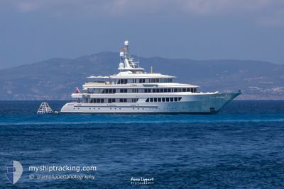
UTOPIA
Yacht
Current Trip
MARIGMNG
| Time Travelled | 15 days |
|---|---|
| Remaining Time | --- |
| Distance Travelled | 3178.27 морская миля |
| Remaining Distance | --- |
| AVG Speed | 12 Узлы |
| MAX Speed | 13.9 Узлы |
| AVG Wind | 13.5 knots |
| MAX Wind | 20 knots |
| MIN Temp | 11.1°C / 51.98°F |
| MAX Temp | 25.6°C / 78.08°F |
| Осадка | 3.6 м |
| Позиция Получена | 2 m тому назад |
Current Position
| Долгота | --- |
|---|---|
| Широта | --- |
| Статус | Under way using engine |
| Скорость | 13.5 Узлы |
| Курс | 98° |
| Район | North Atlantic Ocean |
| Станция | T-AIS |
| Позиция Получена | 2 m тому назад |
Info
Information
The current position of UTOPIA is in North Atlantic Ocean with coordinates 36.11617° / -8.46600° as reported on 2026-04-02 19:52 by AIS to our vessel tracker app. The vessel's current speed is 13.5 Узлы
The vessel UTOPIA (IMO: 1007263, MMSI: 319326000) is a Yacht that was built in 2004 ( 22 лет ). It's sailing under the flag of [KY] Cayman Is.
In this page you can find informations about the vessels current position, last detected port calls, and current voyage information. If the vessels is not in coverage by AIS you will find the latest position.
The current position of UTOPIA is detected by our AIS receivers and we are not responsible for the reliability of the data. The last position was recorded while the vessel was in Coverage by the Ais receivers of our vessel tracking app.
The current draught of UTOPIA as reported by AIS is 3.6 meters
Weather
| Temperature | 15.8°C / 60.44°F |
|---|---|
| Wind Speed | 14 knots |
| Direction | 333° NNW |
| Pressure | 1019.7 hPa |
| Humidity | 82.5 % |
| Cloud Coverage | --- |
Featured Company
Last Port Calls
| Port | Arrival | Departure | Time In Port |
|---|---|---|---|
| 2026-03-17 09:23 | 2026-03-18 08:01 | 22 h | |
| 2026-02-20 16:14 |
Most Visited Ports (Last year)
| Port | Arrivals | |
|---|---|---|
| 7 | ||
| 3 | ||
| 3 | ||
| 2 | ||
| 1 | ||
| 1 |
Last Trips
| Origin | Departure | Destination | Arrival | Distance | |
|---|---|---|---|---|---|
| 2026-02-20 16:14 | 2026-03-17 09:23 | 278.73 морская миля |
Events
| Время | Событие | Детали | Позиция / Направление | Информация |
|---|---|---|---|---|
| 2026-04-02 09:02 | В покрытии |
36.38850 / -11.44533
North Atlantic Ocean
|
Скорость: 13.2 kn Курс: 100° |
|
| 2026-04-02 07:08 | Вне покрытия |
36.43900 / -11.96208
North Atlantic Ocean
|
Скорость: 13.2 kn Курс: 97° |
|
| 2026-04-02 05:17 | Обнаружено в море | Portuguese part of the North Atlantic Ocean |
36.48350 / -12.45700
North Atlantic Ocean
|
Скорость: 13.2 kn Курс: 96° |
| 2026-04-02 05:17 | В покрытии |
36.48350 / -12.45700
North Atlantic Ocean
|
Скорость: 13.2 kn Курс: 96° |
|
| 2026-04-02 02:03 | Вне покрытия |
36.56403 / -13.34869
North Atlantic Ocean
|
Скорость: 13.3 kn Курс: 95° |
|
| 2026-04-02 00:04 | В покрытии |
36.61716 / -13.89628
North Atlantic Ocean
|
Скорость: 13.3 kn Курс: 96° |
|
| 2026-04-01 21:44 | Вне покрытия |
36.67582 / -14.53211
North Atlantic Ocean
|
Скорость: 13.1 kn Курс: 98° |
|
| 2026-04-01 13:04 | Изменение морского района | High seas of the North Atlantic Ocean Portuguese (Azores) part of the North Atlantic Ocean |
36.88301 / -16.87320
North Atlantic Ocean
|
Скорость: 13.3 kn Курс: 98° |
| 2026-04-01 13:02 | В покрытии |
36.88301 / -16.87320
North Atlantic Ocean
|
Скорость: 13.3 kn Курс: 98° |
|
| 2026-03-31 06:12 | Вне покрытия |
37.59469 / -24.60680
North Atlantic Ocean
|
Скорость: 11.7 kn Курс: 97° |