

TOSTE R
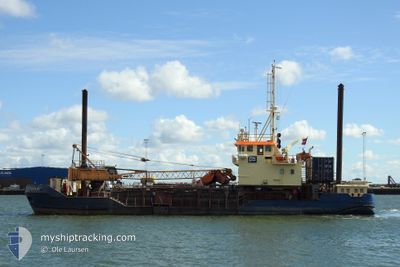
Trailing Suction Hopper Dredger

Current Trip
UDERWATER DREDGING
| Time Travelled | 1 day |
|---|---|
| Remaining Time | --- |
| Distance Travelled | 154.87 морская миля |
| Remaining Distance | --- |
| AVG Speed | 7 Узлы |
| MAX Speed | 7.7 Узлы |
| AVG Wind | 7.8 knots |
| MAX Wind | 11.8 knots |
| MIN Temp | 4.7°C / 40.46°F |
| MAX Temp | 7.2°C / 44.96°F |
| Осадка | 2.7 м |
| Позиция Получена | 3 m тому назад |
Current Position
| Долгота | --- |
|---|---|
| Широта | --- |
| Статус | Restricted manoeuverability |
| Скорость | |
| Курс | 269° |
| Район | Baltic Sea |
| Станция | T-AIS |
| Позиция Получена | 3 m тому назад |
Information
The current position of TOSTE R is in Baltic Sea with coordinates 54.15285° / 13.90155° as reported on 2025-03-25 14:34 by AIS to our vessel tracker app. The vessel's current speed is 0 Узлы
The vessel TOSTE R (IMO: 9042087, MMSI: 219000615) is a Trailing Suction Hopper Dredger that was built in 1992 ( 33 лет ). It's sailing under the flag of [DK] Denmark.
In this page you can find informations about the vessels current position, last detected port calls, and current voyage information. If the vessels is not in coverage by AIS you will find the latest position.
The current position of TOSTE R is detected by our AIS receivers and we are not responsible for the reliability of the data. The last position was recorded while the vessel was in Coverage by the Ais receivers of our vessel tracking app.
The current draught of TOSTE R as reported by AIS is 2.7 meters
Weather
| Temperature | 7.3°C / 45.14°F |
|---|---|
| Wind Speed | 9 knots |
| Direction | 301° WNW |
| Pressure | 1014.9 hPa |
| Humidity | 78.6 % |
| Cloud Coverage | 99 % |


Featured Company
Last Port Calls
| Port | Arrival | Departure | Time In Port |
|---|---|---|---|
| 2025-03-21 19:19 | 2025-03-24 00:24 | 2 d | |
| 2025-03-16 19:39 | 2025-03-18 13:14 | 1 d | |
| 2025-03-15 07:17 | 2025-03-15 15:13 | 7 h | |
| 2025-03-10 11:42 | 2025-03-10 12:17 | 35 m | |
| 2025-03-09 17:03 | 2025-03-10 04:26 | 11 h | |
| 2025-03-05 01:57 | 2025-03-05 14:06 | 12 h | |
| 2025-03-04 08:47 | 2025-03-04 12:19 | 3 h | |
| 2025-03-04 04:57 | 2025-03-04 07:07 | 2 h | |
| 2025-03-04 01:14 | 2025-03-04 03:01 | 1 h | |
| 2025-03-03 22:06 | 2025-03-03 23:53 | 1 h |
Most Visited Ports (Last year)
| Port | Arrivals | |
|---|---|---|
| 2181 | ||
| 119 | ||
| 23 | ||
| 16 | ||
| 11 | ||
| 10 |
Last Trips
| Origin | Departure | Destination | Arrival | Distance | |
|---|---|---|---|---|---|
| 2025-03-18 13:14 | 2025-03-21 19:19 | 315.12 морская миля | |||
| 2025-03-15 15:13 | 2025-03-16 19:39 | 106.40 морская миля | |||
| 2025-03-10 12:17 | 2025-03-15 07:17 | 414.11 морская миля | |||
| 2025-03-10 04:26 | 2025-03-10 11:42 | 29.09 морская миля | |||
| 2025-03-05 14:06 | 2025-03-09 17:03 | 311.01 морская миля | |||
| 2025-03-04 12:19 | 2025-03-05 01:57 | 104.15 морская миля | |||
| 2025-03-04 07:07 | 2025-03-04 08:47 | 9.91 морская миля | |||
| 2025-03-04 03:01 | 2025-03-04 04:57 | 10.53 морская миля | |||
| 2025-03-03 23:53 | 2025-03-04 01:14 | 9.73 морская миля | |||
| 2025-03-03 20:45 | 2025-03-03 22:06 | 9.51 морская миля |
Events
| Время | Событие | Детали | Позиция / Направление | Информация |
|---|---|---|---|---|
| 2025-03-25 14:34 | Статус изменился | Restricted manoeuverability Default |
54.15285 / 13.90155
UDERWATER DREDGING
|
Скорость: Курс: 269° |
| 2025-03-25 14:13 | Статус изменился | Default Restricted manoeuverability |
54.15286 / 13.90151
UDERWATER DREDGING
|
Скорость: Курс: 268° |
| 2025-03-25 13:37 | Статус изменился | Restricted manoeuverability Default |
54.15284 / 13.90152
UDERWATER DREDGING
|
Скорость: Курс: 269° |
| 2025-03-25 13:23 | Статус изменился | Default Restricted manoeuverability |
54.15286 / 13.90152
UDERWATER DREDGING
|
Скорость: Курс: 268° |
| 2025-03-25 13:04 | Окончание движения | 4.86 nm, East of PEENEMUNDE |
54.15286 / 13.90153
UDERWATER DREDGING
|
Скорость: 0.1 kn Курс: 268° |
| 2025-03-25 13:03 | Статус изменился | Restricted manoeuverability Default |
54.15281 / 13.90154
UDERWATER DREDGING
|
Скорость: 6.8 kn Курс: 235° |
| 2025-03-25 12:52 | Статус изменился | Default Restricted manoeuverability |
54.16468 / 13.92730
UDERWATER DREDGING
|
Скорость: 6.6 kn Курс: 236.7° |
| 2025-03-25 12:46 | Статус изменился | Restricted manoeuverability Default |
54.17113 / 13.94361
UDERWATER DREDGING
|
Скорость: 6.6 kn Курс: 234° |
| 2025-03-25 12:46 | В покрытии |
54.17113 / 13.94361
Baltic Sea
|
Скорость: 6.6 kn Курс: 236.7° |
|
| 2025-03-25 11:27 | Вне покрытия |
54.27608 / 14.02541
Baltic Sea
|
Скорость: 7.3 kn Курс: 138.8° |