

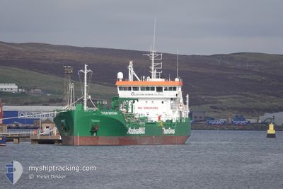
THUN BRITAIN
Tanker

Current Trip
| Trip Time | 1 day |
|---|---|
| Trip Distance | 359.02 морская миля |
| AVG Speed | 10.3 Узлы |
| MAX Speed | 13.9 Узлы |
| Осадка | 3.8 м |
| AVG Wind | 6.9 knots |
| MAX Wind | 16 knots |
| MIN Temp | 4.8°C / 40.64°F |
| MAX Temp | 8.3°C / 46.94°F |
| Позиция Получена | 1 d тому назад |
Current Position
| Долгота | --- |
|---|---|
| Широта | --- |
| Статус | Under way using engine |
| Скорость | 11.6 Узлы |
| Курс | 50.7° |
| Район | North Sea |
| Станция | T-AIS |
| Позиция Получена | 1 d тому назад |
Information
The current position of THUN BRITAIN is in North Sea with coordinates 58.90171° / -2.48512° as reported on 2025-03-17 03:30 by AIS to our vessel tracker app. The vessel's current speed is 11.6 Узлы and is currently inside the port of LERWICK.
The vessel THUN BRITAIN (IMO: 9897482, MMSI: 244329000) is a Tanker It's sailing under the flag of [NL] Netherlands.
In this page you can find informations about the vessels current position, last detected port calls, and current voyage information. If the vessels is not in coverage by AIS you will find the latest position.
The current position of THUN BRITAIN is detected by our AIS receivers and we are not responsible for the reliability of the data. The last position was recorded while the vessel was in Coverage by the Ais receivers of our vessel tracking app.
The current draught of THUN BRITAIN as reported by AIS is 3.8 meters
Weather
| Temperature | 5.4°C / 41.72°F |
|---|---|
| Wind Speed | 5 knots |
| Direction | 203° SSW |
| Pressure | 1028.2 hPa |
| Humidity | 75.2 % |
| Cloud Coverage | 52 % |


Featured Company
Last Port Calls
| Port | Arrival | Departure | Time In Port |
|---|---|---|---|
| 2025-03-17 16:08 | |||
| 2025-03-15 15:56 | 2025-03-15 23:30 | 7 h | |
| 2025-03-14 09:03 | 2025-03-14 15:30 | 6 h | |
| 2025-03-12 04:46 | 2025-03-13 05:33 | 1 d | |
| 2025-03-09 16:32 | 2025-03-10 09:45 | 17 h | |
| 2025-03-07 17:07 | 2025-03-08 12:24 | 19 h | |
| 2025-03-05 19:44 | 2025-03-06 17:49 | 22 h | |
| 2025-03-03 08:58 | 2025-03-03 22:55 | 13 h | |
| 2025-02-28 01:39 | 2025-03-01 02:22 | 1 d | |
| 2025-02-25 14:24 | 2025-02-26 01:51 | 11 h |
Last Trips
| Origin | Departure | Destination | Arrival | Distance | |
|---|---|---|---|---|---|
| 2025-03-15 23:30 | 2025-03-17 16:08 | 359.02 морская миля | |||
| 2025-03-14 15:30 | 2025-03-15 15:56 | 230.30 морская миля | |||
| 2025-03-13 05:33 | 2025-03-14 09:03 | 262.61 морская миля | |||
| 2025-03-10 09:45 | 2025-03-12 04:46 | 204.38 морская миля | |||
| 2025-03-08 12:24 | 2025-03-09 16:32 | 333.70 морская миля | |||
| 2025-03-06 17:49 | 2025-03-07 17:07 | 259.55 морская миля | |||
| 2025-03-03 22:55 | 2025-03-05 19:44 | 441.21 морская миля | |||
| 2025-03-01 02:22 | 2025-03-03 08:58 | 435.78 морская миля | |||
| 2025-02-26 01:51 | 2025-02-28 01:39 | 440.16 морская миля | |||
| 2025-02-23 14:10 | 2025-02-25 14:24 | 426.80 морская миля |
Events
| Время | Событие | Детали | Позиция / Направление | Информация |
|---|---|---|---|---|
| 2025-03-17 16:29 | Окончание движения |
60.16575 / -1.15678
[GB] LERWICK
|
Скорость: Курс: 175° |
|
| 2025-03-17 16:08 | Начало движения |
60.16106 / -1.14675
[GB] LERWICK
|
Скорость: 4.4 kn Курс: 309° |
|
| 2025-03-17 16:08 | Порт |
|
60.16106 / -1.14675
[GB] LERWICK
|
Скорость: Курс: 349° |
| 2025-03-17 11:12 | Окончание движения | 0.52 nm, South East of LERWICK |
60.15830 / -1.14391
GB LER
|
Скорость: 0.1 kn Курс: 349° |
| 2025-03-17 03:36 | Статус изменился | Default Under way using engine |
58.91482 / -2.45595
GB LER
|
Скорость: 11.6 kn Курс: 50.7° |
| 2025-03-17 03:30 | Вне покрытия |
58.90171 / -2.48512
North Sea
|
Скорость: 11.6 kn Курс: 50.7° |
|
| 2025-03-17 00:31 | Обнаружено в море | United Kingdom part of the North Sea |
58.70979 / -3.40184
North Sea
|
Скорость: 12.9 kn Курс: 86.2° |
| 2025-03-16 22:51 | Пункт назначения изменился | GB LER GB LCC |
58.74630 / -4.09008
GB LER
|
Скорость: 12.8 kn Курс: 97° |
| 2025-03-16 22:51 | ETA изменился | 2026/02/17 06:00 2026/02/16 06:00 |
58.74630 / -4.09008
GB LER
|
Скорость: 12.8 kn Курс: 97° |
| 2025-03-16 21:57 | Статус изменился | Under way using engine Default |
58.77757 / -4.45887
GB LCC
|
Скорость: 13.5 kn Курс: 101° |