
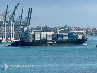
SEABOARD EXPLORER
Container Ship
Current Trip
| Time Travelled | 2 days |
|---|---|
| Remaining Time | 1 h, 41 mins |
| Distance Travelled | 1169.25 морская миля |
| Remaining Distance | 39.22 морская миля |
| AVG Speed | 19.5 Узлы |
| MAX Speed | 21.2 Узлы |
| AVG Wind | 7.2 knots |
| MAX Wind | 14.3 knots |
| MIN Temp | 22°C / 71.6°F |
| MAX Temp | 27°C / 80.6°F |
| Осадка | 9.7 м |
| Позиция Получена | Сейчас |
Current Position
| Долгота | --- |
|---|---|
| Широта | --- |
| Статус | Under way using engine |
| Скорость | 19.9 Узлы |
| Курс | 39.7° |
| Район | North Atlantic Ocean |
| Станция | T-AIS |
| Позиция Получена | Сейчас |
Information
The current position of SEABOARD EXPLORER is in North Atlantic Ocean with coordinates 25.24430° / -80.00221° as reported on 2025-02-27 15:28 by AIS to our vessel tracker app. The vessel's current speed is 19.9 Узлы and is heading at the port of MIAMI. The estimated time of arrival as calculated by MyShipTracking vessel tracking app is 2025-02-27 17:10 LT
The vessel SEABOARD EXPLORER (IMO: 9347267, MMSI: 636020226) is a Container Ship that was built in 2008 ( 17 лет ). It's sailing under the flag of [LR] Liberia.
In this page you can find informations about the vessels current position, last detected port calls, and current voyage information. If the vessels is not in coverage by AIS you will find the latest position.
The current position of SEABOARD EXPLORER is detected by our AIS receivers and we are not responsible for the reliability of the data. The last position was recorded while the vessel was in Coverage by the Ais receivers of our vessel tracking app.
The current draught of SEABOARD EXPLORER as reported by AIS is 9.7 meters
Weather
| Temperature | 24.1°C / 75.38°F |
|---|---|
| Wind Speed | 9 knots |
| Direction | 176° S |
| Pressure | 1017.9 hPa |
| Humidity | 63.8 % |
| Cloud Coverage | 2 % |
Featured Company
Last Port Calls
| Port | Arrival | Departure | Time In Port |
|---|---|---|---|
| 2025-02-24 11:43 | 2025-02-25 03:16 | 15 h | |
| 2025-02-17 19:14 | 2025-02-18 08:50 | 13 h | |
| 2025-02-11 20:11 | 2025-02-12 12:23 | 16 h | |
| 2025-02-09 22:15 | 2025-02-10 11:55 | 13 h | |
| 2025-02-07 02:06 | 2025-02-08 04:40 | 1 d | |
| 2025-02-03 13:19 | 2025-02-04 09:12 | 19 h | |
| 2025-01-27 13:54 | 2025-01-28 09:50 | 19 h | |
| 2025-01-22 12:17 | 2025-01-22 18:43 | 6 h | |
| 2025-01-17 02:24 | 2025-01-18 20:29 | 1 d | |
| 2025-01-13 11:40 | 2025-01-14 09:15 | 21 h |
Most Visited Ports (Last year)
| Port | Arrivals | |
|---|---|---|
| 19 | ||
| 9 | ||
| 9 | ||
| 5 | ||
| 4 | ||
| 3 |
Last Trips
| Origin | Departure | Destination | Arrival | Distance | |
|---|---|---|---|---|---|
| 2025-02-18 03:50 | 2025-02-24 06:43 | 1818.28 морская миля | |||
| 2025-02-12 07:23 | 2025-02-17 14:14 | 1553.36 морская миля | |||
| 2025-02-10 06:55 | 2025-02-11 15:11 | 551.86 морская миля | |||
| 2025-02-07 23:40 | 2025-02-09 17:15 | 734.76 морская миля | |||
| 2025-02-04 04:12 | 2025-02-06 21:06 | 1208.86 морская миля | |||
| 2025-01-28 04:50 | 2025-02-03 08:19 | 1822.08 морская миля | |||
| 2025-01-22 13:43 | 2025-01-27 08:54 | 1557.02 морская миля | |||
| 2025-01-18 15:29 | 2025-01-22 07:17 | 1216.41 морская миля | |||
| 2025-01-14 04:15 | 2025-01-16 21:24 | 1201.41 морская миля | |||
| 2025-01-08 00:22 | 2025-01-13 06:40 | 1655.60 морская миля |
Events
| Время | Событие | Детали | Позиция / Направление | Информация |
|---|---|---|---|---|
| 2025-02-27 12:57 | Осадка изменилась | 9.7 10 |
24.55408 / -80.56524
USMIA
|
Скорость: 21.1 kn Курс: 35.5° |
| 2025-02-27 12:57 | Пункт назначения изменился | USMIA PAMIT |
24.55408 / -80.56524
USMIA
|
Скорость: 21.1 kn Курс: 35.5° |
| 2025-02-27 12:57 | ETA изменился | 2025/02/28 04:00 2025/02/23 21:00 |
24.55408 / -80.56524
USMIA
|
Скорость: 21.1 kn Курс: 35.5° |
| 2025-02-27 12:30 | Обнаружено в море | United States part of the North Atlantic Ocean |
24.42091 / -80.66937
North Atlantic Ocean
|
Скорость: 20.8 kn Курс: 36.3° |
| 2025-02-27 12:30 | Статус изменился | Under way using engine Default |
24.42091 / -80.66937
PAMIT
|
Скорость: 20.6 kn Курс: 39° |
| 2025-02-27 12:30 | В покрытии |
24.42091 / -80.66937
North Atlantic Ocean
|
Скорость: 20.8 kn Курс: 36.3° |
|
| 2025-02-25 04:24 | Статус изменился | Default Under way using engine |
9.65107 / -79.95754
PAMIT
|
Скорость: 18.9 kn Курс: 342.1° |
| 2025-02-25 04:19 | Вне покрытия |
9.62588 / -79.94871
Caribbean Sea
|
Скорость: 18.9 kn Курс: 342.1° |
|
| 2025-02-25 03:52 | Статус изменился | Under way using engine Moored |
9.49456 / -79.90665
PAMIT
|
Скорость: 17.8 kn Курс: 349.9° |
| 2025-02-25 03:16 | ПОРТ ОТПРАВЛЕНИЯ |
|
9.36643 / -79.88927
PAMIT
|
Скорость: 5.7 kn Курс: 319° |