
SEA BEAUTY
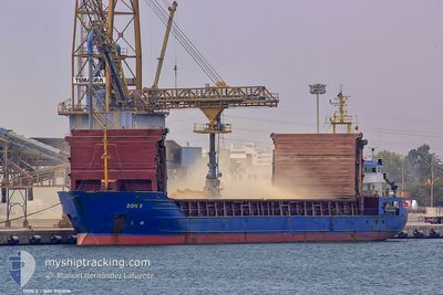
General Cargo
Current Trip
| Time Travelled | 7 days |
|---|---|
| Remaining Time | --- |
| Distance Travelled | 1648.17 морская миля |
| Remaining Distance | --- |
| AVG Speed | 9.5 Узлы |
| MAX Speed | 12.5 Узлы |
| AVG Wind | 7.6 knots |
| MAX Wind | 23.1 knots |
| MIN Temp | 12.9°C / 55.22°F |
| MAX Temp | 20.2°C / 68.36°F |
| Осадка | 5.5 м |
| Позиция Получена | 7 m тому назад |
Current Position
| Долгота | 13.30009° |
|---|---|
| Широта | 45.64076° |
| Статус | At anchor |
| Скорость | |
| Курс | 306° |
| Район | Adriatic Sea |
| Станция | T-AIS |
| Позиция Получена | 7 m тому назад |
Info
Information
The current position of SEA BEAUTY is in Adriatic Sea with coordinates 45.64076° / 13.30009° as reported on 2024-05-05 13:27 by AIS to our vessel tracker app. The vessel's current speed is 0 Узлы
The vessel SEA BEAUTY (IMO: 9151096, MMSI: 312667000) is a General Cargo that was built in 1996 ( 28 лет ). It's sailing under the flag of [BZ] Belize.
In this page you can find informations about the vessels current position, last detected port calls, and current voyage information. If the vessels is not in coverage by AIS you will find the latest position.
The current position of SEA BEAUTY is detected by our AIS receivers and we are not responsible for the reliability of the data. The last position was recorded while the vessel was in Coverage by the Ais receivers of our vessel tracking app.
The current draught of SEA BEAUTY as reported by AIS is 5.5 meters
Weather
| Temperature | 17.2°C / 62.96°F |
|---|---|
| Wind Speed | 10 knots |
| Direction | 192° SSW |
| Pressure | 1014.9 hPa |
| Humidity | 80.6 % |
| Cloud Coverage | 100 % |
Featured Company
Last Port Calls
| Port | Arrival | Departure | Time In Port |
|---|---|---|---|
| 2024-04-27 15:40 | 2024-04-27 18:05 | 2 h | |
| 2024-04-25 00:21 | 2024-04-26 02:13 | 1 d | |
| 2024-04-21 17:08 |
Last Trips
| Origin | Departure | Destination | Arrival | Distance | |
|---|---|---|---|---|---|
| 2024-04-26 03:13 | 2024-04-27 17:40 | 328.62 морская миля | |||
| 2024-04-21 18:08 | 2024-04-25 01:21 | 740.76 морская миля |
Events
| Время | Событие | Детали | Позиция / Направление | Информация |
|---|---|---|---|---|
| 2024-05-05 06:45 | Окончание движения | 9.06 nm, South of PORTO NOGARO |
45.64323 / 13.30024
ITPNG
|
Скорость: 0.2 kn Курс: 197° |
| 2024-05-05 06:32 | Статус изменился | At anchor Under way using engine |
45.64198 / 13.29858
ITPNG
|
Скорость: 0.5 kn Курс: 114° |
| 2024-05-05 05:13 | Изменение морского района | Italian part of the Adriatic Sea Croatian part of the Adriatic Sea |
45.48776 / 13.23600
Adriatic Sea
ITPNG
|
Скорость: 6.6 kn Курс: 14.2° |
| 2024-05-04 23:16 | В покрытии |
44.59910 / 13.68633
Adriatic Sea
ITPNG
|
Скорость: 9.5 kn Курс: 327.7° |
|
| 2024-05-04 21:54 | Вне покрытия |
44.41673 / 13.84746
Adriatic Sea
ITPNG
|
Скорость: 9.2 kn Курс: 329.9° |
|
| 2024-05-04 20:51 | В покрытии |
44.28222 / 13.97765
Adriatic Sea
ITPNG
|
Скорость: 9.4 kn Курс: 327.3° |
|
| 2024-05-04 19:28 | Вне покрытия |
44.10046 / 14.14644
Adriatic Sea
ITPNG
|
Скорость: 9.4 kn Курс: 319.6° |
|
| 2024-05-04 15:13 | В покрытии |
43.59628 / 14.72078
Adriatic Sea
ITPNG
|
Скорость: 9.4 kn Курс: 319.9° |
|
| 2024-05-04 08:07 | Вне покрытия |
42.76042 / 15.67088
Adriatic Sea
ITPNG
|
Скорость: 9.1 kn Курс: 316.7° |
|
| 2024-05-04 02:57 | Изменение морского района | Croatian part of the Adriatic Sea Italian part of the Adriatic Sea |
42.17539 / 16.38245
Adriatic Sea
ITPNG
|
Скорость: 9.2 kn Курс: 314.7° |