
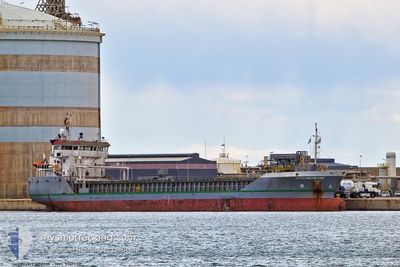
SCHOUWENBANK
General Cargo
Current Trip
| Trip Time | 4 days |
|---|---|
| Trip Distance | 1006.89 морская миля |
| AVG Speed | 7.9 Узлы |
| MAX Speed | 11.3 Узлы |
| Осадка | 6.4 м |
| AVG Wind | 11.7 knots |
| MAX Wind | 19 knots |
| MIN Temp | 8.2°C / 46.76°F |
| MAX Temp | 14.7°C / 58.46°F |
| Позиция Получена | 14 h, 13 m тому назад |
Current Position
| Долгота | -6.89037° |
|---|---|
| Широта | 55.23971° |
| Статус | Under way using engine |
| Скорость | 10 Узлы |
| Курс | 235.1° |
| Район | Inner Seas off the West Coast of Scotland |
| Станция | T-AIS |
| Позиция Получена | 14 h, 13 m тому назад |
Info
Information
The current position of SCHOUWENBANK is in Inner Seas off the West Coast of Scotland with coordinates 55.23971° / -6.89037° as reported on 2024-05-19 21:00 by AIS to our vessel tracker app. The vessel's current speed is 10 Узлы and is currently inside the port of LONDONDERRY.
The vessel SCHOUWENBANK (IMO: 9361732, MMSI: 245594000) is a General Cargo that was built in 2007 ( 17 лет ). It's sailing under the flag of [NL] Netherlands.
In this page you can find informations about the vessels current position, last detected port calls, and current voyage information. If the vessels is not in coverage by AIS you will find the latest position.
The current position of SCHOUWENBANK is detected by our AIS receivers and we are not responsible for the reliability of the data. The last position was recorded while the vessel was in Coverage by the Ais receivers of our vessel tracking app.
The current draught of SCHOUWENBANK as reported by AIS is 6.4 meters
Weather
| Temperature | 21°C / 69.8°F |
|---|---|
| Wind Speed | 2 knots |
| Direction | 142° SE |
| Pressure | 1014.3 hPa |
| Humidity | 57.7 % |
| Cloud Coverage | 24 % |
Featured Company
Last Port Calls
| Port | Arrival | Departure | Time In Port |
|---|---|---|---|
| 2024-05-20 00:18 | |||
| 2024-05-13 14:14 | 2024-05-15 09:27 | 1 d | |
| 2024-05-10 08:03 | 2024-05-11 09:49 | 1 d | |
| 2024-05-04 06:41 | 2024-05-04 07:25 | 43 m | |
| 2024-05-03 08:35 | 2024-05-04 06:10 | 21 h | |
| 2024-05-03 07:34 | 2024-05-03 08:12 | 38 m | |
| 2024-05-02 18:51 | 2024-05-03 04:58 | 10 h | |
| 2024-04-25 08:26 | 2024-04-25 12:53 | 4 h | |
| 2024-04-12 10:02 | 2024-04-17 19:14 | 5 d | |
| 2024-04-08 07:24 | 2024-04-11 13:27 | 3 d |
Most Visited Ports (Last year)
| Port | Arrivals | |
|---|---|---|
| 5 | ||
| 4 | ||
| 4 | ||
| 3 | ||
| 2 | ||
| 2 |
Last Trips
| Origin | Departure | Destination | Arrival | Distance | |
|---|---|---|---|---|---|
| 2024-05-15 09:27 | 2024-05-20 00:18 | 1006.89 морская миля | |||
| 2024-05-11 09:49 | 2024-05-13 14:14 | 404.34 морская миля | |||
| 2024-05-04 07:25 | 2024-05-10 08:03 | 1322.47 морская миля | |||
| 2024-05-04 06:10 | 2024-05-04 06:41 | 1.84 морская миля | |||
| 2024-05-03 08:12 | 2024-05-03 08:35 | 1.96 морская миля | |||
| 2024-04-25 12:53 | 2024-05-03 07:34 | 1367.42 морская миля | |||
| 2024-04-25 12:53 | 2024-05-02 18:51 | 1341.40 морская миля | |||
| 2024-04-17 19:14 | 2024-04-25 08:26 | 1634.10 морская миля | |||
| 2024-04-11 13:27 | 2024-04-12 10:02 | 183.62 морская миля | |||
| 2024-04-02 13:35 | 2024-04-08 07:24 | 1494.06 морская миля |
Events
| Время | Событие | Детали | Позиция / Направление | Информация |
|---|---|---|---|---|
| 2024-05-19 23:19 | Окончание движения |
55.04325 / -7.26128
[GB] LONDONDERRY
|
Скорость: 0.2 kn Курс: 220° |
|
| 2024-05-19 23:18 | Порт |
|
55.04325 / -7.26128
[GB] LONDONDERRY
|
Скорость: 1.2 kn Курс: 224° |
| 2024-05-19 21:07 | Статус изменился | Default Under way using engine |
55.22613 / -6.91113
UKLDY
|
Скорость: 10 kn Курс: 235.1° |
| 2024-05-19 21:00 | Изменение морского района | Irish part of the Inner Seas off the West Coast of Scotland United Kingdom part of the Inner Seas off the West Coast of Scotland |
55.23971 / -6.89037
Inner Seas off the West Coast of Scotland
UKLDY
|
Скорость: 10 kn Курс: 235.1° |
| 2024-05-19 21:00 | Статус изменился | Under way using engine Default |
55.23971 / -6.89037
UKLDY
|
Скорость: 10.2 kn Курс: 244° |
| 2024-05-19 21:00 | Вне покрытия |
55.23971 / -6.89037
Inner Seas off the West Coast of Scotland
UKLDY
|
Скорость: 10 kn Курс: 235.1° |
|
| 2024-05-19 20:27 | Статус изменился | Default Under way using engine |
55.28198 / -6.73928
UKLDY
|
Скорость: 8.5 kn Курс: 245.5° |
| 2024-05-19 19:21 | Начало движения | 7.2 nm, North of PORTBALLINTRAE |
55.33732 / -6.56869
UKLDY
|
Скорость: 4 kn Курс: 243° |
| 2024-05-19 19:16 | Окончание движения | 7.29 nm, North of PORTBALLINTRAE |
55.33896 / -6.56719
UKLDY
|
Скорость: 0.3 kn Курс: 260° |
| 2024-05-19 14:06 | Статус изменился | Under way using engine Default |
55.15165 / -5.79403
UKLDY
|
Скорость: 10.2 kn Курс: 332° |