
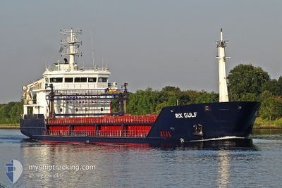
RIX GULF
General Cargo
Current Trip
| Time Travelled | 3 days |
|---|---|
| Remaining Time | 4 days |
| Distance Travelled | 736.12 морская миля |
| Remaining Distance | 871.19 морская миля |
| AVG Speed | 8.2 Узлы |
| MAX Speed | 11.1 Узлы |
| AVG Wind | 10.5 knots |
| MAX Wind | 18.3 knots |
| MIN Temp | 12.2°C / 53.96°F |
| MAX Temp | 15.2°C / 59.36°F |
| Осадка | 5.9 м |
| Позиция Получена | 22 m тому назад |
Current Position
| Долгота | 3.03340° |
|---|---|
| Широта | 52.07806° |
| Статус | Under way using engine |
| Скорость | 7.2 Узлы |
| Курс | 43.2° |
| Район | North Sea |
| Станция | T-AIS |
| Позиция Получена | 22 m тому назад |
Info
Information
The current position of RIX GULF is in North Sea with coordinates 52.07806° / 3.03340° as reported on 2024-05-21 06:39 by AIS to our vessel tracker app. The vessel's current speed is 7.2 Узлы and is heading at the port of GDYNIA. The estimated time of arrival as calculated by MyShipTracking vessel tracking app is 2024-05-25 15:18 LT
The vessel RIX GULF (IMO: 9396701, MMSI: 209823000) is a General Cargo that was built in 2008 ( 16 лет ). It's sailing under the flag of [CY] Cyprus.
In this page you can find informations about the vessels current position, last detected port calls, and current voyage information. If the vessels is not in coverage by AIS you will find the latest position.
The current position of RIX GULF is detected by our AIS receivers and we are not responsible for the reliability of the data. The last position was recorded while the vessel was in Coverage by the Ais receivers of our vessel tracking app.
The current draught of RIX GULF as reported by AIS is 5.9 meters
Weather
| Temperature | 13.5°C / 56.3°F |
|---|---|
| Wind Speed | 6 knots |
| Direction | 75° ENE |
| Pressure | 1008.5 hPa |
| Humidity | 92.3 % |
| Cloud Coverage | 82 % |
Featured Company
Last Port Calls
| Port | Arrival | Departure | Time In Port |
|---|---|---|---|
| 2024-05-12 09:13 | 2024-05-17 17:46 | 5 d | |
| 2024-05-07 19:51 | 2024-05-09 19:25 | 1 d | |
| 2024-05-03 10:38 | 2024-05-04 16:47 | 1 d | |
| 2024-05-02 21:23 | 2024-05-02 22:51 | 1 h | |
| 2024-04-30 00:48 | 2024-05-02 20:03 | 2 d | |
| 2024-04-23 23:05 | 2024-04-25 20:50 | 1 d | |
| 2024-04-22 07:18 | 2024-04-23 08:30 | 1 d | |
| 2024-04-13 10:15 | 2024-04-17 09:13 | 3 d | |
| 2024-04-10 16:22 | 2024-04-13 06:31 | 2 d | |
| 2024-03-30 12:19 | 2024-04-04 13:55 | 5 d |
Last Trips
| Origin | Departure | Destination | Arrival | Distance | |
|---|---|---|---|---|---|
| 2024-05-09 19:25 | 2024-05-12 09:13 | 563.77 морская миля | |||
| 2024-05-04 16:47 | 2024-05-07 19:51 | 607.65 морская миля | |||
| 2024-05-02 22:51 | 2024-05-03 10:38 | 109.73 морская миля | |||
| 2024-05-02 20:03 | 2024-05-02 21:23 | 8.99 морская миля | |||
| 2024-04-25 20:50 | 2024-04-30 00:48 | 765.88 морская миля | |||
| 2024-04-23 08:30 | 2024-04-23 23:05 | 132.82 морская миля | |||
| 2024-04-17 09:13 | 2024-04-22 07:18 | 954.80 морская миля | |||
| 2024-04-13 06:31 | 2024-04-13 10:15 | 31.81 морская миля | |||
| 2024-04-04 13:55 | 2024-04-10 16:22 | 920.48 морская миля | |||
| 2024-03-29 15:17 | 2024-03-30 12:19 | 137.30 морская миля |
Events
| Время | Событие | Детали | Позиция / Направление | Информация |
|---|---|---|---|---|
| 2024-05-21 06:41 | Статус изменился | Default Under way using engine |
52.07978 / 3.03597
PLGDY
|
Скорость: 7.2 kn Курс: 43.2° |
| 2024-05-21 06:27 | Статус изменился | Under way using engine Default |
52.06031 / 3.00675
PLGDY
|
Скорость: 7.3 kn Курс: 41° |
| 2024-05-21 05:41 | Статус изменился | Default Under way using engine |
51.98946 / 2.90064
PLGDY
|
Скорость: 7.8 kn Курс: 41.9° |
| 2024-05-21 03:58 | Обнаружено в море | Dutch part of the North Sea |
51.80983 / 2.64558
North Sea
PLGDY
|
Скорость: 8.8 kn Курс: 36.1° |
| 2024-05-21 01:45 | Статус изменился | Under way using engine Default |
51.52536 / 2.32450
PLGDY
|
Скорость: 9.8 kn Курс: 35° |
| 2024-05-21 01:37 | Статус изменился | Default Under way using engine |
51.50644 / 2.30266
PLGDY
|
Скорость: 9.5 kn Курс: 33.7° |
| 2024-05-21 01:29 | Изменение морского района | Belgian part of the North Sea French part of the North Sea |
51.48850 / 2.28265
North Sea
PLGDY
|
Скорость: 9.5 kn Курс: 33.7° |
| 2024-05-21 01:29 | Статус изменился | Under way using engine Default |
51.48850 / 2.28265
PLGDY
|
Скорость: 9 kn Курс: 33° |
| 2024-05-21 01:23 | Статус изменился | Default Under way using engine |
51.47500 / 2.26833
PLGDY
|
Скорость: 9.7 kn Курс: 33.9° |
| 2024-05-21 01:20 | Статус изменился | Under way using engine Default |
51.46878 / 2.26169
PLGDY
|
Скорость: 9.7 kn Курс: 32° |