
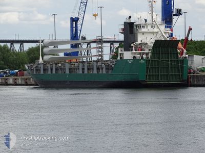
POLARIS
Ro-Ro Cargo
Current Trip
| Time Travelled | 3 days |
|---|---|
| Remaining Time | --- |
| Distance Travelled | 1063.97 морская миля |
| Remaining Distance | --- |
| AVG Speed | 11.5 Узлы |
| MAX Speed | 15.1 Узлы |
| AVG Wind | 10.1 knots |
| MAX Wind | 29.1 knots |
| MIN Temp | 12.6°C / 54.68°F |
| MAX Temp | 19.7°C / 67.46°F |
| Осадка | 5.1 м |
| Позиция Получена | Сейчас |
Current Position
| Долгота | 10.15973° |
|---|---|
| Широта | 37.67289° |
| Статус | Under way using engine |
| Скорость | 11.1 Узлы |
| Курс | 272.5° |
| Район | Mediterranean Sea - Western Basin |
| Станция | T-AIS |
| Позиция Получена | Сейчас |
Info
Information
The current position of POLARIS is in Mediterranean Sea - Western Basin with coordinates 37.67289° / 10.15973° as reported on 2024-05-12 15:57 by AIS to our vessel tracker app. The vessel's current speed is 11.1 Узлы and is heading at the port of AVEIRO. The estimated time of arrival as calculated by MyShipTracking vessel tracking app is 2024-05-18 08:00 LT
The vessel POLARIS (IMO: 8716100, MMSI: 305004000) is a Ro-Ro Cargo that was built in 1988 ( 36 лет ). It's sailing under the flag of [AG] Antigua Barbuda.
In this page you can find informations about the vessels current position, last detected port calls, and current voyage information. If the vessels is not in coverage by AIS you will find the latest position.
The current position of POLARIS is detected by our AIS receivers and we are not responsible for the reliability of the data. The last position was recorded while the vessel was in Coverage by the Ais receivers of our vessel tracking app.
The current draught of POLARIS as reported by AIS is 5.1 meters
Weather
| Temperature | 19.4°C / 66.92°F |
|---|---|
| Wind Speed | 14 knots |
| Direction | 95° E |
| Pressure | 1016.2 hPa |
| Humidity | 76 % |
| Cloud Coverage | 4 % |
Featured Company
Last Port Calls
| Port | Arrival | Departure | Time In Port |
|---|---|---|---|
| 2024-05-07 12:03 | 2024-05-08 17:44 | 1 d | |
| 2024-04-26 05:44 | 2024-04-29 20:08 | 3 d | |
| 2024-04-20 04:47 | 2024-04-21 23:37 | 1 d | |
| 2024-04-02 17:53 | 2024-04-05 12:06 | 2 d | |
| 2024-03-29 14:10 | 2024-03-29 21:04 | 6 h | |
| 2024-03-27 08:57 | 2024-03-28 14:12 | 1 d | |
| 2024-03-25 20:42 | 2024-03-26 15:00 | 18 h | |
| 2024-03-16 07:56 | 2024-03-19 09:16 | 3 d | |
| 2024-03-14 17:18 | 2024-03-15 19:29 | 1 d | |
| 2024-03-09 10:53 | 2024-03-12 17:56 | 3 d |
Last Trips
| Origin | Departure | Destination | Arrival | Distance | |
|---|---|---|---|---|---|
| 2024-04-29 23:08 | 2024-05-07 15:03 | 804.50 морская миля | |||
| 2024-04-22 02:37 | 2024-04-26 08:44 | 1043.49 морская миля | |||
| 2024-04-05 14:06 | 2024-04-20 07:47 | 3056.48 морская миля | |||
| 2024-03-29 22:04 | 2024-04-02 19:53 | 850.63 морская миля | |||
| 2024-03-28 15:12 | 2024-03-29 15:10 | 221.63 морская миля | |||
| 2024-03-26 16:00 | 2024-03-27 09:57 | 171.67 морская миля | |||
| 2024-03-19 09:16 | 2024-03-25 21:42 | 1170.55 морская миля | |||
| 2024-03-15 19:29 | 2024-03-16 07:56 | 65.73 морская миля | |||
| 2024-03-12 18:56 | 2024-03-14 17:18 | 482.78 морская миля | |||
| 2024-03-05 20:48 | 2024-03-09 11:53 | 829.95 морская миля |
Events
| Время | Событие | Детали | Позиция / Направление | Информация |
|---|---|---|---|---|
| 2024-05-12 10:50 | Обнаружено в море | Tunisian part of the Mediterranean Sea - Western Basin |
37.55232 / 11.40318
Mediterranean Sea - Western Basin
PT AVE
|
Скорость: 11.5 kn Курс: 280.2° |
| 2024-05-12 09:02 | Изменение морского района | Italian part of the Mediterranean Sea - Western Basin Italian part of the Mediterranean Sea - Eastern Basin |
37.50449 / 11.83921
Mediterranean Sea - Western Basin
PT AVE
|
Скорость: 11.7 kn Курс: 277.8° |
| 2024-05-12 05:34 | Статус изменился | Under way using engine Default |
37.43306 / 12.58766
PT AVE
|
Скорость: 8.2 kn Курс: 276° |
| 2024-05-12 05:20 | Статус изменился | Default Under way using engine |
37.42951 / 12.62522
PT AVE
|
Скорость: 7.9 kn Курс: 277.1° |
| 2024-05-12 04:08 | Статус изменился | Under way using engine Default |
37.40492 / 12.84292
PT AVE
|
Скорость: 9 kn Курс: 298° |
| 2024-05-12 03:52 | Статус изменился | Default Under way using engine |
37.38167 / 12.89500
PT AVE
|
Скорость: 11.6 kn Курс: 298.5° |
| 2024-05-12 03:52 | Статус изменился | Under way using engine Default |
37.38087 / 12.89702
PT AVE
|
Скорость: 8.6 kn Курс: 300° |
| 2024-05-12 03:37 | В покрытии |
37.38087 / 12.89702
Mediterranean Sea - Eastern Basin
PT AVE
|
Скорость: 11.6 kn Курс: 298.5° |
|
| 2024-05-12 00:49 | Статус изменился | Default Under way using engine |
37.13025 / 13.46556
PT AVE
|
Скорость: 10.8 kn Курс: 300.7° |
| 2024-05-12 00:42 | Вне покрытия |
37.12006 / 13.48688
Mediterranean Sea - Eastern Basin
PT AVE
|
Скорость: 10.8 kn Курс: 300.7° |