

POLARIS
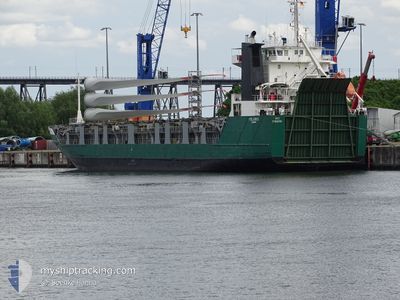
Ro-Ro Cargo

Current Trip
| Time Travelled | 5 days |
|---|---|
| Remaining Time | --- |
| Distance Travelled | 1246.96 nm |
| Remaining Distance | --- |
| AVG Speed | 10 Knots |
| MAX Speed | 11.9 Knots |
| AVG Wind | 12 knots |
| MAX Wind | 35.3 knots |
| MIN Temp | 8.3°C / 46.94°F |
| MAX Temp | 18.8°C / 65.84°F |
| Dybgang | 5.3 m |
| Position Modtaget | 2 d siden |
Current Position
| Longitude | --- |
|---|---|
| Latitude | --- |
| Status | Under way using engine |
| Fart | 10.5 Knots |
| Kurs | 276° |
| Område | Mediterranean Sea - Western Basin |
| Station | T-AIS |
| Position Modtaget | 2 d siden |
Information
The current position of POLARIS is in Mediterranean Sea - Western Basin with coordinates 37.60827° / 11.81410° as reported on 2025-03-25 12:13 by AIS to our vessel tracker app. The vessel's current speed is 10.5 Knots and is heading at the port of ROUEN. The estimated time of arrival as calculated by MyShipTracking vessel tracking app is 2025-04-03 14:00 LT
The vessel POLARIS (IMO: 8716100, MMSI: 305004000) is a Ro-Ro Cargo that was built in 1988 ( 37 år gamle ). It's sailing under the flag of [AG] Antigua Barbuda.
In this page you can find informations about the vessels current position, last detected port calls, and current voyage information. If the vessels is not in coverage by AIS you will find the latest position.
The current position of POLARIS is detected by our AIS receivers and we are not responsible for the reliability of the data. The last position was recorded while the vessel was in Coverage by the Ais receivers of our vessel tracking app.
The current draught of POLARIS as reported by AIS is 5.3 meters
Weather
| Temperature | 16.4°C / 61.52°F |
|---|---|
| Wind Speed | 12 knots |
| Direction | 276° W |
| Pressure | 1015.2 hPa |
| Humidity | 70.4 % |
| Cloud Coverage | 29 % |


Featured Company
Last Port Calls
| Port | Arrival | Departure | Time In Port |
|---|---|---|---|
| 2025-03-16 08:04 | 2025-03-22 04:28 | 5 d | |
| 2025-03-11 23:10 | 2025-03-13 03:23 | 1 d | |
| 2025-03-10 00:28 | 2025-03-10 09:41 | 9 h | |
| 2025-03-06 07:43 | 2025-03-06 16:46 | 9 h | |
| 2025-02-17 10:57 | 2025-02-19 14:21 | 2 d | |
| 2025-02-12 11:11 | 2025-02-12 19:17 | 8 h | |
| 2025-02-07 06:11 | 2025-02-08 14:12 | 1 d | |
| 2025-01-21 10:12 | 2025-01-21 19:02 | 8 h | |
| 2025-01-11 17:32 | 2025-01-13 19:24 | 2 d | |
| 2025-01-09 09:13 | 2025-01-10 16:31 | 1 d |
Last Trips
| Origin | Departure | Destination | Arrival | Distance | |
|---|---|---|---|---|---|
| 2025-03-13 03:23 | 2025-03-16 08:04 | 550.98 nm | |||
| 2025-03-10 09:41 | 2025-03-11 23:10 | 326.10 nm | |||
| 2025-03-06 16:46 | 2025-03-10 00:28 | 795.00 nm | |||
| 2025-02-19 14:21 | 2025-03-06 07:43 | 3042.07 nm | |||
| 2025-02-12 19:17 | 2025-02-17 10:57 | 802.79 nm | |||
| 2025-02-08 14:12 | 2025-02-12 11:11 | 623.57 nm | |||
| 2025-01-21 19:02 | 2025-02-07 06:11 | 1969.50 nm | |||
| 2025-01-13 19:24 | 2025-01-21 10:12 | 1813.99 nm | |||
| 2025-01-10 16:31 | 2025-01-11 17:32 | 210.58 nm | |||
| 2025-01-07 17:15 | 2025-01-09 09:13 | 158.70 nm |
Events
| Tid | Hændelsen | Detaljer | Position / Dest | Info |
|---|---|---|---|---|
| 2025-03-25 12:21 | Status er ændret | Default Under way using engine |
37.61050 / 11.78478
FRURO
|
Fart: 10.5 kn Kurs: 276° |
| 2025-03-25 12:13 | Udenfor Dækning |
37.60827 / 11.81410
Mediterranean Sea - Western Basin
FRURO
|
Fart: 10.5 kn Kurs: 276° |
|
| 2025-03-25 11:26 | Ændre havområde | Italian part of the Mediterranean Sea - Western Basin Italian part of the Mediterranean Sea - Eastern Basin |
37.57581 / 11.97571
Mediterranean Sea - Western Basin
FRURO
|
Fart: 10.2 kn Kurs: 288.6° |
| 2025-03-25 09:04 | Status er ændret | Under way using engine Default |
37.46069 / 12.45401
FRURO
|
Fart: 10.4 kn Kurs: 285° |
| 2025-03-25 08:50 | Indenfor Dækning |
37.46069 / 12.45401
Mediterranean Sea - Eastern Basin
FRURO
|
Fart: 10.5 kn Kurs: 284.9° |
|
| 2025-03-25 03:35 | Status er ændret | Default Under way using engine |
37.09585 / 13.59882
FRURO
|
Fart: 10.9 kn Kurs: 299.2° |
| 2025-03-25 03:32 | Udenfor Dækning |
37.09161 / 13.60876
Mediterranean Sea - Eastern Basin
FRURO
|
Fart: 10.9 kn Kurs: 299.2° |
|
| 2025-03-24 21:38 | Status er ændret | Under way using engine Default |
36.61403 / 14.77244
FRURO
|
Fart: 10.2 kn Kurs: 286° |
| 2025-03-24 21:38 | Indenfor Dækning |
36.61498 / 14.76853
Mediterranean Sea - Eastern Basin
FRURO
|
Fart: 10.1 kn Kurs: 282.5° |
|
| 2025-03-24 20:34 | Udenfor Dækning |
36.55933 / 14.99105
Mediterranean Sea - Eastern Basin
FRURO
|
Fart: 10.6 kn Kurs: 282.4° |