
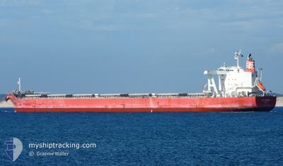
MG KRONOS
Cargo
Current Trip
MY PKG
| Time Travelled | 1 day |
|---|---|
| Remaining Time | --- |
| Distance Travelled | 3.01 морская миля |
| Remaining Distance | --- |
| AVG Speed | 3.8 Узлы |
| MAX Speed | 4.4 Узлы |
| AVG Wind | 5.1 knots |
| MAX Wind | 6.3 knots |
| MIN Temp | 27.6°C / 81.68°F |
| MAX Temp | 29°C / 84.2°F |
| Осадка | 12.3 м |
| Позиция Получена | 2 d тому назад |
Current Position
| Долгота | --- |
|---|---|
| Широта | --- |
| Статус | Under way using engine |
| Скорость | 10 Узлы |
| Курс | 295° |
| Район | Malacca Strait |
| Станция | T-AIS |
| Позиция Получена | 2 d тому назад |
Info
Information
The current position of MG KRONOS is in Malacca Strait with coordinates 1.73975° / 102.73691° as reported on 2025-03-01 03:14 by AIS to our vessel tracker app. The vessel's current speed is 10 Узлы
The vessel MG KRONOS (IMO: 9774288, MMSI: 371207000) is a Cargo It's sailing under the flag of [PA] Panama.
In this page you can find informations about the vessels current position, last detected port calls, and current voyage information. If the vessels is not in coverage by AIS you will find the latest position.
The current position of MG KRONOS is detected by our AIS receivers and we are not responsible for the reliability of the data. The last position was recorded while the vessel was in Coverage by the Ais receivers of our vessel tracking app.
The current draught of MG KRONOS as reported by AIS is 12.3 meters
Weather
| Temperature | 27.1°C / 80.78°F |
|---|---|
| Wind Speed | 3 knots |
| Direction | 47° NE |
| Pressure | 1010.2 hPa |
| Humidity | 79.3 % |
| Cloud Coverage | 99 % |
Featured Company
Last Port Calls
| Port | Arrival | Departure | Time In Port |
|---|---|---|---|
| 2025-03-02 09:29 | 2025-03-02 10:45 | 1 h | |
| 2025-02-10 03:46 | 2025-02-11 12:35 | 1 d | |
| 2025-01-20 03:57 | 2025-01-22 14:56 | 2 d |
Most Visited Ports (Last year)
| Port | Arrivals | |
|---|---|---|
| 3 | ||
| 1 | ||
| 1 | ||
| 1 | ||
| 1 | ||
| 1 |
Events
| Время | Событие | Детали | Позиция / Направление | Информация |
|---|---|---|---|---|
| 2025-03-02 11:34 | Окончание движения | 6.8 nm, North of PORT KLANG |
3.10722 / 101.31072
MY PKG
|
Скорость: 0.2 kn Курс: 320° |
| 2025-03-02 10:45 | ПОРТ ОТПРАВЛЕНИЯ |
|
3.06693 / 101.33793
MY PKG
|
Скорость: 7.9 kn Курс: 332° |
| 2025-03-02 09:29 | Порт |
|
2.91456 / 101.27611
[MY] PORT KLANG
|
Скорость: 10.9 kn Курс: 36° |
| 2025-03-02 07:58 | Начало движения | 13.64 nm, South of PORT KLANG |
2.77564 / 101.29887
MY PKG
|
Скорость: 3.9 kn Курс: 138° |
| 2025-03-01 14:54 | Окончание движения | 13.44 nm, South of PORT KLANG |
2.77985 / 101.29569
MY PKG
|
Скорость: 0.3 kn Курс: 351° |
| 2025-03-01 03:20 | Статус изменился | Default Under way using engine |
1.74766 / 102.72066
MY PKG
|
Скорость: 10 kn Курс: 295° |
| 2025-03-01 03:14 | Вне покрытия |
1.73975 / 102.73691
Malacca Strait
MY PKG
|
Скорость: 10 kn Курс: 295° |
|
| 2025-03-01 02:54 | Статус изменился | Under way using engine Default |
1.71557 / 102.78817
MY PKG
|
Скорость: 10.5 kn Курс: 291° |
| 2025-03-01 02:47 | Статус изменился | Default Under way using engine |
1.70744 / 102.80864
MY PKG
|
Скорость: 10 kn Курс: 291° |
| 2025-03-01 00:15 | Статус изменился | Under way using engine Default |
1.44948 / 103.18668
MY PKG
|
Скорость: 12.2 kn Курс: 310° |