
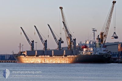
MED ISLAND
Bulk Carrier
Current Trip
| Time Travelled | 35 days |
|---|---|
| Remaining Time | --- |
| Distance Travelled | 3123.30 морская миля |
| Remaining Distance | --- |
| AVG Speed | 11.1 Узлы |
| MAX Speed | 11.1 Узлы |
| AVG Wind | 8.7 knots |
| MAX Wind | 23 knots |
| MIN Temp | 17.9°C / 64.22°F |
| MAX Temp | 29.3°C / 84.74°F |
| Осадка | 9.8 м |
| Позиция Получена | 1 m тому назад |
Current Position
| Долгота | --- |
|---|---|
| Широта | --- |
| Статус | Under way using engine |
| Скорость | 10.8 Узлы |
| Курс | 197.8° |
| Район | Aegean Sea |
| Станция | T-AIS |
| Позиция Получена | 1 m тому назад |
Info
Information
The current position of MED ISLAND is in Aegean Sea with coordinates 36.87004° / 23.99715° as reported on 2024-10-06 21:27 by AIS to our vessel tracker app. The vessel's current speed is 10.8 Узлы and is heading at the port of RADES. The estimated time of arrival as calculated by MyShipTracking vessel tracking app is 2024-10-09 15:00 LT
The vessel MED ISLAND (IMO: 9322748, MMSI: 256155000) is a Bulk Carrier that was built in 2005 ( 19 лет ). It's sailing under the flag of [MT] Malta.
In this page you can find informations about the vessels current position, last detected port calls, and current voyage information. If the vessels is not in coverage by AIS you will find the latest position.
The current position of MED ISLAND is detected by our AIS receivers and we are not responsible for the reliability of the data. The last position was recorded while the vessel was in Coverage by the Ais receivers of our vessel tracking app.
The current draught of MED ISLAND as reported by AIS is 9.8 meters
Weather
| Temperature | 23.6°C / 74.48°F |
|---|---|
| Wind Speed | 19 knots |
| Direction | 245° WSW |
| Pressure | 1011.3 hPa |
| Humidity | 68.8 % |
| Cloud Coverage | --- |
Featured Company
Events
| Время | Событие | Детали | Позиция / Направление | Информация |
|---|---|---|---|---|
| 2024-10-06 17:28 | Статус изменился | Under way using engine Default |
37.49229 / 24.34078
TN RDS
|
Скорость: 9.9 kn Курс: 218° |
| 2024-10-06 17:24 | Статус изменился | Default Under way using engine |
37.50282 / 24.35115
TN RDS
|
Скорость: 9.9 kn Курс: 217.3° |
| 2024-10-06 09:17 | Статус изменился | Under way using engine Default |
38.80914 / 25.11074
TN RDS
|
Скорость: 11.3 kn Курс: 208° |
| 2024-10-06 08:42 | Статус изменился | Default Under way using engine |
38.90889 / 25.17788
TN RDS
|
Скорость: 11.1 kn Курс: 207.6° |
| 2024-10-06 04:03 | Статус изменился | Under way using engine Default |
39.65145 / 25.66426
TN RDS
|
Скорость: 10.5 kn Курс: 206° |
| 2024-10-06 03:46 | Статус изменился | Default Under way using engine |
39.69770 / 25.69399
TN RDS
|
Скорость: 10.8 kn Курс: 206.6° |
| 2024-10-06 03:02 | Статус изменился | Under way using engine Default |
39.81948 / 25.77547
TN RDS
|
Скорость: 11.2 kn Курс: 207° |
| 2024-10-06 02:37 | Статус изменился | Default Under way using engine |
39.88627 / 25.82175
TN RDS
|
Скорость: 11 kn Курс: 226.8° |
| 2024-10-06 02:29 | Обнаружено в море | Greek part of the Aegean Sea |
39.90737 / 25.83954
Aegean Sea
TN RDS
|
Скорость: 11 kn Курс: 226.8° |
| 2024-10-06 02:00 | Статус изменился | Under way using engine Default |
39.96594 / 25.92809
TN RDS
|
Скорость: 11.1 kn Курс: 229° |