
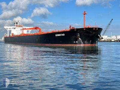
GRIMSTAD
Crude Oil Tanker
Current Trip
| Time Travelled | 9 days |
|---|---|
| Remaining Time | --- |
| Distance Travelled | 1158.04 морская миля |
| Remaining Distance | --- |
| AVG Speed | 9.7 Узлы |
| MAX Speed | 13.4 Узлы |
| AVG Wind | 10.1 knots |
| MAX Wind | 20 knots |
| MIN Temp | 6.2°C / 43.16°F |
| MAX Temp | 24.5°C / 76.1°F |
| Осадка | 9 м |
| Позиция Получена | 6 d тому назад |
Current Position
| Долгота | -70.58210° |
|---|---|
| Широта | 40.40745° |
| Статус | Under way using engine |
| Скорость | 13.3 Узлы |
| Курс | 92.2° |
| Район | North Atlantic Ocean |
| Станция | T-AIS |
| Позиция Получена | 6 d тому назад |
Info
Information
The current position of GRIMSTAD is in North Atlantic Ocean with coordinates 40.40745° / -70.58210° as reported on 2024-06-02 01:45 by AIS to our vessel tracker app. The vessel's current speed is 13.3 Узлы
The vessel GRIMSTAD (IMO: 9336402, MMSI: 309518000) is a Crude Oil Tanker that was built in 2007 ( 17 лет ). It's sailing under the flag of [BS] Bahamas.
In this page you can find informations about the vessels current position, last detected port calls, and current voyage information. If the vessels is not in coverage by AIS you will find the latest position.
The current position of GRIMSTAD is detected by our AIS receivers and we are not responsible for the reliability of the data. The last position was recorded while the vessel was in Coverage by the Ais receivers of our vessel tracking app.
The current draught of GRIMSTAD as reported by AIS is 9 meters
Weather
| Temperature | 10.3°C / 50.54°F |
|---|---|
| Wind Speed | 6 knots |
| Direction | 179° S |
| Pressure | 1004 hPa |
| Humidity | 86.9 % |
| Cloud Coverage | 100 % |
Featured Company
Last Port Calls
| Port | Arrival | Departure | Time In Port |
|---|---|---|---|
| 2024-05-29 15:50 | 2024-05-30 13:31 | 21 h | |
| 2024-04-28 12:03 | 2024-04-30 02:01 | 1 d | |
| 2024-04-08 08:53 | 2024-04-09 16:48 | 1 d | |
| 2024-04-01 01:04 |
Most Visited Ports (Last year)
| Port | Arrivals | |
|---|---|---|
| 4 | ||
| 2 | ||
| 2 | ||
| 2 | ||
| 1 | ||
| 1 |
Last Trips
| Origin | Departure | Destination | Arrival | Distance | |
|---|---|---|---|---|---|
| 2024-04-30 02:01 | 2024-05-29 15:50 | 5572.29 морская миля | |||
| 2024-04-09 16:48 | 2024-04-28 12:03 | 1735.10 морская миля | |||
| 2024-04-01 01:04 | 2024-04-08 08:53 | 334.61 морская миля |
Events
| Время | Событие | Детали | Позиция / Направление | Информация |
|---|---|---|---|---|
| 2024-06-05 17:38 | Окончание движения | 1.97 nm, South West of ARNOLD'S COVE |
47.73167 / -54.01500
CAWHH
|
Скорость: Курс: -1° |
| 2024-06-02 01:50 | Статус изменился | Default Under way using engine |
40.40667 / -70.55666
CAWHH
|
Скорость: 13.3 kn Курс: 92.2° |
| 2024-06-02 01:45 | Статус изменился | Under way using engine Default |
40.40745 / -70.58210
CAWHH
|
Скорость: 13.1 kn Курс: 88° |
| 2024-06-02 01:45 | Вне покрытия |
40.40745 / -70.58210
North Atlantic Ocean
CAWHH
|
Скорость: 13.3 kn Курс: 92.2° |
|
| 2024-06-02 01:28 | В покрытии |
40.40745 / -70.58210
North Atlantic Ocean
CAWHH
|
Скорость: 13.3 kn Курс: 92.2° |
|
| 2024-06-01 17:23 | Статус изменился | Default Under way using engine |
40.37500 / -72.95333
CAWHH
|
Скорость: 12.2 kn Курс: 89.7° |
| 2024-06-01 17:17 | Вне покрытия |
40.37531 / -72.98069
North Atlantic Ocean
CAWHH
|
Скорость: 12.2 kn Курс: 89.7° |
|
| 2024-06-01 10:35 | Начало движения | 6.18 nm, North of PERTH AMBOY |
40.63078 / -74.20221
CAWHH
|
Скорость: 3.1 kn Курс: 190° |
| 2024-06-01 10:28 | Статус изменился | Under way using engine Moored |
40.63302 / -74.20223
CAWHH
|
Скорость: Курс: 200° |
| 2024-06-01 10:22 | ETA изменился | 2024/06/05 12:00 2024/06/05 09:00 |
40.63300 / -74.20226
CAWHH
|
Скорость: Курс: 200° |