
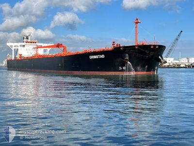
GRIMSTAD
Crude Oil Tanker
Current Trip
| Time Travelled | 15 days |
|---|---|
| Remaining Time | 1 day |
| Distance Travelled | 2027.34 nm |
| Remaining Distance | 296.30 nm |
| AVG Speed | 10.7 Noeuds |
| MAX Speed | 13.3 Noeuds |
| AVG Wind | 12.3 knots |
| MAX Wind | 29.8 knots |
| MIN Temp | 13°C / 55.4°F |
| MAX Temp | 22.5°C / 72.5°F |
| Tirant d eau | 12.6 m |
| Position reçue | 1 d depuis |
Current Position
| Longitude | 8.49869° |
|---|---|
| Latitude | 37.64814° |
| Etat | Under way using engine |
| Vitesse | 11.8 Noeuds |
| Parcours | 260.3° |
| Zone | Mediterranean Sea - Western Basin |
| Station | T-AIS |
| Position reçue | 1 d depuis |
Info
Information
The current position of GRIMSTAD is in Mediterranean Sea - Western Basin with coordinates 37.64814° / 8.49869° as reported on 2024-05-13 20:35 by AIS to our vessel tracker app. The vessel's current speed is 11.8 Noeuds and is heading at the port of GIBRALTAR. The estimated time of arrival as calculated by MyShipTracking vessel tracking app is 2024-05-16 11:14 LT
The vessel GRIMSTAD (IMO: 9336402, MMSI: 309518000) is a Crude Oil Tanker that was built in 2007 ( 17 Age ). It's sailing under the flag of [BS] Bahamas.
In this page you can find informations about the vessels current position, last detected port calls, and current voyage information. If the vessels is not in coverage by AIS you will find the latest position.
The current position of GRIMSTAD is detected by our AIS receivers and we are not responsible for the reliability of the data. The last position was recorded while the vessel was in Coverage by the Ais receivers of our vessel tracking app.
The current draught of GRIMSTAD as reported by AIS is 12.6 meters
Weather
| Temperature | 17.9°C / 64.22°F |
|---|---|
| Wind Speed | 21 knots |
| Direction | 243° WSW |
| Pressure | 1007.3 hPa |
| Humidity | 87 % |
| Cloud Coverage | 22 % |
Featured Company
Last Port Calls
| Port | Arrival | Departure | Time In Port |
|---|---|---|---|
| 2024-04-28 09:03 | 2024-04-29 23:01 | 1 d | |
| 2024-04-08 06:53 | 2024-04-09 14:48 | 1 d | |
| 2024-03-30 11:46 | 2024-04-01 00:04 | 1 d | |
| 2024-03-16 19:37 | 2024-03-19 01:58 | 2 d |
Most Visited Ports (Last year)
| Port | Arrivals | |
|---|---|---|
| 4 | ||
| 2 | ||
| 2 | ||
| 1 | ||
| 1 | ||
| 1 |
Last Trips
Events
| Heure | Evenement | Détails | Position/ Destination | Info |
|---|---|---|---|---|
| 2024-05-13 20:39 | Etat Changé | Default Under way using engine |
37.64669 / 8.48082
GI GIB
|
Vitesse: 11.8 kn Parcours: 260.3° |
| 2024-05-13 20:35 | Hors de la zone couverte |
37.64814 / 8.49869
Mediterranean Sea - Western Basin
GI GIB
|
Vitesse: 11.8 kn Parcours: 260.3° |
|
| 2024-05-13 20:34 | Changement de zone | Tunisian part of the Mediterranean Sea - Western Basin Tunisian part of the Mediterranean Sea - Eastern Basin |
37.64867 / 8.50276
Mediterranean Sea - Western Basin
GI GIB
|
Vitesse: 11.8 kn Parcours: 261.2° |
| 2024-05-13 20:34 | Etat Changé | Under way using engine Default |
37.64867 / 8.50276
GI GIB
|
Vitesse: 11.7 kn Parcours: 262° |
| 2024-05-13 20:22 | Dans la zone couverte |
37.64867 / 8.50276
Mediterranean Sea - Western Basin
GI GIB
|
Vitesse: 11.8 kn Parcours: 261.2° |
|
| 2024-05-13 06:55 | Etat Changé | Default Under way using engine |
37.16333 / 11.79500
GI GIB
|
Vitesse: 11.8 kn Parcours: 300.6° |
| 2024-05-13 06:52 | Changement de zone | Tunisian part of the Mediterranean Sea - Eastern Basin Italian part of the Mediterranean Sea - Eastern Basin |
37.15945 / 11.80712
Mediterranean Sea - Eastern Basin
GI GIB
|
Vitesse: 11.8 kn Parcours: 300.6° |
| 2024-05-13 06:52 | Etat Changé | Under way using engine Default |
37.15945 / 11.80712
GI GIB
|
Vitesse: 11 kn Parcours: 302° |
| 2024-05-13 06:52 | Hors de la zone couverte |
37.15945 / 11.80712
Mediterranean Sea - Eastern Basin
GI GIB
|
Vitesse: 11.8 kn Parcours: 300.6° |
|
| 2024-05-13 05:50 | Hors de la zone couverte |
37.05060 / 12.02455
Mediterranean Sea - Eastern Basin
GI GIB
|
Vitesse: 11.7 kn Parcours: 301.7° |