
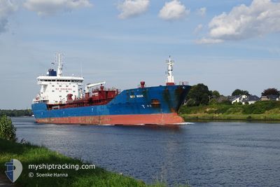
BRO NUUK
Oil/Chemical Tanker
Current Trip
| Time Travelled | 17 h, 40 mins |
|---|---|
| Remaining Time | 1 day |
| Distance Travelled | 158.85 морская миля |
| Remaining Distance | 499.48 морская миля |
| AVG Speed | 11.4 Узлы |
| MAX Speed | 13.4 Узлы |
| AVG Wind | 7.5 knots |
| MAX Wind | 18.2 knots |
| MIN Temp | 9.3°C / 48.74°F |
| MAX Temp | 11°C / 51.8°F |
| Осадка | 6.4 м |
| Позиция Получена | 4 h, 10 m тому назад |
Current Position
| Долгота | -5.68419° |
|---|---|
| Широта | 52.20552° |
| Статус | Under way using engine |
| Скорость | 11.6 Узлы |
| Курс | 199.7° |
| Район | Irish Sea and St. George's Channel |
| Станция | T-AIS |
| Позиция Получена | 4 h, 10 m тому назад |
Info
Information
The current position of BRO NUUK is in Irish Sea and St. George's Channel with coordinates 52.20552° / -5.68419° as reported on 2024-05-02 18:09 by AIS to our vessel tracker app. The vessel's current speed is 11.6 Узлы and is heading at the port of ANTWERP. The estimated time of arrival as calculated by MyShipTracking vessel tracking app is 2024-05-04 16:32 LT
The vessel BRO NUUK (IMO: 9323819, MMSI: 220502000) is a Oil/Chemical Tanker that was built in 2008 ( 16 лет ). It's sailing under the flag of [DK] Denmark.
In this page you can find informations about the vessels current position, last detected port calls, and current voyage information. If the vessels is not in coverage by AIS you will find the latest position.
The current position of BRO NUUK is detected by our AIS receivers and we are not responsible for the reliability of the data. The last position was recorded while the vessel was in Coverage by the Ais receivers of our vessel tracking app.
The current draught of BRO NUUK as reported by AIS is 6.4 meters
Weather
| Temperature | 10.5°C / 50.9°F |
|---|---|
| Wind Speed | 17 knots |
| Direction | 263° W |
| Pressure | 1007.7 hPa |
| Humidity | 82.1 % |
| Cloud Coverage | 95 % |
Featured Company
Last Port Calls
| Port | Arrival | Departure | Time In Port |
|---|---|---|---|
| 2024-05-02 03:47 | 2024-05-02 04:40 | 52 m | |
| 2024-04-30 04:38 | 2024-05-02 02:56 | 1 d | |
| 2024-04-30 03:20 | 2024-04-30 04:10 | 49 m | |
| 2024-04-26 17:35 | 2024-04-30 00:26 | 3 d | |
| 2024-04-24 21:04 | 2024-04-26 08:30 | 1 d | |
| 2024-04-21 00:02 | 2024-04-22 11:43 | 1 d | |
| 2024-03-22 21:13 | 2024-03-28 15:29 | 5 d | |
| 2024-03-09 21:07 | 2024-03-10 10:09 | 13 h | |
| 2024-03-01 11:48 | 2024-03-02 20:31 | 1 d | |
| 2024-03-01 10:43 |
Last Trips
| Origin | Departure | Destination | Arrival | Distance | |
|---|---|---|---|---|---|
| 2024-05-02 03:56 | 2024-05-02 04:47 | 1.89 морская миля | |||
| 2024-04-30 05:10 | 2024-04-30 05:38 | 1.69 морская миля | |||
| 2024-04-26 09:30 | 2024-04-30 04:20 | 134.72 морская миля | |||
| 2024-04-26 09:30 | 2024-04-26 18:35 | 101.48 морская миля | |||
| 2024-04-22 13:43 | 2024-04-24 22:04 | 641.56 морская миля | |||
| 2024-03-28 16:29 | 2024-04-21 02:02 | 4641.08 морская миля | |||
| 2024-03-10 10:09 | 2024-03-22 22:13 | 2697.43 морская миля | |||
| 2024-03-02 21:31 | 2024-03-09 21:07 | 1780.28 морская миля | |||
| 2024-03-01 11:43 | 2024-03-01 12:48 | 5.80 морская миля |
Events
| Время | Событие | Детали | Позиция / Направление | Информация |
|---|---|---|---|---|
| 2024-05-02 18:16 | Статус изменился | Default Under way using engine |
52.18405 / -5.69669
BE ANR
|
Скорость: 11.6 kn Курс: 199.7° |
| 2024-05-02 18:09 | Вне покрытия |
52.20552 / -5.68419
Irish Sea and St. George's Channel
BE ANR
|
Скорость: 11.6 kn Курс: 199.7° |
|
| 2024-05-02 17:48 | Изменение морского района | United Kingdom part of the Irish Sea and St. George's Channel Irish part of the Irish Sea and St. George's Channel |
52.26819 / -5.64816
Irish Sea and St. George's Channel
BE ANR
|
Скорость: 11.4 kn Курс: 198.6° |
| 2024-05-02 17:48 | Статус изменился | Under way using engine Default |
52.26819 / -5.64816
BE ANR
|
Скорость: 11.4 kn Курс: 199° |
| 2024-05-02 17:33 | Статус изменился | Default Under way using engine |
52.31366 / -5.62253
BE ANR
|
Скорость: 11.2 kn Курс: 198.6° |
| 2024-05-02 17:12 | Обнаружено в море | Irish part of the Irish Sea and St. George's Channel |
52.37721 / -5.58672
Irish Sea and St. George's Channel
BE ANR
|
Скорость: 10.8 kn Курс: 200° |
| 2024-05-02 17:12 | Статус изменился | Under way using engine Default |
52.37721 / -5.58672
BE ANR
|
Скорость: 10.8 kn Курс: 199° |
| 2024-05-02 16:55 | В покрытии |
52.37721 / -5.58672
Irish Sea and St. George's Channel
BE ANR
|
Скорость: 10.8 kn Курс: 200° |
|
| 2024-05-02 14:47 | Статус изменился | Default Under way using engine |
52.77948 / -5.35614
BE ANR
|
Скорость: 10.3 kn Курс: 200.9° |
| 2024-05-02 14:41 | Вне покрытия |
52.79424 / -5.34686
Irish Sea and St. George's Channel
BE ANR
|
Скорость: 10.3 kn Курс: 200.9° |