

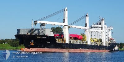
BBC RAISE
General Cargo

Current Trip
| Trip Time | 5 days |
|---|---|
| Trip Distance | 1813.66 морская миля |
| AVG Speed | 13.9 Узлы |
| MAX Speed | 16.2 Узлы |
| Осадка | 6.2 м |
| AVG Wind | 13.6 knots |
| MAX Wind | 34.8 knots |
| MIN Temp | 5.4°C / 41.72°F |
| MAX Temp | 15.8°C / 60.44°F |
| Позиция Получена | 2 m тому назад |
Current Position
| Долгота | --- |
|---|---|
| Широта | --- |
| Статус | Moored |
| Скорость | |
| Курс | 286° |
| Район | North Atlantic Ocean |
| Станция | T-AIS |
| Позиция Получена | 2 m тому назад |
Information
The current position of BBC RAISE is in North Atlantic Ocean with coordinates 36.51874° / -6.25115° as reported on 2025-03-28 04:05 by AIS to our vessel tracker app. The vessel's current speed is 0 Узлы and is currently inside the port of CADIZ.
The vessel BBC RAISE (IMO: 9538880, MMSI: 304439000) is a General Cargo that was built in 2011 ( 14 лет ). It's sailing under the flag of [AG] Antigua Barbuda.
In this page you can find informations about the vessels current position, last detected port calls, and current voyage information. If the vessels is not in coverage by AIS you will find the latest position.
The current position of BBC RAISE is detected by our AIS receivers and we are not responsible for the reliability of the data. The last position was recorded while the vessel was in Coverage by the Ais receivers of our vessel tracking app.
The current draught of BBC RAISE as reported by AIS is 6.2 meters
Weather
| Temperature | 11°C / 51.8°F |
|---|---|
| Wind Speed | 4 knots |
| Direction | 43° NE |
| Pressure | 1016.3 hPa |
| Humidity | 83 % |
| Cloud Coverage | --- |


Featured Company
Last Port Calls
| Port | Arrival | Departure | Time In Port |
|---|---|---|---|
| 2025-03-27 06:55 | |||
| 2025-03-20 13:23 | 2025-03-21 20:20 | 1 d | |
| 2025-03-13 04:53 | 2025-03-19 07:31 | 6 d | |
| 2025-03-08 10:58 | 2025-03-11 22:17 | 3 d | |
| 2025-03-07 06:00 | 2025-03-07 18:30 | 12 h | |
| 2025-03-06 12:11 | 2025-03-06 19:20 | 7 h | |
| 2025-03-04 00:26 | 2025-03-05 14:30 | 1 d | |
| 2025-01-26 17:10 | 2025-01-28 15:15 | 1 d | |
| 2025-01-09 06:17 | 2025-01-09 18:33 | 12 h |
Last Trips
| Origin | Departure | Destination | Arrival | Distance | |
|---|---|---|---|---|---|
| 2025-03-21 20:20 | 2025-03-27 06:55 | 1813.66 морская миля | |||
| 2025-03-19 07:31 | 2025-03-20 13:23 | 421.24 морская миля | |||
| 2025-03-11 22:17 | 2025-03-13 04:53 | 300.79 морская миля | |||
| 2025-03-07 18:30 | 2025-03-08 10:58 | 206.11 морская миля | |||
| 2025-03-06 19:20 | 2025-03-07 06:00 | 144.39 морская миля | |||
| 2025-03-05 14:30 | 2025-03-06 12:11 | 155.10 морская миля | |||
| 2025-01-28 15:15 | 2025-03-04 00:26 | 10110.04 морская миля | |||
| 2025-01-09 18:33 | 2025-01-26 17:10 | 3499.83 морская миля | |||
| 2024-12-26 00:48 | 2025-01-09 06:17 | 1520.62 морская миля |
Events
| Время | Событие | Детали | Позиция / Направление | Информация |
|---|---|---|---|---|
| 2025-03-28 00:41 | Статус изменился | Moored Default |
36.51882 / -6.25129
[ES] CADIZ
|
Скорость: Курс: 286° |
| 2025-03-28 00:38 | Статус изменился | Default Moored |
36.51883 / -6.25117
[ES] CADIZ
|
Скорость: Курс: 286° |
| 2025-03-27 06:38 | Статус изменился | Moored Under way using engine |
36.51871 / -6.25117
[ES] CADIZ
|
Скорость: Курс: 286° |
| 2025-03-27 06:29 | Окончание движения |
36.51883 / -6.25167
[ES] CADIZ
|
Скорость: 0.3 kn Курс: 277° |
|
| 2025-03-27 05:55 | Порт |
|
36.53828 / -6.26826
[ES] CADIZ
|
Скорость: 5.1 kn Курс: 152.9° |
| 2025-03-27 03:02 | Статус изменился | Under way using engine Default |
36.51783 / -6.77033
ESCAD
|
Скорость: 13.7 kn Курс: 89° |
| 2025-03-27 02:49 | В покрытии |
36.51800 / -6.76800
North Atlantic Ocean
ESCAD
|
Скорость: 13.3 kn Курс: 88° |
|
| 2025-03-27 01:32 | Статус изменился | Default Under way using engine |
36.51017 / -7.19350
ESCAD
|
Скорость: 13.7 kn Курс: 88° |
| 2025-03-27 01:25 | Вне покрытия |
36.50917 / -7.22417
North Atlantic Ocean
ESCAD
|
Скорость: 13.7 kn Курс: 88° |
|
| 2025-03-27 01:21 | Статус изменился | Under way using engine Default |
36.50867 / -7.24150
ESCAD
|
Скорость: 13.9 kn Курс: 88° |