
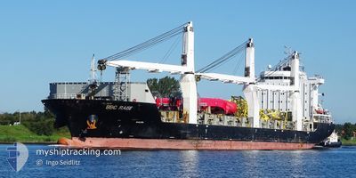
BBC RAISE
General Cargo
Current Trip
| Time Travelled | 8 days |
|---|---|
| Remaining Time | --- |
| Distance Travelled | 2210.55 nm |
| Remaining Distance | --- |
| AVG Speed | 14.6 Noeuds |
| MAX Speed | 18 Noeuds |
| AVG Wind | 12.7 knots |
| MAX Wind | 27.8 knots |
| MIN Temp | 17.9°C / 64.22°F |
| MAX Temp | 26.3°C / 79.34°F |
| Tirant d eau | 7.5 m |
| Position reçue | 8 d depuis |
Current Position
| Longitude | -97.42900° |
|---|---|
| Latitude | 22.54517° |
| Etat | Under way using engine |
| Vitesse | 15.1 Noeuds |
| Parcours | 83° |
| Zone | Gulf of Mexico |
| Station | T-AIS |
| Position reçue | 8 d depuis |
Info
Information
The current position of BBC RAISE is in Gulf of Mexico with coordinates 22.54517° / -97.42900° as reported on 2024-04-26 08:48 by AIS to our vessel tracker app. The vessel's current speed is 15.1 Noeuds and is heading at the port of MOREHEAD CITY. The estimated time of arrival as calculated by MyShipTracking vessel tracking app is 2024-04-30 20:00 LT
The vessel BBC RAISE (IMO: 9538880, MMSI: 304439000) is a General Cargo that was built in 2011 ( 13 Age ). It's sailing under the flag of [AG] Antigua Barbuda.
In this page you can find informations about the vessels current position, last detected port calls, and current voyage information. If the vessels is not in coverage by AIS you will find the latest position.
The current position of BBC RAISE is detected by our AIS receivers and we are not responsible for the reliability of the data. The last position was recorded while the vessel was in Coverage by the Ais receivers of our vessel tracking app.
The current draught of BBC RAISE as reported by AIS is 7.5 meters
Weather
| Temperature | 17.9°C / 64.22°F |
|---|---|
| Wind Speed | 15 knots |
| Direction | 20° NNE |
| Pressure | 1018.5 hPa |
| Humidity | 69.8 % |
| Cloud Coverage | 100 % |
Featured Company
Last Port Calls
| Port | Arrival | Departure | Time In Port |
|---|---|---|---|
| 2024-04-24 21:38 | 2024-04-26 07:02 | 1 d | |
| 2024-04-23 18:15 | 2024-04-24 12:34 | 18 h | |
| 2024-04-20 10:04 | 2024-04-22 05:45 | 1 d | |
| 2024-04-16 02:41 | 2024-04-17 21:11 | 1 d | |
| 2024-04-13 12:23 | 2024-04-15 03:16 | 1 d | |
| 2024-04-01 20:33 | 2024-04-02 22:37 | 1 d | |
| 2024-03-30 22:31 | 2024-03-31 20:00 | 21 h | |
| 2024-03-24 18:23 | 2024-03-25 01:58 | 7 h | |
| 2024-03-18 09:39 | 2024-03-22 08:09 | 3 d | |
| 2024-03-08 15:48 | 2024-03-09 04:32 | 12 h |
Most Visited Ports (Last year)
| Port | Arrivals | |
|---|---|---|
| 8 | ||
| 4 | ||
| 4 | ||
| 3 | ||
| 2 | ||
| 2 |
Last Trips
| Origin | Departure | Destination | Arrival | Distance | |
|---|---|---|---|---|---|
| 2024-04-24 07:34 | 2024-04-24 16:38 | 37.33 nm | |||
| 2024-04-22 00:45 | 2024-04-23 13:15 | 498.57 nm | |||
| 2024-04-17 16:11 | 2024-04-20 05:04 | 441.59 nm | |||
| 2024-04-14 22:16 | 2024-04-15 21:41 | 336.61 nm | |||
| 2024-04-02 17:37 | 2024-04-13 07:23 | 3363.61 nm | |||
| 2024-03-31 17:00 | 2024-04-01 15:33 | 380.18 nm | |||
| 2024-03-24 22:58 | 2024-03-30 19:31 | 594.81 nm | |||
| 2024-03-22 05:09 | 2024-03-24 15:23 | 642.13 nm | |||
| 2024-03-08 23:32 | 2024-03-18 06:39 | 666.64 nm | |||
| 2024-03-08 05:36 | 2024-03-08 10:48 | 62.68 nm |
Events
| Heure | Evenement | Détails | Position/ Destination | Info |
|---|---|---|---|---|
| 2024-05-02 22:13 | Démarrage | 3.18 nm, South of FORT MACON |
34.64633 / -76.66950
USMRH
|
Vitesse: 4.6 kn Parcours: 181° |
| 2024-04-30 21:10 | Arret | 3.09 nm, South of FORT MACON |
34.64834 / -76.66666
USMRH
|
Vitesse: Parcours: -1° |
| 2024-04-26 08:52 | Etat Changé | Default Under way using engine |
22.54667 / -97.41167
USMRH
|
Vitesse: 15.1 kn Parcours: 83° |
| 2024-04-26 08:48 | Hors de la zone couverte |
22.54517 / -97.42900
Gulf of Mexico
USMRH
|
Vitesse: 15.1 kn Parcours: 83° |
|
| 2024-04-26 07:43 | Changement d'ETA | 2024/04/30 20:00 2024/04/30 17:00 |
22.50650 / -97.71883
USMRH
|
Vitesse: 14.7 kn Parcours: 81° |
| 2024-04-26 07:02 | PORT DE DEPART |
|
22.48717 / -97.85683
USMRH
|
Vitesse: 6.1 kn Parcours: 89° |
| 2024-04-26 06:58 | Démarrage |
22.48717 / -97.86467
[MX] ALTAMIRA
|
Vitesse: 3.2 kn Parcours: 90° |
|
| 2024-04-26 06:46 | Etat Changé | Under way using engine Moored |
22.48517 / -97.86567
[MX] ALTAMIRA
|
Vitesse: Parcours: 89° |
| 2024-04-26 05:53 | Changement de destination | USMRH MXATM |
22.48517 / -97.86567
[MX] ALTAMIRA
|
Vitesse: Parcours: 89° |
| 2024-04-26 05:46 | Changement d'ETA | 2024/04/30 17:00 2024/04/23 14:00 |
22.48517 / -97.86567
[MX] ALTAMIRA
|
Vitesse: Parcours: 89° |