
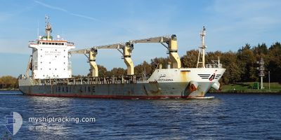
AL-MOTHANNA
Cargo
Current Trip
| Time Travelled | 4 days |
|---|---|
| Remaining Time | --- |
| Distance Travelled | 1408.89 морская миля |
| Remaining Distance | --- |
| AVG Speed | 12.8 Узлы |
| MAX Speed | 14.1 Узлы |
| AVG Wind | 9.6 knots |
| MAX Wind | 19 knots |
| MIN Temp | 26°C / 78.8°F |
| MAX Temp | 30°C / 86°F |
| Осадка | 7.9 м |
| Позиция Получена | 13 h, 35 m тому назад |
Current Position
| Долгота | 77.42586° |
|---|---|
| Широта | 7.59935° |
| Статус | Under way using engine |
| Скорость | 12.8 Узлы |
| Курс | 129.2° |
| Район | Laccadive Sea |
| Станция | T-AIS |
| Позиция Получена | 13 h, 35 m тому назад |
Info
Information
The current position of AL-MOTHANNA is in Laccadive Sea with coordinates 7.59935° / 77.42586° as reported on 2024-04-26 14:41 by AIS to our vessel tracker app. The vessel's current speed is 12.8 Узлы and is heading at the port of KUPANG. The estimated time of arrival as calculated by MyShipTracking vessel tracking app is 2024-05-08 11:30 LT
The vessel AL-MOTHANNA (IMO: 9649976, MMSI: 438031044) is a Cargo It's sailing under the flag of [JO] Jordan.
In this page you can find informations about the vessels current position, last detected port calls, and current voyage information. If the vessels is not in coverage by AIS you will find the latest position.
The current position of AL-MOTHANNA is detected by our AIS receivers and we are not responsible for the reliability of the data. The last position was recorded while the vessel was in Coverage by the Ais receivers of our vessel tracking app.
The current draught of AL-MOTHANNA as reported by AIS is 7.9 meters
Weather
| Temperature | 29.3°C / 84.74°F |
|---|---|
| Wind Speed | 5 knots |
| Direction | 71° ENE |
| Pressure | 1009 hPa |
| Humidity | 75.6 % |
| Cloud Coverage | 100 % |
Featured Company
Last Port Calls
| Port | Arrival | Departure | Time In Port |
|---|---|---|---|
| 2024-04-18 05:13 | 2024-04-22 06:10 | 4 d | |
| 2024-03-19 13:24 | 2024-03-27 14:59 | 8 d | |
| 2024-03-13 05:49 |
Last Trips
| Origin | Departure | Destination | Arrival | Distance | |
|---|---|---|---|---|---|
| 2024-03-27 18:59 | 2024-04-18 10:13 | 1205.60 морская миля | |||
| 2024-03-13 09:49 | 2024-03-19 17:24 | 31.08 морская миля |
Events
| Время | Событие | Детали | Позиция / Направление | Информация |
|---|---|---|---|---|
| 2024-04-26 14:54 | Статус изменился | Default Under way using engine |
7.57020 / 77.46221
TENAU KUPANG
|
Скорость: 12.8 kn Курс: 129.2° |
| 2024-04-26 14:41 | Статус изменился | Under way using engine Default |
7.59935 / 77.42586
TENAU KUPANG
|
Скорость: 11.8 kn Курс: 131° |
| 2024-04-26 14:41 | Вне покрытия |
7.59935 / 77.42586
Laccadive Sea
TENAU KUPANG
|
Скорость: 12.8 kn Курс: 129.2° |
|
| 2024-04-26 14:23 | Статус изменился | Default Under way using engine |
7.64066 / 77.37634
TENAU KUPANG
|
Скорость: 12.2 kn Курс: 134.6° |
| 2024-04-26 10:38 | Осадка изменилась | 7.9 5.8 |
8.13729 / 76.75420
TENAU KUPANG
|
Скорость: 12.6 kn Курс: 127.5° |
| 2024-04-26 10:38 | Пункт назначения изменился | TENAU KUPANG PORT QASIM |
8.13729 / 76.75420
TENAU KUPANG
|
Скорость: 12.6 kn Курс: 127.5° |
| 2024-04-26 10:38 | ETA изменился | 2024/05/08 11:30 2024/04/18 14:00 |
8.13729 / 76.75420
TENAU KUPANG
|
Скорость: 12.6 kn Курс: 127.5° |
| 2024-04-26 09:27 | Обнаружено в море | Indian part of the Laccadive Sea |
8.29267 / 76.56590
Laccadive Sea
|
Скорость: 12.3 kn Курс: 126.1° |
| 2024-04-26 09:27 | Статус изменился | Under way using engine Default |
8.29267 / 76.56590
PORT QASIM
|
Скорость: 12.3 kn Курс: 122° |
| 2024-04-26 09:08 | В покрытии |
8.29267 / 76.56590
Laccadive Sea
|
Скорость: 12.3 kn Курс: 126.1° |