
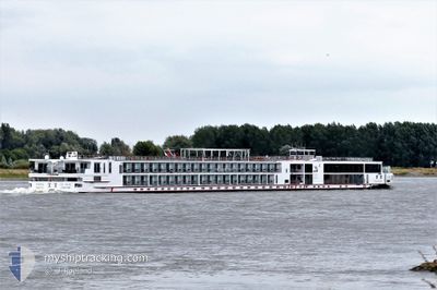
VIKING BESTLA
Passenger
Current Trip
| Trip Time | 4 days |
|---|---|
| Trip Distance | 255.41 nm |
| AVG Speed | 6.1 Knopen |
| MAX Speed | 10.1 Knopen |
| Diepgang | 1.8 M |
| AVG Wind | 4.9 knots |
| MAX Wind | 10.2 knots |
| MIN Temp | 1.9°C / 35.42°F |
| MAX Temp | 9.8°C / 49.64°F |
| Positie ontvangen | 3 m geleden |
Current Position
| Lengtegraad | 7.58812° |
|---|---|
| Breedtegraat | 47.58648° |
| Status | Moored |
| Snelheid | |
| Koers | 200° |
| Gebied | North Sea |
| Station | T-AIS |
| Positie ontvangen | 3 m geleden |
Info
Information
The current position of VIKING BESTLA is in North Sea with coordinates 47.58648° / 7.58812° as reported on 2024-04-28 08:36 by AIS to our vessel tracker app. The vessel's current speed is 0 Knopen and is currently inside the port of WEIL AM RHEIN.
The vessel VIKING BESTLA (IMO: 7001988, MMSI: 269057467) is a Passenger It's sailing under the flag of [CH] Switzerland.
In this page you can find informations about the vessels current position, last detected port calls, and current voyage information. If the vessels is not in coverage by AIS you will find the latest position.
The current position of VIKING BESTLA is detected by our AIS receivers and we are not responsible for the reliability of the data. The last position was recorded while the vessel was in Coverage by the Ais receivers of our vessel tracking app.
The current draught of VIKING BESTLA as reported by AIS is 1.8 meters
Weather
| Temperature | 12.4°C / 54.32°F |
|---|---|
| Wind Speed | 3 knots |
| Direction | 68° ENE |
| Pressure | 1012.1 hPa |
| Humidity | 63.1 % |
| Cloud Coverage | 100 % |
Featured Company
Last Port Calls
| Port | Arrival | Departure | Time In Port |
|---|---|---|---|
| 2024-04-28 03:21 | |||
| 2024-04-23 09:45 | 2024-04-23 21:34 | 11 h | |
| 2024-04-22 01:18 | 2024-04-22 01:42 | 23 m | |
| 2024-04-20 03:14 | 2024-04-21 22:36 | 1 d | |
| 2024-04-19 22:31 | 2024-04-19 22:59 | 27 m | |
| 2024-04-19 09:56 |
Most Visited Ports (Last year)
| Port | Arrivals | |
|---|---|---|
| 21 | ||
| 13 | ||
| 13 | ||
| 11 | ||
| 10 | ||
| 10 |
Last Trips
| Origin | Departure | Destination | Arrival | Distance | |
|---|---|---|---|---|---|
| 2024-04-23 23:34 | 2024-04-28 05:21 | 255.41 nm | |||
| 2024-04-22 03:42 | 2024-04-23 11:45 | 177.48 nm | |||
| 2024-04-22 00:36 | 2024-04-22 03:18 | 23.67 nm | |||
| 2024-04-20 00:59 | 2024-04-20 05:14 | 35.33 nm | |||
| 2024-04-19 11:56 | 2024-04-20 00:31 | 119.74 nm |
Events
| Tijd | Evenement | Details | Positie / Bestemming | Info |
|---|---|---|---|---|
| 2024-04-28 03:54 | Status Changed | Moored Under way using engine |
47.58648 / 7.58812
[DE] WEIL AM RHEIN
|
Snelheid: Koers: 200° |
| 2024-04-28 03:23 | Stop beweging |
47.58710 / 7.58842
[DE] WEIL AM RHEIN
|
Snelheid: 0.3 kn Koers: 200° |
|
| 2024-04-28 03:21 | Aankomsthaven |
|
47.58726 / 7.58851
[DE] WEIL AM RHEIN
|
Snelheid: 0.6 kn Koers: 200° |
| 2024-04-28 02:31 | Start beweging | 3.93 nm, North West of HUNINGUE |
47.64996 / 7.52958
BASEL
|
Snelheid: 3.8 kn Koers: 145° |
| 2024-04-28 01:49 | Stop beweging | 4.32 nm, North West of HUNINGUE |
47.65514 / 7.52363
BASEL
|
Snelheid: 0.3 kn Koers: 143° |
| 2024-04-28 00:38 | Start beweging | 10.24 nm, North of HUNINGUE |
47.76494 / 7.52751
BASEL
|
Snelheid: 3.3 kn Koers: 173° |
| 2024-04-28 00:22 | Stop beweging | 10.45 nm, North of HUNINGUE |
47.76842 / 7.52660
BASEL
|
Snelheid: Koers: 172° |
| 2024-04-27 23:26 | Binnenbereik |
47.81157 / 7.54136
North Sea
BASEL
|
Snelheid: 5.7 kn Koers: 196.8° |
|
| 2024-04-26 06:12 | Buitenbereik |
48.67365 / 7.90033
North Sea
BASEL
|
Snelheid: 9.4 kn Koers: 195.4° |
|
| 2024-04-26 06:12 | Binnenbereik |
48.67365 / 7.90033
North Sea
BASEL
|
Snelheid: 9.4 kn Koers: 195.4° |