
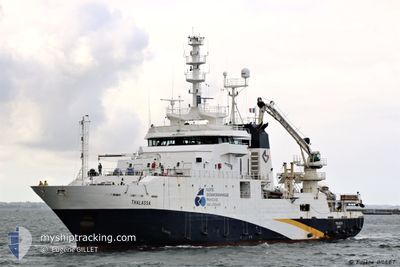
THALASSA
Fishery Research Vessel
Current Trip
| Time Travelled | 7 days |
|---|---|
| Remaining Time | 2 h, 38 mins |
| Distance Travelled | 855.56 nm |
| Remaining Distance | 60.04 nm |
| AVG Speed | 7.6 Knopen |
| MAX Speed | 14.4 Knopen |
| AVG Wind | 8.8 knots |
| MAX Wind | 23.5 knots |
| MIN Temp | 10°C / 50°F |
| MAX Temp | 19.3°C / 66.74°F |
| Diepgang | 6.1 M |
| Positie ontvangen | 4 h, 19 m geleden |
Current Position
| Lengtegraad | -1.37192° |
|---|---|
| Breedtegraat | 45.25310° |
| Status | Under way using engine |
| Snelheid | 9.8 Knopen |
| Koers | 261.8° |
| Gebied | Bay of Biscay |
| Station | T-AIS |
| Positie ontvangen | 4 h, 19 m geleden |
Info
Information
The current position of THALASSA is in Bay of Biscay with coordinates 45.25310° / -1.37192° as reported on 2024-05-05 13:47 by AIS to our vessel tracker app. The vessel's current speed is 9.8 Knopen and is heading at the port of LA PALLICE. The estimated time of arrival as calculated by MyShipTracking vessel tracking app is 2024-05-05 20:44 LT
The vessel THALASSA (IMO: 9070307, MMSI: 227297000) is a Fishery Research Vessel that was built in 1995 ( 29 Jaar oud ). It's sailing under the flag of [FR] France.
In this page you can find informations about the vessels current position, last detected port calls, and current voyage information. If the vessels is not in coverage by AIS you will find the latest position.
The current position of THALASSA is detected by our AIS receivers and we are not responsible for the reliability of the data. The last position was recorded while the vessel was in Coverage by the Ais receivers of our vessel tracking app.
The current draught of THALASSA as reported by AIS is 6.1 meters
Weather
| Temperature | 15.3°C / 59.54°F |
|---|---|
| Wind Speed | 16 knots |
| Direction | 255° WSW |
| Pressure | 1009.6 hPa |
| Humidity | 86.9 % |
| Cloud Coverage | 100 % |
Featured Company
Most Visited Ports (Last year)
| Port | Arrivals | |
|---|---|---|
| 13 | ||
| 3 | ||
| 3 | ||
| 1 | ||
| 1 | ||
| 1 |
Events
| Tijd | Evenement | Details | Positie / Bestemming | Info |
|---|---|---|---|---|
| 2024-05-05 13:47 | Buitenbereik |
45.25310 / -1.37192
Bay of Biscay
FR LPE
|
Snelheid: 9.8 kn Koers: 261.8° |
|
| 2024-05-05 13:32 | Binnenbereik |
45.25780 / -1.32377
Bay of Biscay
FR LPE
|
Snelheid: 8.8 kn Koers: 262° |
|
| 2024-05-05 11:43 | Buitenbereik |
45.25715 / -1.33021
Bay of Biscay
FR LPE
|
Snelheid: 9.7 kn Koers: 263° |
|
| 2024-05-05 10:02 | Status Changed | Under way using engine Engaged in Fishing |
45.45282 / -1.33346
FR LPE
|
Snelheid: 4.8 kn Koers: 158° |
| 2024-05-05 08:42 | Status Changed | Engaged in Fishing Restricted manoeuverability |
45.48810 / -1.25425
FR LPE
|
Snelheid: 7.2 kn Koers: 60.1° |
| 2024-05-05 08:38 | Status Changed | Restricted manoeuverability Under way using engine |
45.48332 / -1.26714
FR LPE
|
Snelheid: 10.1 kn Koers: 63.6° |
| 2024-05-05 08:23 | Binnenbereik |
45.46731 / -1.31045
Bay of Biscay
FR LPE
|
Snelheid: 10.4 kn Koers: 64.4° |
|
| 2024-05-04 14:38 | Buitenbereik |
44.86672 / -2.09095
Bay of Biscay
FR LPE
|
Snelheid: 10.7 kn Koers: 264.7° |
|
| 2024-05-04 14:37 | Binnenbereik |
44.86672 / -2.09095
Bay of Biscay
FR LPE
|
Snelheid: 10.7 kn Koers: 264.7° |
|
| 2024-05-04 08:47 | Buitenbereik |
45.03527 / -1.82383
Bay of Biscay
FR LPE
|
Snelheid: 10.1 kn Koers: 265.3° |