
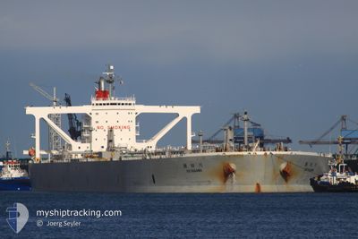
SETAGAWA
Crude Oil Tanker
Current Trip
| Time Travelled | 6 days |
|---|---|
| Remaining Time | --- |
| Distance Travelled | 440.70 nm |
| Remaining Distance | --- |
| AVG Speed | 9.4 Knopen |
| MAX Speed | 15.2 Knopen |
| AVG Wind | 7.4 knots |
| MAX Wind | 17.9 knots |
| MIN Temp | 26.9°C / 80.42°F |
| MAX Temp | 34.6°C / 94.28°F |
| Diepgang | 13.8 M |
| Positie ontvangen | 3 m geleden |
Current Position
| Lengtegraad | 56.41255° |
|---|---|
| Breedtegraat | 25.24019° |
| Status | Moored |
| Snelheid | 0.1 Knopen |
| Koers | 153° |
| Gebied | Gulf of Oman |
| Station | T-AIS |
| Positie ontvangen | 3 m geleden |
Info
Information
The current position of SETAGAWA is in Gulf of Oman with coordinates 25.24019° / 56.41255° as reported on 2024-05-14 03:45 by AIS to our vessel tracker app. The vessel's current speed is 0.1 Knopen
The vessel SETAGAWA (IMO: 9391763, MMSI: 373604000) is a Crude Oil Tanker that was built in 2009 ( 15 Jaar oud ). It's sailing under the flag of [PA] Panama.
In this page you can find informations about the vessels current position, last detected port calls, and current voyage information. If the vessels is not in coverage by AIS you will find the latest position.
The current position of SETAGAWA is detected by our AIS receivers and we are not responsible for the reliability of the data. The last position was recorded while the vessel was in Coverage by the Ais receivers of our vessel tracking app.
The current draught of SETAGAWA as reported by AIS is 13.8 meters
Weather
| Temperature | 29.8°C / 85.64°F |
|---|---|
| Wind Speed | 6 knots |
| Direction | 159° SSE |
| Pressure | 1007.6 hPa |
| Humidity | 66.3 % |
| Cloud Coverage | --- |
Featured Company
Most Visited Ports (Last year)
| Port | Arrivals | |
|---|---|---|
| 1 | ||
| 1 |
Last Trips
| Origin | Departure | Destination | Arrival | Distance |
|---|
Events
| Tijd | Evenement | Details | Positie / Bestemming | Info |
|---|---|---|---|---|
| 2024-05-14 03:45 | Status Changed | Moored Default |
25.24019 / 56.41255
SA RTA
|
Snelheid: Koers: 156° |
| 2024-05-14 03:42 | Status Changed | Default Moored |
25.24022 / 56.41257
SA RTA
|
Snelheid: Koers: 157° |
| 2024-05-14 03:39 | Status Changed | Moored Default |
25.24024 / 56.41259
SA RTA
|
Snelheid: Koers: 156° |
| 2024-05-14 03:27 | Status Changed | Default Moored |
25.24014 / 56.41260
SA RTA
|
Snelheid: 0.1 kn Koers: 157° |
| 2024-05-14 01:42 | Status Changed | Moored Default |
25.24043 / 56.41331
SA RTA
|
Snelheid: Koers: 169° |
| 2024-05-14 01:39 | Status Changed | Default Moored |
25.24045 / 56.41330
SA RTA
|
Snelheid: Koers: 168° |
| 2024-05-14 01:09 | Status Changed | Moored Default |
25.24044 / 56.41333
SA RTA
|
Snelheid: Koers: 167° |
| 2024-05-14 01:06 | Status Changed | Default Moored |
25.24043 / 56.41331
SA RTA
|
Snelheid: Koers: 166° |
| 2024-05-14 01:06 | ETA Changed | 2024/05/15 20:00 2024/05/09 08:00 |
25.24043 / 56.41326
SA RTA
|
Snelheid: Koers: 166° |
| 2024-05-14 00:48 | Draught Changed | 13.8 10.8 |
25.24042 / 56.41320
SA RTA
|
Snelheid: Koers: 165° |