

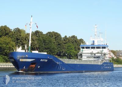
RUYTER
General Cargo

Current Trip
| Time Travelled | 3 days |
|---|---|
| Remaining Time | 2 days |
| Distance Travelled | 761.85 nm |
| Remaining Distance | 335.16 nm |
| AVG Speed | 8.1 Knopen |
| MAX Speed | 10.8 Knopen |
| AVG Wind | 12.7 knots |
| MAX Wind | 23 knots |
| MIN Temp | 2°C / 35.6°F |
| MAX Temp | 8.4°C / 47.12°F |
| Diepgang | 5.4 M |
| Positie ontvangen | 1 m geleden |
Current Position
| Lengtegraad | --- |
|---|---|
| Breedtegraat | --- |
| Status | Under way using engine |
| Snelheid | 6.8 Knopen |
| Koers | 250.8° |
| Gebied | Baltic Sea |
| Station | T-AIS |
| Positie ontvangen | 1 m geleden |
Information
The current position of RUYTER is in Baltic Sea with coordinates 54.18124° / 9.47775° as reported on 2025-03-30 04:32 by AIS to our vessel tracker app. The vessel's current speed is 6.8 Knopen and is heading at the port of VLISSINGEN. The estimated time of arrival as calculated by MyShipTracking vessel tracking app is 2025-04-01 09:12 LT
The vessel RUYTER (IMO: 9374674, MMSI: 244130641) is a General Cargo that was built in 2006 ( 19 Jaar oud ). It's sailing under the flag of [NL] Netherlands.
In this page you can find informations about the vessels current position, last detected port calls, and current voyage information. If the vessels is not in coverage by AIS you will find the latest position.
The current position of RUYTER is detected by our AIS receivers and we are not responsible for the reliability of the data. The last position was recorded while the vessel was in Coverage by the Ais receivers of our vessel tracking app.
The current draught of RUYTER as reported by AIS is 5.4 meters
Weather
| Temperature | 5.4°C / 41.72°F |
|---|---|
| Wind Speed | 17 knots |
| Direction | 225° SW |
| Pressure | 1006.9 hPa |
| Humidity | 87.6 % |
| Cloud Coverage | 100 % |


Featured Company
Last Port Calls
| Port | Arrival | Departure | Time In Port |
|---|---|---|---|
| 2025-03-26 10:54 | 2025-03-26 20:18 | 9 h | |
| 2025-03-24 06:36 | 2025-03-25 06:34 | 23 h | |
| 2025-03-16 18:23 | 2025-03-18 20:23 | 2 d | |
| 2025-03-03 08:54 | 2025-03-05 20:58 | 2 d | |
| 2025-02-20 22:05 | 2025-02-22 20:33 | 1 d | |
| 2025-02-15 14:17 | 2025-02-19 12:37 | 3 d | |
| 2025-02-06 10:17 | 2025-02-08 13:31 | 2 d | |
| 2025-02-03 01:26 | 2025-02-03 13:04 | 11 h | |
| 2025-01-28 06:23 | 2025-01-30 17:57 | 2 d | |
| 2025-01-17 17:50 | 2025-01-21 16:02 | 3 d |
Last Trips
| Origin | Departure | Destination | Arrival | Distance | |
|---|---|---|---|---|---|
| 2025-03-25 06:34 | 2025-03-26 10:54 | 190.58 nm | |||
| 2025-03-18 20:23 | 2025-03-24 06:36 | 1432.35 nm | |||
| 2025-03-05 20:58 | 2025-03-16 18:23 | 1935.41 nm | |||
| 2025-02-22 20:33 | 2025-03-03 08:54 | 1063.86 nm | |||
| 2025-02-19 12:37 | 2025-02-20 22:05 | 370.41 nm | |||
| 2025-02-08 13:31 | 2025-02-15 14:17 | 1459.20 nm | |||
| 2025-02-03 13:04 | 2025-02-06 10:17 | 425.39 nm | |||
| 2025-01-30 17:57 | 2025-02-03 01:26 | 780.89 nm | |||
| 2025-01-21 16:02 | 2025-01-28 06:23 | 1280.31 nm | |||
| 2025-01-10 07:11 | 2025-01-17 17:50 | 1099.65 nm |
Events
| Tijd | Evenement | Details | Positie / Bestemming | Info |
|---|---|---|---|---|
| 2025-03-30 01:30 | Start beweging | 5.86 nm, East of BORGSTEDT |
54.35798 / 9.87790
VLISSINGEN
|
Snelheid: 3.1 kn Koers: 293° |
| 2025-03-30 00:58 | Stop beweging | 6.17 nm, East of BORGSTEDT |
54.35458 / 9.88833
VLISSINGEN
|
Snelheid: 0.3 kn Koers: 299° |
| 2025-03-29 23:16 | Start beweging | 1.41 nm, South West of STICKENHΟRN SPORT |
54.36574 / 10.14063
VLISSINGEN
|
Snelheid: 4.1 kn Koers: 285° |
| 2025-03-29 22:53 | Stop beweging | 1.36 nm, South West of STICKENHΟRN SPORT |
54.36517 / 10.14387
VLISSINGEN
|
Snelheid: 0.2 kn Koers: 283° |
| 2025-03-29 20:38 | Wijzig zee gebeid | German part of the Baltic Sea Danish part of the Baltic Sea |
54.56306 / 10.55520
Baltic Sea
VLISSINGEN
|
Snelheid: 10.4 kn Koers: 246.4° |
| 2025-03-29 19:50 | Wijzig zee gebeid | Danish part of the Baltic Sea German part of the Baltic Sea |
54.58262 / 10.79748
Baltic Sea
VLISSINGEN
|
Snelheid: 10.6 kn Koers: 264.9° |
| 2025-03-29 17:59 | Gevonden in zee | German part of the Baltic Sea |
54.56327 / 11.33048
Baltic Sea
VLISSINGEN
|
Snelheid: 10.3 kn Koers: 289° |
| 2025-03-29 11:20 | Wijzig zee gebeid | Danish part of the Baltic Sea German part of the Baltic Sea |
54.85064 / 12.95289
Baltic Sea
VLISSINGEN
|
Snelheid: 10.1 kn Koers: 248.3° |
| 2025-03-29 08:22 | Gevonden in zee | German part of the Baltic Sea |
55.01844 / 13.75659
Baltic Sea
VLISSINGEN
|
Snelheid: 9.9 kn Koers: 247.8° |
| 2025-03-29 04:16 | Gevonden in zee | Swedish part of the Baltic Sea |
55.45108 / 14.66918
Baltic Sea
VLISSINGEN
|
Snelheid: 10.7 kn Koers: 240.5° |