

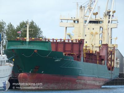
LARS D
Container Ship

Current Trip
| Time Travelled | 14 h, 18 mins |
|---|---|
| Remaining Time | 1 day |
| Distance Travelled | 173.82 nm |
| Remaining Distance | 468.88 nm |
| AVG Speed | 13.3 Knopen |
| MAX Speed | 16.3 Knopen |
| AVG Wind | 19 knots |
| MAX Wind | 21 knots |
| MIN Temp | 25.7°C / 78.26°F |
| MAX Temp | 26.4°C / 79.52°F |
| Diepgang | 7 M |
| Positie ontvangen | 4 h, 20 m geleden |
Current Position
| Lengtegraad | --- |
|---|---|
| Breedtegraat | --- |
| Status | Under way using engine |
| Snelheid | 15.9 Knopen |
| Koers | 270.1° |
| Gebied | Caribbean Sea |
| Station | T-AIS |
| Positie ontvangen | 4 h, 20 m geleden |
Information
The current position of LARS D is in Caribbean Sea with coordinates 13.06891° / -61.66080° as reported on 2025-02-17 13:24 by AIS to our vessel tracker app. The vessel's current speed is 15.9 Knopen and is heading at the port of GEORGETOWN. The estimated time of arrival as calculated by MyShipTracking vessel tracking app is 2025-02-18 19:24 LT
The vessel LARS D (IMO: 9252797, MMSI: 255806107) is a Container Ship that was built in 2003 ( 22 Jaar oud ). It's sailing under the flag of [PT] Portugal.
In this page you can find informations about the vessels current position, last detected port calls, and current voyage information. If the vessels is not in coverage by AIS you will find the latest position.
The current position of LARS D is detected by our AIS receivers and we are not responsible for the reliability of the data. The last position was recorded while the vessel was in Coverage by the Ais receivers of our vessel tracking app.
The current draught of LARS D as reported by AIS is 7 meters
Weather
| Temperature | 26.3°C / 79.34°F |
|---|---|
| Wind Speed | 17 knots |
| Direction | 85° E |
| Pressure | 1014.9 hPa |
| Humidity | 73.9 % |
| Cloud Coverage | 6 % |


Featured Company
Last Port Calls
| Port | Arrival | Departure | Time In Port |
|---|---|---|---|
| 2025-02-16 13:23 | 2025-02-17 03:27 | 14 h | |
| 2025-02-12 23:29 | 2025-02-14 09:51 | 1 d | |
| 2025-02-12 09:51 | 2025-02-12 10:27 | 36 m | |
| 2025-02-10 12:28 | 2025-02-10 20:31 | 8 h | |
| 2025-02-06 07:43 | 2025-02-07 06:07 | 22 h | |
| 2025-02-03 07:30 | 2025-02-04 04:15 | 20 h | |
| 2025-01-29 16:18 | 2025-01-30 23:23 | 1 d | |
| 2025-01-25 20:31 | 2025-01-26 07:15 | 10 h | |
| 2025-01-23 04:15 | 2025-01-24 17:47 | 1 d | |
| 2025-01-20 04:19 | 2025-01-21 00:15 | 19 h |
Most Visited Ports (Last year)
| Port | Arrivals | |
|---|---|---|
| 20 | ||
| 15 | ||
| 12 | ||
| 8 | ||
| 7 | ||
| 7 |
Last Trips
| Origin | Departure | Destination | Arrival | Distance | |
|---|---|---|---|---|---|
| 2025-02-14 05:51 | 2025-02-16 09:23 | 395.58 nm | |||
| 2025-02-12 06:27 | 2025-02-12 19:29 | 27.53 nm | |||
| 2025-02-10 16:31 | 2025-02-12 05:51 | 394.06 nm | |||
| 2025-02-07 01:07 | 2025-02-10 08:28 | 1040.40 nm | |||
| 2025-02-04 00:15 | 2025-02-06 02:43 | 449.86 nm | |||
| 2025-01-30 19:23 | 2025-02-03 03:30 | 691.78 nm | |||
| 2025-01-26 03:15 | 2025-01-29 12:18 | 222.71 nm | |||
| 2025-01-24 13:47 | 2025-01-25 16:31 | 383.41 nm | |||
| 2025-01-20 20:15 | 2025-01-23 00:15 | 409.71 nm | |||
| 2025-01-15 15:42 | 2025-01-20 00:19 | 388.84 nm |
Events
| Tijd | Evenement | Details | Positie / Bestemming | Info |
|---|---|---|---|---|
| 2025-02-17 13:30 | Status Changed | Default Under way using engine |
13.06862 / -61.68782
GYGEO
|
Snelheid: 15.9 kn Koers: 270.1° |
| 2025-02-17 13:24 | Buitenbereik |
13.06891 / -61.66080
Caribbean Sea
|
Snelheid: 15.9 kn Koers: 270.1° |
|
| 2025-02-17 11:45 | Status Changed | Under way using engine Default |
13.07614 / -61.21001
GYGEO
|
Snelheid: 11.9 kn Koers: 258° |
| 2025-02-17 11:35 | Status Changed | Default Under way using engine |
13.08350 / -61.17334
GYGEO
|
Snelheid: 11.9 kn Koers: 267° |
| 2025-02-17 10:46 | Status Changed | Under way using engine Default |
13.09314 / -61.01479
GYGEO
|
Snelheid: 11.4 kn Koers: 269° |
| 2025-02-17 10:42 | Status Changed | Default Under way using engine |
13.09314 / -61.00180
GYGEO
|
Snelheid: 11.3 kn Koers: 270.6° |
| 2025-02-17 10:36 | Status Changed | Under way using engine Default |
13.09298 / -60.98253
GYGEO
|
Snelheid: 11.2 kn Koers: 271° |
| 2025-02-17 10:34 | Status Changed | Default Under way using engine |
13.09286 / -60.97393
GYGEO
|
Snelheid: 11.2 kn Koers: 272.1° |
| 2025-02-17 10:25 | Gevonden in zee | Saint Vincent and the Grenadines part of the Caribbean Sea |
13.09273 / -60.94619
Caribbean Sea
|
Snelheid: 11.1 kn Koers: 268.1° |
| 2025-02-17 10:25 | Status Changed | Under way using engine Default |
13.09273 / -60.94461
GYGEO
|
Snelheid: 11.2 kn Koers: 269° |