

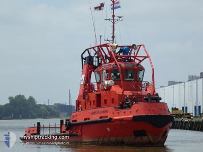
GRETTIR STERKI
Tug

Current Trip
| Time Travelled | 18 days |
|---|---|
| Remaining Time | --- |
| Distance Travelled | 2073.44 nm |
| Remaining Distance | --- |
| AVG Speed | 6.3 Knopen |
| MAX Speed | 12.4 Knopen |
| AVG Wind | 15.1 knots |
| MAX Wind | 28 knots |
| MIN Temp | -2.5°C / 27.5°F |
| MAX Temp | 14.9°C / 58.82°F |
| Diepgang | 4 M |
| Positie ontvangen | 4 m geleden |
Current Position
| Lengtegraad | --- |
|---|---|
| Breedtegraat | --- |
| Status | At anchor |
| Snelheid | |
| Koers | --- |
| Gebied | Sea of Marmara |
| Station | T-AIS |
| Positie ontvangen | 4 m geleden |
Information
The current position of GRETTIR STERKI is in Sea of Marmara with coordinates 40.67539° / 29.32610° as reported on 2025-02-22 03:09 by AIS to our vessel tracker app. The vessel's current speed is 0 Knopen
The vessel GRETTIR STERKI (IMO: 9171993, MMSI: 231888000) is a Tug It's sailing under the flag of [FO] Faroe Is.
In this page you can find informations about the vessels current position, last detected port calls, and current voyage information. If the vessels is not in coverage by AIS you will find the latest position.
The current position of GRETTIR STERKI is detected by our AIS receivers and we are not responsible for the reliability of the data. The last position was recorded while the vessel was in Coverage by the Ais receivers of our vessel tracking app.
The current draught of GRETTIR STERKI as reported by AIS is 4 meters
Weather
| Temperature | 0.2°C / 32.36°F |
|---|---|
| Wind Speed | 12 knots |
| Direction | 29° NNE |
| Pressure | 1033.6 hPa |
| Humidity | 84.8 % |
| Cloud Coverage | 94 % |


Featured Company
Most Visited Ports (Last year)
| Port | Arrivals | |
|---|---|---|
| 8 | ||
| 5 | ||
| 2 | ||
| 2 | ||
| 1 | ||
| 1 |
Events
| Tijd | Evenement | Details | Positie / Bestemming | Info |
|---|---|---|---|---|
| 2025-02-21 21:33 | Status Changed | At anchor Under way using engine |
40.67529 / 29.32618
YALOVA,TURKEY
|
Snelheid: 0.6 kn Koers: 511° |
| 2025-02-21 19:23 | Stop beweging | 2.49 nm, East of YALOVA |
40.67658 / 29.32664
YALOVA,TURKEY
|
Snelheid: 0.3 kn Koers: 511° |
| 2025-02-21 19:17 | Start beweging | 2.45 nm, East of YALOVA |
40.67657 / 29.32570
YALOVA,TURKEY
|
Snelheid: 3.2 kn Koers: 332.6° |
| 2025-02-21 19:14 | Stop beweging | 2.44 nm, East of YALOVA |
40.67399 / 29.32661
YALOVA,TURKEY
|
Snelheid: 0.1 kn Koers: 511° |
| 2025-02-21 19:06 | Status Changed | Under way using engine Restricted manoeuverability |
40.67567 / 29.32795
YALOVA,TURKEY
|
Snelheid: 5.6 kn Koers: 235.2° |
| 2025-02-21 18:19 | Start beweging | 0.71 nm, North West of YALOVA |
40.72773 / 29.46319
YALOVA,TURKEY
|
Snelheid: 7.2 kn Koers: 248.5° |
| 2025-02-21 16:53 | Stop beweging | 0.72 nm, West of YALOVA |
40.72227 / 29.45757
YALOVA,TURKEY
|
Snelheid: 0.2 kn Koers: 511° |
| 2025-02-21 16:45 | Start beweging | 0.53 nm, North West of YALOVA |
40.72265 / 29.46236
YALOVA,TURKEY
|
Snelheid: 4.3 kn Koers: 263.1° |
| 2025-02-21 16:40 | Stop beweging | 0.46 nm, North West of YALOVA |
40.72332 / 29.46478
YALOVA,TURKEY
|
Snelheid: 0.2 kn Koers: 511° |
| 2025-02-21 16:38 | Start beweging | 0.48 nm, North West of YALOVA |
40.72396 / 29.46516
YALOVA,TURKEY
|
Snelheid: 3.8 kn Koers: 201.9° |