
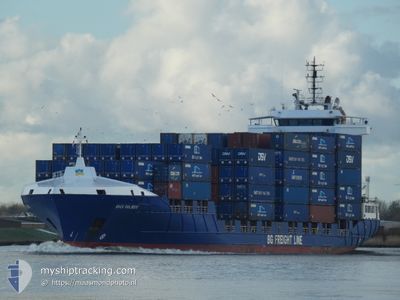
BG RUBY
Container Ship
Current Trip
| Time Travelled | 2 days |
|---|---|
| Remaining Time | 3 h, 13 mins |
| Distance Travelled | 582.93 nm |
| Remaining Distance | 60.97 nm |
| AVG Speed | 12.2 Knopen |
| MAX Speed | 17.3 Knopen |
| AVG Wind | 11.6 knots |
| MAX Wind | 32 knots |
| MIN Temp | 7°C / 44.6°F |
| MAX Temp | 11.4°C / 52.52°F |
| Diepgang | 6.4 M |
| Positie ontvangen | 1 h, 22 m geleden |
Current Position
| Lengtegraad | --- |
|---|---|
| Breedtegraat | --- |
| Status | Under way using engine |
| Snelheid | 12.9 Knopen |
| Koers | 352.6° |
| Gebied | Irish Sea and St. George's Channel |
| Station | T-AIS |
| Positie ontvangen | 1 h, 22 m geleden |
Info
Information
The current position of BG RUBY is in Irish Sea and St. George's Channel with coordinates 52.39824° / -5.93477° as reported on 2026-03-06 17:12 by AIS to our vessel tracker app. The vessel's current speed is 12.9 Knopen and is heading at the port of DUBLIN. The estimated time of arrival as calculated by MyShipTracking vessel tracking app is 2026-03-06 21:47 LT
The vessel BG RUBY (IMO: 9436202, MMSI: 255771000) is a Container Ship that was built in 2009 ( 17 Jaar oud ). It's sailing under the flag of [PT] Portugal.
In this page you can find informations about the vessels current position, last detected port calls, and current voyage information. If the vessels is not in coverage by AIS you will find the latest position.
The current position of BG RUBY is detected by our AIS receivers and we are not responsible for the reliability of the data. The last position was recorded while the vessel was in Coverage by the Ais receivers of our vessel tracking app.
The current draught of BG RUBY as reported by AIS is 6.4 meters
Weather
| Temperature | 7°C / 44.6°F |
|---|---|
| Wind Speed | 4 knots |
| Direction | 138° SE |
| Pressure | 1026.2 hPa |
| Humidity | 56.3 % |
| Cloud Coverage | --- |
Featured Company
Last Port Calls
| Port | Arrival | Departure | Time In Port |
|---|---|---|---|
| 2026-03-03 03:54 | 2026-03-04 18:22 | 1 d | |
| 2026-03-01 12:20 | 2026-03-02 03:59 | 15 h | |
| 2026-02-27 16:20 | 2026-02-28 19:19 | 1 d | |
| 2026-02-23 15:35 | 2026-02-24 16:09 | 1 d | |
| 2026-02-20 15:54 | 2026-02-21 15:40 | 23 h | |
| 2026-02-19 16:42 | 2026-02-19 23:54 | 7 h | |
| 2026-02-18 23:39 | 2026-02-19 16:35 | 16 h | |
| 2026-02-18 10:40 | 2026-02-18 23:36 | 12 h | |
| 2026-02-17 08:02 | 2026-02-18 10:36 | 1 d | |
| 2026-02-13 20:55 | 2026-02-14 22:32 | 1 d |
Most Visited Ports (Last year)
| Port | Arrivals | |
|---|---|---|
| 36 | ||
| 30 | ||
| 16 | ||
| 16 | ||
| 6 | ||
| 5 |
Last Trips
| Origin | Departure | Destination | Arrival | Distance | |
|---|---|---|---|---|---|
| 2026-03-02 03:59 | 2026-03-03 03:54 | 261.35 nm | |||
| 2026-02-28 19:19 | 2026-03-01 12:20 | 254.98 nm | |||
| 2026-02-24 16:09 | 2026-02-27 16:20 | 652.16 nm | |||
| 2026-02-21 15:40 | 2026-02-23 15:35 | 557.32 nm | |||
| 2026-02-19 23:54 | 2026-02-20 15:54 | 150.01 nm | |||
| 2026-02-19 16:35 | 2026-02-19 16:42 | 0.52 nm | |||
| 2026-02-18 23:36 | 2026-02-18 23:39 | 0.25 nm | |||
| 2026-02-18 10:36 | 2026-02-18 10:40 | 0.21 nm | |||
| 2026-02-14 22:32 | 2026-02-17 08:02 | 642.83 nm | |||
| 2026-02-09 22:15 | 2026-02-13 20:55 | 634.40 nm |
Events
| Tijd | Evenement | Details | Positie / Bestemming | Info |
|---|---|---|---|---|
| 2026-03-06 17:17 | Status Changed | Default Under way using engine |
52.41915 / -5.93941
NLRTM>IEDUB
|
Snelheid: 12.9 kn Koers: 352.6° |
| 2026-03-06 17:12 | Buitenbereik |
52.39824 / -5.93477
Irish Sea and St. George's Channel
NLRTM>IEDUB
|
Snelheid: 12.9 kn Koers: 352.6° |
|
| 2026-03-06 15:52 | Gevonden in zee | Irish part of the Irish Sea and St. George's Channel |
52.11346 / -5.83035
Irish Sea and St. George's Channel
NLRTM>IEDUB
|
Snelheid: 14.1 kn Koers: 346.4° |
| 2026-03-06 15:52 | Status Changed | Under way using engine Default |
52.11346 / -5.83035
NLRTM>IEDUB
|
Snelheid: 13 kn Koers: 349° |
| 2026-03-06 15:52 | Binnenbereik |
52.11346 / -5.83035
Irish Sea and St. George's Channel
NLRTM>IEDUB
|
Snelheid: 14.1 kn Koers: 346.4° |
|
| 2026-03-06 01:29 | Status Changed | Default Under way using engine |
50.09605 / -4.15241
NLRTM>IEDUB
|
Snelheid: 12.5 kn Koers: 254.4° |
| 2026-03-06 01:24 | Status Changed | Under way using engine Default |
50.10095 / -4.12432
NLRTM>IEDUB
|
Snelheid: 12.5 kn Koers: 255° |
| 2026-03-06 01:24 | Buitenbereik |
50.10095 / -4.12432
English Channel
NLRTM>IEDUB
|
Snelheid: 12.5 kn Koers: 254.4° |
|
| 2026-03-06 01:17 | Binnenbereik |
50.10095 / -4.12432
English Channel
NLRTM>IEDUB
|
Snelheid: 12.5 kn Koers: 254.4° |
|
| 2026-03-05 19:23 | Buitenbereik |
50.39381 / -2.10911
English Channel
NLRTM>IEDUB
|
Snelheid: 13.6 kn Koers: 258.1° |